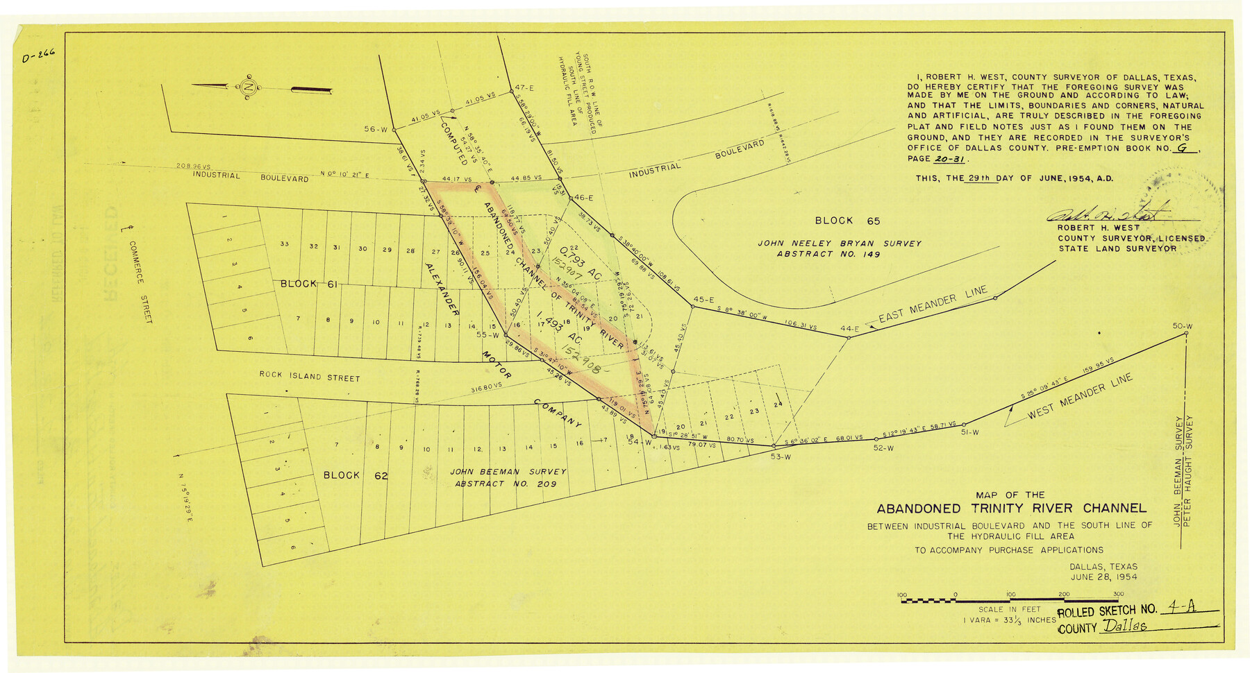
Dallas County Rolled Sketch 4A
Map of the Abandoned Trinity River Channel between Industrial Boulevard and the south line of the hydraulic fill area to accompany purchase applications
-
Map/Doc
5688
-
Collection
General Map Collection
-
Object Dates
1954/6/28 (Creation Date)
1954/7/23 (File Date)
-
People and Organizations
Robert H. West (Surveyor/Engineer)
-
Counties
Dallas
-
Subjects
Surveying Rolled Sketch
-
Height x Width
12.5 x 23.1 inches
31.8 x 58.7 cm
-
Medium
blueprint/diazo
Part of: General Map Collection
Crockett County Rolled Sketch 90

Print $20.00
- Digital $50.00
Crockett County Rolled Sketch 90
1975
Size 25.4 x 37.3 inches
Map/Doc 5631

San Jacinto County Working Sketch 11

Print $20.00
- Digital $50.00
San Jacinto County Working Sketch 11
1935
Size 40.1 x 40.0 inches
Map/Doc 63724
Culberson County Working Sketch 40

Print $40.00
- Digital $50.00
Culberson County Working Sketch 40
1966
Size 35.5 x 60.9 inches
Map/Doc 68493
McCulloch County Working Sketch 1

Print $20.00
- Digital $50.00
McCulloch County Working Sketch 1
1944
Size 29.8 x 29.9 inches
Map/Doc 70676
Liberty County Rolled Sketch O

Print $40.00
- Digital $50.00
Liberty County Rolled Sketch O
1954
Size 44.3 x 53.7 inches
Map/Doc 10183
Flight Mission No. BRA-16M, Frame 107, Jefferson County

Print $20.00
- Digital $50.00
Flight Mission No. BRA-16M, Frame 107, Jefferson County
1953
Size 18.5 x 22.3 inches
Map/Doc 85719
Flight Mission No. CGI-3N, Frame 52, Cameron County

Print $20.00
- Digital $50.00
Flight Mission No. CGI-3N, Frame 52, Cameron County
1954
Size 18.7 x 22.2 inches
Map/Doc 84558
Flight Mission No. DCL-7C, Frame 38, Kenedy County

Print $20.00
- Digital $50.00
Flight Mission No. DCL-7C, Frame 38, Kenedy County
1943
Size 15.4 x 15.1 inches
Map/Doc 86026
Flight Mission No. DAH-9M, Frame 201, Orange County

Print $20.00
- Digital $50.00
Flight Mission No. DAH-9M, Frame 201, Orange County
1953
Size 18.6 x 22.5 inches
Map/Doc 86869
Travis County Boundary File 32

Print $5.00
- Digital $50.00
Travis County Boundary File 32
Size 11.8 x 9.4 inches
Map/Doc 59473
2017 Official Travel Map, Texas

2017 Official Travel Map, Texas
2017
Size 33.5 x 36.4 inches
Map/Doc 94414
You may also like
Railroad Track Map, T&PRRCo., Culberson County, Texas

Print $4.00
- Digital $50.00
Railroad Track Map, T&PRRCo., Culberson County, Texas
1910
Size 11.8 x 18.7 inches
Map/Doc 62826
Working Sketch Cochran and Yoakum Co's.

Print $40.00
- Digital $50.00
Working Sketch Cochran and Yoakum Co's.
1919
Size 54.5 x 16.4 inches
Map/Doc 89676
Burnet County Working Sketch 15

Print $20.00
- Digital $50.00
Burnet County Working Sketch 15
1979
Size 38.2 x 30.4 inches
Map/Doc 67858
Colorado County Sketch File 9

Print $3.00
- Digital $50.00
Colorado County Sketch File 9
Size 11.3 x 17.0 inches
Map/Doc 11134
Hudspeth County Working Sketch 53-2

Print $40.00
- Digital $50.00
Hudspeth County Working Sketch 53-2
1988
Size 49.9 x 43.3 inches
Map/Doc 78210
Angelina County Working Sketch 11

Print $20.00
- Digital $50.00
Angelina County Working Sketch 11
1934
Size 40.9 x 31.8 inches
Map/Doc 67092

Irion County Rolled Sketch 4

Print $20.00
- Digital $50.00
Irion County Rolled Sketch 4
Size 25.6 x 36.4 inches
Map/Doc 6319
Galveston County Rolled Sketch JR

Print $20.00
- Digital $50.00
Galveston County Rolled Sketch JR
1938
Size 37.5 x 36.7 inches
Map/Doc 9086
Topographical Map of the Rio Grande, Sheet No. 29

Print $20.00
- Digital $50.00
Topographical Map of the Rio Grande, Sheet No. 29
1912
Map/Doc 89553
Brooks County Working Sketch 15

Print $20.00
- Digital $50.00
Brooks County Working Sketch 15
1944
Size 30.5 x 20.5 inches
Map/Doc 67799
Hansford County

Print $20.00
- Digital $50.00
Hansford County
1889
Size 22.7 x 18.9 inches
Map/Doc 4558