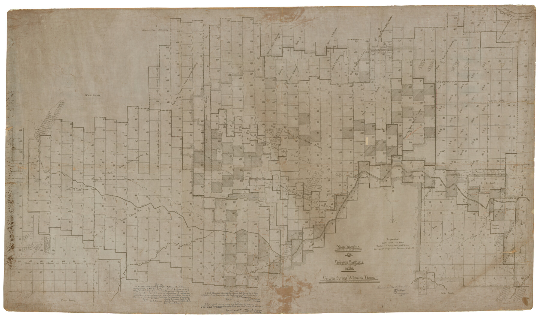
Chipman's Map of Briscoe, Hall, Motley, Cottle Counties
Map showing the Relative Positions of the various surveys delineated thereon
RO-A-8; Miscellaneous County Map 3; K-3-50
-
Map/Doc
2051
-
Collection
General Map Collection
-
Object Dates
1911 (Creation Date)
1922/9/5 (File Date)
-
People and Organizations
George H. Chipman (Surveyor/Engineer)
-
Counties
Briscoe Hall Motley Cottle
-
Height x Width
54.7 x 92.6 inches
138.9 x 235.2 cm
-
Comments
Note on reverse of map: "See S-9454 for Rasdale's Report"
Part of: General Map Collection
Delta County Sketch File 2

Print $4.00
- Digital $50.00
Delta County Sketch File 2
1871
Size 8.4 x 13.2 inches
Map/Doc 20670
Edwards County Working Sketch 74

Print $20.00
- Digital $50.00
Edwards County Working Sketch 74
1959
Size 23.6 x 38.4 inches
Map/Doc 68950
Brewster County Working Sketch 99

Print $20.00
- Digital $50.00
Brewster County Working Sketch 99
1978
Size 19.4 x 21.9 inches
Map/Doc 67699
Harris County Sketch File G

Print $4.00
- Digital $50.00
Harris County Sketch File G
1860
Size 6.6 x 7.3 inches
Map/Doc 25319
Val Verde County Working Sketch 23

Print $20.00
- Digital $50.00
Val Verde County Working Sketch 23
1932
Size 29.6 x 24.9 inches
Map/Doc 72158
Henderson County Sketch File 12

Print $8.00
- Digital $50.00
Henderson County Sketch File 12
1871
Size 8.4 x 7.4 inches
Map/Doc 26349
Navarro County Sketch File 1

Print $4.00
- Digital $50.00
Navarro County Sketch File 1
Size 9.9 x 8.0 inches
Map/Doc 32296
Denton County Working Sketch 5

Print $20.00
- Digital $50.00
Denton County Working Sketch 5
1956
Size 23.9 x 19.4 inches
Map/Doc 68610

Flight Mission No. DAG-26K, Frame 64, Matagorda County

Print $20.00
- Digital $50.00
Flight Mission No. DAG-26K, Frame 64, Matagorda County
1953
Size 18.5 x 22.2 inches
Map/Doc 86584
Flight Mission No. DAG-18K, Frame 186, Matagorda County

Print $20.00
- Digital $50.00
Flight Mission No. DAG-18K, Frame 186, Matagorda County
1952
Size 17.2 x 22.5 inches
Map/Doc 86378
Kimble County Working Sketch 65

Print $4.00
- Digital $50.00
Kimble County Working Sketch 65
1964
Size 22.1 x 17.0 inches
Map/Doc 70133
You may also like
Map of Caldwell County, Texas

Print $20.00
Map of Caldwell County, Texas
1879
Size 17.4 x 21.5 inches
Map/Doc 88914
Tierra Blanca Water Conservation Project Dam

Print $20.00
- Digital $50.00
Tierra Blanca Water Conservation Project Dam
1937
Size 37.7 x 25.1 inches
Map/Doc 92157

Maps of Gulf Intracoastal Waterway, Texas - Sabine River to the Rio Grande and connecting waterways including ship channels

Print $20.00
- Digital $50.00
Maps of Gulf Intracoastal Waterway, Texas - Sabine River to the Rio Grande and connecting waterways including ship channels
1966
Size 14.6 x 20.8 inches
Map/Doc 61993
[Cotton Belt, St. Louis Southwestern Railway of Texas, Alignment through Smith County]
![64376, [Cotton Belt, St. Louis Southwestern Railway of Texas, Alignment through Smith County], General Map Collection](https://historictexasmaps.com/wmedia_w700/maps/64376.tif.jpg)
Print $20.00
- Digital $50.00
[Cotton Belt, St. Louis Southwestern Railway of Texas, Alignment through Smith County]
1903
Size 22.0 x 29.3 inches
Map/Doc 64376
Wayland Crossing Sheet Robertson, Limestone and Leon Counties, Navasota River

Print $20.00
- Digital $50.00
Wayland Crossing Sheet Robertson, Limestone and Leon Counties, Navasota River
1934
Size 43.9 x 40.9 inches
Map/Doc 65072
Howard County Working Sketch 3

Print $20.00
- Digital $50.00
Howard County Working Sketch 3
1904
Size 26.8 x 20.1 inches
Map/Doc 66269
![92161, [Block K], Twichell Survey Records](https://historictexasmaps.com/wmedia_w700/maps/92161-1.tif.jpg)
Flight Mission No. DQN-1K, Frame 118, Calhoun County

Print $20.00
- Digital $50.00
Flight Mission No. DQN-1K, Frame 118, Calhoun County
1953
Size 18.5 x 22.2 inches
Map/Doc 84184
Outer Continental Shelf Leasing Maps (Louisiana Offshore Operations)

Print $20.00
- Digital $50.00
Outer Continental Shelf Leasing Maps (Louisiana Offshore Operations)
1959
Size 18.1 x 14.3 inches
Map/Doc 76110
Kent County Boundary File 4

Print $20.00
- Digital $50.00
Kent County Boundary File 4
Size 8.8 x 4.6 inches
Map/Doc 55828
Bailey County Sketch File 7

Print $8.00
- Digital $50.00
Bailey County Sketch File 7
1913
Size 14.0 x 8.7 inches
Map/Doc 13958