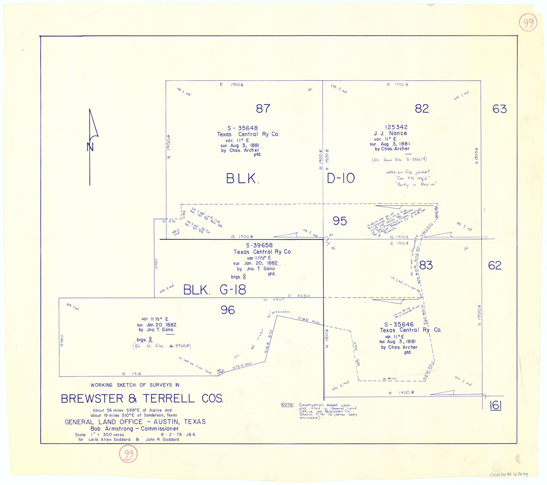
Brewster County Working Sketch 99
-
Map/Doc
67699
-
Collection
General Map Collection
-
Object Dates
8/2/1978 (Creation Date)
-
People and Organizations
Joan Kilpatrick (Draftsman)
-
Counties
Brewster
-
Subjects
Surveying Working Sketch
-
Height x Width
19.4 x 21.9 inches
49.3 x 55.6 cm
-
Scale
1" = 300 varas
Part of: General Map Collection
Flight Mission No. DQN-5K, Frame 31, Calhoun County

Print $20.00
- Digital $50.00
Flight Mission No. DQN-5K, Frame 31, Calhoun County
1953
Size 18.5 x 22.1 inches
Map/Doc 84382
Flight Mission No. BRA-9M, Frame 69, Jefferson County

Print $20.00
- Digital $50.00
Flight Mission No. BRA-9M, Frame 69, Jefferson County
1953
Size 18.5 x 22.3 inches
Map/Doc 85652
San Jacinto River, Houston Ship Channel

Print $2.00
- Digital $50.00
San Jacinto River, Houston Ship Channel
1939
Size 11.7 x 17.7 inches
Map/Doc 65150
Flight Mission No. DIX-8P, Frame 68, Aransas County

Print $20.00
- Digital $50.00
Flight Mission No. DIX-8P, Frame 68, Aransas County
1956
Size 18.7 x 22.5 inches
Map/Doc 83899
Kerr County Sketch File 13

Print $11.00
- Digital $50.00
Kerr County Sketch File 13
1927
Size 16.9 x 8.1 inches
Map/Doc 28883
Jasper County Working Sketch 23

Print $20.00
- Digital $50.00
Jasper County Working Sketch 23
1944
Size 15.9 x 22.4 inches
Map/Doc 66485
Bandera County Rolled Sketch 4

Print $20.00
- Digital $50.00
Bandera County Rolled Sketch 4
1963
Size 36.0 x 28.5 inches
Map/Doc 5116
Foard County Aerial Photograph Index Sheet 2

Print $20.00
- Digital $50.00
Foard County Aerial Photograph Index Sheet 2
1950
Size 22.1 x 18.8 inches
Map/Doc 83689
Crane County Rolled Sketch 4

Print $40.00
- Digital $50.00
Crane County Rolled Sketch 4
Size 34.7 x 51.9 inches
Map/Doc 8337
Brewster County Rolled Sketch 60

Print $40.00
- Digital $50.00
Brewster County Rolled Sketch 60
Size 36.6 x 50.3 inches
Map/Doc 10692
Jones County Working Sketch 1

Print $20.00
- Digital $50.00
Jones County Working Sketch 1
Size 21.1 x 11.2 inches
Map/Doc 66639
Yoakum County Sketch File 5

Print $10.00
- Digital $50.00
Yoakum County Sketch File 5
1899
Size 14.3 x 9.0 inches
Map/Doc 40733
You may also like
Working Sketch Bastrop County

Print $20.00
- Digital $50.00
Working Sketch Bastrop County
1923
Size 16.9 x 13.3 inches
Map/Doc 90146
Gray County Working Sketch Graphic Index

Print $20.00
- Digital $50.00
Gray County Working Sketch Graphic Index
1900
Size 43.3 x 39.4 inches
Map/Doc 76557
The Land Offices. No. 3, Liberty, December 22, 1836

Print $20.00
The Land Offices. No. 3, Liberty, December 22, 1836
2020
Size 16.0 x 21.7 inches
Map/Doc 96416

Parker County Sketch File 15

Print $4.00
- Digital $50.00
Parker County Sketch File 15
1861
Size 8.3 x 8.0 inches
Map/Doc 33548
Hudspeth County Rolled Sketch 61

Print $40.00
- Digital $50.00
Hudspeth County Rolled Sketch 61
1982
Size 71.3 x 45.1 inches
Map/Doc 9626
[Sketch for Mineral Application 16787 - Pecos River Bed, A. T. Freet]
![2815, [Sketch for Mineral Application 16787 - Pecos River Bed, A. T. Freet], General Map Collection](https://historictexasmaps.com/wmedia_w700/maps/2815-1.tif.jpg)
Print $20.00
- Digital $50.00
[Sketch for Mineral Application 16787 - Pecos River Bed, A. T. Freet]
1927
Size 20.0 x 46.7 inches
Map/Doc 2815
Fayette County Sketch File 4

Print $4.00
- Digital $50.00
Fayette County Sketch File 4
Size 11.7 x 7.9 inches
Map/Doc 22504
Flight Mission No. DAG-14K, Frame 140, Matagorda County

Print $20.00
- Digital $50.00
Flight Mission No. DAG-14K, Frame 140, Matagorda County
1952
Size 17.6 x 17.6 inches
Map/Doc 86307
Sketch Showing Original Corners Affecting Block I and Adjacent Surveys from Actual Connections by W. D. Twichell

Print $20.00
- Digital $50.00
Sketch Showing Original Corners Affecting Block I and Adjacent Surveys from Actual Connections by W. D. Twichell
Size 23.6 x 24.5 inches
Map/Doc 90156
Live Oak County Boundary File 60c

Print $4.00
- Digital $50.00
Live Oak County Boundary File 60c
Size 14.0 x 8.7 inches
Map/Doc 56421
Flight Mission No. BRA-6M, Frame 146, Jefferson County

Print $20.00
- Digital $50.00
Flight Mission No. BRA-6M, Frame 146, Jefferson County
1953
Size 18.6 x 22.3 inches
Map/Doc 85447