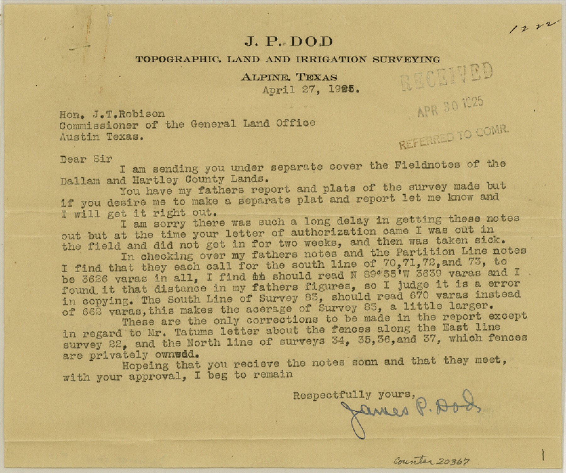
Dallam County Sketch File 10
[Correspondence in regard to Block CS]
-
Map/Doc
20367
-
Collection
General Map Collection
-
Object Dates
1925/4/27 (Creation Date)
-
People and Organizations
R.S. Dod (Surveyor/Engineer)
-
Counties
Dallam Hartley
-
Subjects
Surveying Sketch File
-
Height x Width
7.2 x 8.6 inches
18.3 x 21.8 cm
-
Medium
paper, print
Part of: General Map Collection
Map of Texas and Pacific Ry. Company's Surveys in the 80 Mile Reserve

Print $40.00
- Digital $50.00
Map of Texas and Pacific Ry. Company's Surveys in the 80 Mile Reserve
1885
Size 41.5 x 91.8 inches
Map/Doc 60313
Stephens County Sketch File 25

Print $35.00
- Digital $50.00
Stephens County Sketch File 25
1875
Size 11.0 x 15.9 inches
Map/Doc 37090
Flight Mission No. CUG-3P, Frame 192, Kleberg County

Print $20.00
- Digital $50.00
Flight Mission No. CUG-3P, Frame 192, Kleberg County
1956
Size 18.4 x 22.2 inches
Map/Doc 86296


Guadalupe County

Print $20.00
- Digital $50.00
Guadalupe County
1854
Size 25.0 x 21.1 inches
Map/Doc 3609
Morris County Rolled Sketch 1

Print $20.00
- Digital $50.00
Morris County Rolled Sketch 1
1942
Size 23.7 x 24.9 inches
Map/Doc 6835
Franklin County Sketch File 9

Print $20.00
- Digital $50.00
Franklin County Sketch File 9
Size 13.6 x 23.1 inches
Map/Doc 11515

Crockett County Sketch File 73

Print $6.00
- Digital $50.00
Crockett County Sketch File 73
1933
Size 11.2 x 8.7 inches
Map/Doc 19869
Pecos County Sketch File 36

Print $20.00
- Digital $50.00
Pecos County Sketch File 36
Size 24.9 x 35.3 inches
Map/Doc 12176
Coke County Working Sketch 17

Print $20.00
- Digital $50.00
Coke County Working Sketch 17
1948
Size 18.2 x 19.4 inches
Map/Doc 68054
You may also like
[Sketch Showing Surveys on Pease River in Hardeman County, Texas]
![10760, [Sketch Showing Surveys on Pease River in Hardeman County, Texas], Maddox Collection](https://historictexasmaps.com/wmedia_w700/maps/10760.tif.jpg)
Print $20.00
- Digital $50.00
[Sketch Showing Surveys on Pease River in Hardeman County, Texas]
Size 19.2 x 37.5 inches
Map/Doc 10760
Crockett County Working Sketch 23

Print $20.00
- Digital $50.00
Crockett County Working Sketch 23
1919
Size 35.1 x 33.7 inches
Map/Doc 68356
Nueces County Sketch File 26a

Print $14.00
- Digital $50.00
Nueces County Sketch File 26a
1894
Size 12.6 x 7.9 inches
Map/Doc 32581
Working Sketch Fisher County School Land [Leagues 105-108]
![90294, Working Sketch Fisher County School Land [Leagues 105-108], Twichell Survey Records](https://historictexasmaps.com/wmedia_w700/maps/90294-1.tif.jpg)
Print $20.00
- Digital $50.00
Working Sketch Fisher County School Land [Leagues 105-108]
Size 12.9 x 16.7 inches
Map/Doc 90294
Johnson County Sketch File 10a

Print $4.00
- Digital $50.00
Johnson County Sketch File 10a
1877
Size 6.7 x 10.6 inches
Map/Doc 28445
Val Verde County Sketch File XXX5

Print $40.00
- Digital $50.00
Val Verde County Sketch File XXX5
Size 13.2 x 13.4 inches
Map/Doc 39100
Van Zandt County Sketch File A45

Print $40.00
- Digital $50.00
Van Zandt County Sketch File A45
Size 14.2 x 13.7 inches
Map/Doc 39501
Wheeler County Working Sketch 4

Print $40.00
- Digital $50.00
Wheeler County Working Sketch 4
1972
Size 58.9 x 47.1 inches
Map/Doc 72493
[Blocks T1, T2, T3, S3, A, 05, 02 and vicinity]
![92196, [Blocks T1, T2, T3, S3, A, 05, 02 and vicinity], Twichell Survey Records](https://historictexasmaps.com/wmedia_w700/maps/92196-1.tif.jpg)
Print $20.00
- Digital $50.00
[Blocks T1, T2, T3, S3, A, 05, 02 and vicinity]
Size 20.3 x 22.9 inches
Map/Doc 92196
Henderson County Working Sketch 39

Print $20.00
- Digital $50.00
Henderson County Working Sketch 39
1982
Size 24.3 x 19.0 inches
Map/Doc 66172
Travis County Appraisal District Plat Map 2_0905

Print $20.00
- Digital $50.00
Travis County Appraisal District Plat Map 2_0905
Size 21.4 x 26.4 inches
Map/Doc 94232
Louisiana and Texas Intracoastal Waterway Proposed Extension to Rio Grande Valley

Print $20.00
- Digital $50.00
Louisiana and Texas Intracoastal Waterway Proposed Extension to Rio Grande Valley
1941
Size 28.4 x 41.3 inches
Map/Doc 61890