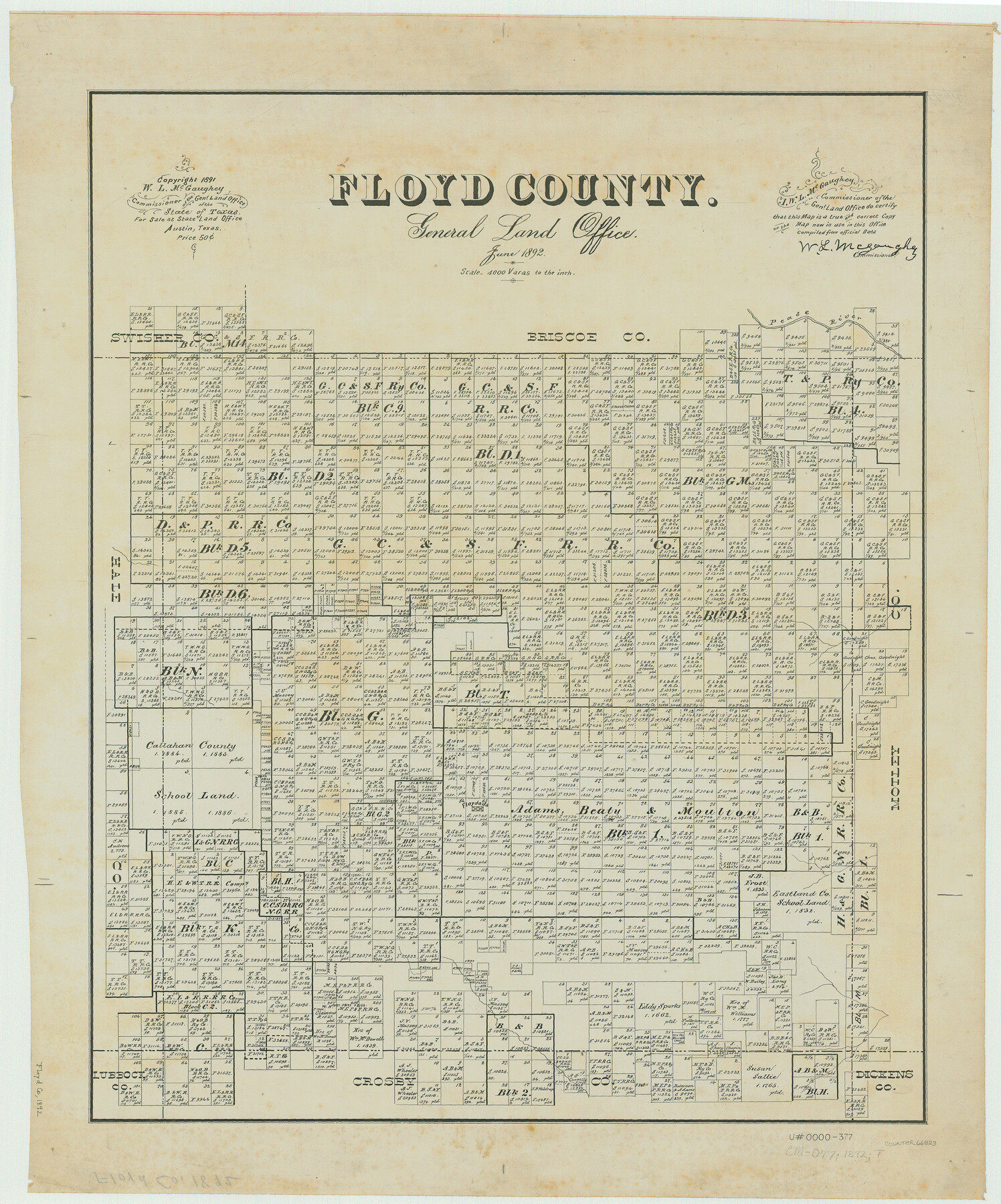
Floyd County
-
Map/Doc
66823
-
Collection
General Map Collection
-
Object Dates
1892 (Creation Date)
-
People and Organizations
Texas General Land Office (Publisher)
W.L. McGaughey (GLO Commissioner)
-
Counties
Floyd
-
Subjects
County
-
Height x Width
25.0 x 20.8 inches
63.5 x 52.8 cm
-
Comments
Copyrighted 1891.
Part of: General Map Collection
Culberson County Working Sketch 70

Print $40.00
- Digital $50.00
Culberson County Working Sketch 70
1975
Size 50.3 x 32.2 inches
Map/Doc 68524
Nueces County Working Sketch 12

Print $20.00
- Digital $50.00
Nueces County Working Sketch 12
2011
Size 22.0 x 42.3 inches
Map/Doc 90047
Howard County Rolled Sketch 8

Print $20.00
- Digital $50.00
Howard County Rolled Sketch 8
Size 16.8 x 40.2 inches
Map/Doc 6237
Flight Mission No. DAG-24K, Frame 152, Matagorda County

Print $20.00
- Digital $50.00
Flight Mission No. DAG-24K, Frame 152, Matagorda County
1953
Size 18.4 x 22.3 inches
Map/Doc 86566
Fractional Township No. 8 South Range No. 14 East of the Indian Meridian, Indian Territory

Print $20.00
- Digital $50.00
Fractional Township No. 8 South Range No. 14 East of the Indian Meridian, Indian Territory
1896
Size 19.2 x 24.3 inches
Map/Doc 75225
Flight Mission No. CRC-6R, Frame 36, Chambers County

Print $20.00
- Digital $50.00
Flight Mission No. CRC-6R, Frame 36, Chambers County
1956
Size 18.8 x 22.4 inches
Map/Doc 84969
America's Fun-Tier: Texas 1965 Official Highway Travel Map

Digital $50.00
America's Fun-Tier: Texas 1965 Official Highway Travel Map
Size 28.2 x 36.4 inches
Map/Doc 94325
Reeves County Working Sketch 65

Print $20.00
- Digital $50.00
Reeves County Working Sketch 65
1990
Size 17.3 x 19.7 inches
Map/Doc 63508
La Salle County Sketch File 35

Print $40.00
- Digital $50.00
La Salle County Sketch File 35
Size 12.1 x 19.7 inches
Map/Doc 29587
Bosque County Working Sketch 24

Print $20.00
- Digital $50.00
Bosque County Working Sketch 24
1994
Size 34.6 x 47.3 inches
Map/Doc 67458

Flight Mission No. BRA-16M, Frame 111, Jefferson County

Print $20.00
- Digital $50.00
Flight Mission No. BRA-16M, Frame 111, Jefferson County
1953
Size 18.5 x 22.2 inches
Map/Doc 85721
You may also like
From Citizens of Victoria County to Redefine the Boundary Between Jackson and Victoria Counties, November 25, 1841

Print $20.00
From Citizens of Victoria County to Redefine the Boundary Between Jackson and Victoria Counties, November 25, 1841
2020
Size 23.3 x 21.7 inches
Map/Doc 96394
[Map of Texas and Pacific Blocks from Brazos River westward through Palo Pinto, Stephens, Shackelford, Jones, Callahan, Taylor, Fisher, Nolan and Mitchell Counties]
![93456, [Map of Texas and Pacific Blocks from Brazos River westward through Palo Pinto, Stephens, Shackelford, Jones, Callahan, Taylor, Fisher, Nolan and Mitchell Counties], General Map Collection](https://historictexasmaps.com/wmedia_w700/maps/93456-1.tif.jpg)
Print $20.00
- Digital $50.00
[Map of Texas and Pacific Blocks from Brazos River westward through Palo Pinto, Stephens, Shackelford, Jones, Callahan, Taylor, Fisher, Nolan and Mitchell Counties]
Size 22.0 x 18.5 inches
Map/Doc 93456
Cooke County Rolled Sketch 7

Print $20.00
- Digital $50.00
Cooke County Rolled Sketch 7
2002
Size 44.8 x 34.9 inches
Map/Doc 77525
Comal County Sketch File 20

Print $6.00
- Digital $50.00
Comal County Sketch File 20
1857
Size 12.4 x 8.1 inches
Map/Doc 19039
[Sketch Showing South part of Capitol Lands]
![93086, [Sketch Showing South part of Capitol Lands], Twichell Survey Records](https://historictexasmaps.com/wmedia_w700/maps/93086-1.tif.jpg)
Print $20.00
- Digital $50.00
[Sketch Showing South part of Capitol Lands]
Size 47.3 x 17.7 inches
Map/Doc 93086
Concho County Rolled Sketch 12

Print $40.00
- Digital $50.00
Concho County Rolled Sketch 12
1958
Size 36.4 x 50.6 inches
Map/Doc 8657
[G. & M. Block O, M. B. & A. Block N, PSL Blocks B-19 and B-29 showing alleged vacancy]
![89812, [G. & M. Block O, M. B. & A. Block N, PSL Blocks B-19 and B-29 showing alleged vacancy], Twichell Survey Records](https://historictexasmaps.com/wmedia_w700/maps/89812-1.tif.jpg)
Print $40.00
- Digital $50.00
[G. & M. Block O, M. B. & A. Block N, PSL Blocks B-19 and B-29 showing alleged vacancy]
Size 72.2 x 36.9 inches
Map/Doc 89812
Kaufman County Working Sketch 6

Print $20.00
- Digital $50.00
Kaufman County Working Sketch 6
1937
Size 22.4 x 27.9 inches
Map/Doc 66669
Brewster County Rolled Sketch 92

Print $20.00
- Digital $50.00
Brewster County Rolled Sketch 92
1950
Size 24.3 x 15.2 inches
Map/Doc 5250
Sterling County Rolled Sketch 28

Print $20.00
- Digital $50.00
Sterling County Rolled Sketch 28
Size 28.8 x 33.4 inches
Map/Doc 7853
Map of Colorado City on the west bank of the Colorado River at the La Bahia crossing

Print $20.00
Map of Colorado City on the west bank of the Colorado River at the La Bahia crossing
1841
Size 24.4 x 32.5 inches
Map/Doc 94750
Neches River, Box Creek Sheet Cross Section

Print $6.00
- Digital $50.00
Neches River, Box Creek Sheet Cross Section
1940
Size 37.0 x 18.8 inches
Map/Doc 65079