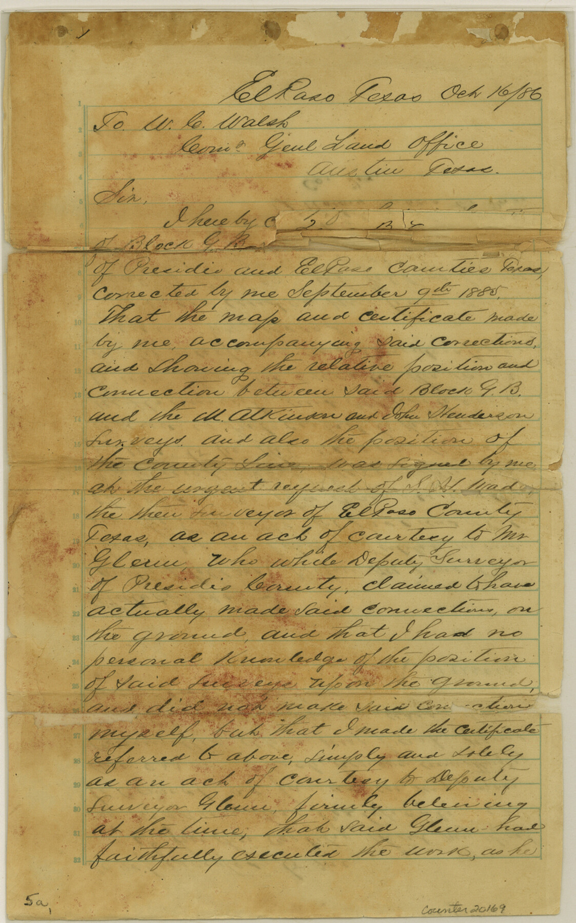
Culberson County Sketch File 5a
[Sketch in the vicinity of Van Horn's Well in Block GB]
-
Map/Doc
20169
-
Collection
General Map Collection
-
Object Dates
1885/9/18 (File Date)
1885/9/9 (Survey Date)
-
People and Organizations
T.R. Owen (Surveyor/Engineer)
Mr. Glenn (Surveyor/Engineer)
Paul McComb (Surveyor/Engineer)
-
Counties
Culberson El Paso Presidio
-
Subjects
Surveying Sketch File
-
Height x Width
14.2 x 8.8 inches
36.1 x 22.4 cm
-
Medium
paper, manuscript
-
Scale
1:4000
-
Features
Eagle Spring
Haskell
Van Horn's Well
Chispa
Rio Grande River
Part of: General Map Collection
Frio County Rolled Sketch 3

Print $20.00
- Digital $50.00
Frio County Rolled Sketch 3
Size 30.7 x 20.1 inches
Map/Doc 5916
Red River County Red River District

Print $20.00
- Digital $50.00
Red River County Red River District
1879
Size 24.9 x 21.8 inches
Map/Doc 3976
Location of the Southern Kansas Railway of Texas through Hemphill County, Texas

Print $40.00
- Digital $50.00
Location of the Southern Kansas Railway of Texas through Hemphill County, Texas
1887
Size 20.2 x 91.8 inches
Map/Doc 64000
[University Land in Loving, Ward, Winkler, Pecos, Crane, Ector, Upton, Crockett, Schleicher, Irion and Reagan Counties]
![2424, [University Land in Loving, Ward, Winkler, Pecos, Crane, Ector, Upton, Crockett, Schleicher, Irion and Reagan Counties], General Map Collection](https://historictexasmaps.com/wmedia_w700/maps/2424.tif.jpg)
Print $40.00
- Digital $50.00
[University Land in Loving, Ward, Winkler, Pecos, Crane, Ector, Upton, Crockett, Schleicher, Irion and Reagan Counties]
1938
Size 37.9 x 78.5 inches
Map/Doc 2424
El Paso County Sketch File 9

Print $44.00
- Digital $50.00
El Paso County Sketch File 9
Size 8.6 x 12.5 inches
Map/Doc 21970
Lubbock County Rolled Sketch 7

Print $20.00
- Digital $50.00
Lubbock County Rolled Sketch 7
1944
Size 25.8 x 32.9 inches
Map/Doc 6643
Coke County Working Sketch 22

Print $20.00
- Digital $50.00
Coke County Working Sketch 22
1949
Size 21.7 x 27.7 inches
Map/Doc 68059
Liberty County Sketch File 36a

Print $4.00
- Digital $50.00
Liberty County Sketch File 36a
Size 8.6 x 5.6 inches
Map/Doc 29974
Aransas County Rolled Sketch 4

Print $20.00
- Digital $50.00
Aransas County Rolled Sketch 4
1952
Size 28.9 x 26.4 inches
Map/Doc 77189
Flight Mission No. DAG-17K, Frame 60, Matagorda County

Print $20.00
- Digital $50.00
Flight Mission No. DAG-17K, Frame 60, Matagorda County
1952
Size 18.5 x 22.3 inches
Map/Doc 86322
Flight Mission No. CUG-3P, Frame 37, Kleberg County

Print $20.00
- Digital $50.00
Flight Mission No. CUG-3P, Frame 37, Kleberg County
1956
Size 18.5 x 22.2 inches
Map/Doc 86242
Flight Mission No. DQO-2K, Frame 133, Galveston County

Print $20.00
- Digital $50.00
Flight Mission No. DQO-2K, Frame 133, Galveston County
1952
Size 18.7 x 22.5 inches
Map/Doc 85030
You may also like
Hood County Working Sketch 13

Print $20.00
- Digital $50.00
Hood County Working Sketch 13
1978
Size 27.6 x 24.5 inches
Map/Doc 66207
Falls County Working Sketch 5

Print $40.00
- Digital $50.00
Falls County Working Sketch 5
2008
Size 34.3 x 56.6 inches
Map/Doc 88885
Crosby County Boundary File 4a

Print $30.00
- Digital $50.00
Crosby County Boundary File 4a
Size 8.8 x 32.8 inches
Map/Doc 52028
Grayson County Sketch File 22

Print $4.00
- Digital $50.00
Grayson County Sketch File 22
1871
Size 10.4 x 8.4 inches
Map/Doc 24501
Pecos County Rolled Sketch 165

Print $20.00
- Digital $50.00
Pecos County Rolled Sketch 165
1966
Size 23.4 x 19.6 inches
Map/Doc 7290
Red River County Working Sketch 73

Print $20.00
- Digital $50.00
Red River County Working Sketch 73
1979
Size 17.0 x 19.2 inches
Map/Doc 72056
Railroad Track Map, H&TCRRCo., Falls County, Texas

Print $4.00
- Digital $50.00
Railroad Track Map, H&TCRRCo., Falls County, Texas
1918
Size 11.7 x 18.5 inches
Map/Doc 62843
The California Case

Print $20.00
- Digital $50.00
The California Case
Size 17.6 x 12.5 inches
Map/Doc 91696
Marion County Sketch File 1a

Print $3.00
- Digital $50.00
Marion County Sketch File 1a
1867
Size 17.4 x 7.7 inches
Map/Doc 30559
Erath County Working Sketch 8

Print $20.00
- Digital $50.00
Erath County Working Sketch 8
1936
Size 16.0 x 16.2 inches
Map/Doc 69089
Part of Laguna Madre from Mosquito Trangulation Station to Sand Triangulation Station

Print $20.00
- Digital $50.00
Part of Laguna Madre from Mosquito Trangulation Station to Sand Triangulation Station
1881
Size 16.4 x 26.9 inches
Map/Doc 73488
Hood County Sketch File 3

Print $4.00
- Digital $50.00
Hood County Sketch File 3
1877
Size 12.7 x 8.1 inches
Map/Doc 26573