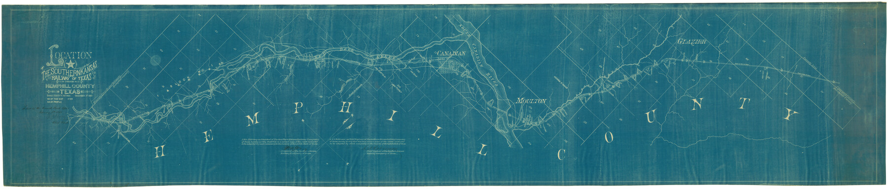
Location of the Southern Kansas Railway of Texas through Hemphill County, Texas
Southern Kansas
Z-2-1
- 
                          Map/Doc
64000
 - 
                            Collection
General Map Collection
 - 
                            Object Dates
12/1/1887 (Creation Date)
2/8/1888 (File Date)
 - 
                            People and Organizations
A.A. Robinson (Surveyor/Engineer)
R. C. Shelley (GLO Clerk)
 - 
                            Counties
Hemphill
 - 
                            Subjects
Railroads
 - 
                            Height x Width
20.2 x 91.8 inches
51.3 x 233.2 cm
 - 
                            Medium
blueprint/diazo
 - 
                            Scale
1" = 2000 feet
 - 
                            Features
SKR
Stove Pipe Creek
Mobeetie Creek
Red Deer Creek
Road to Mobeetie
Canadian
South Canadian River
Moulton
Glazier
 
Part of: General Map Collection
            The Coast & Bays of Western Texas, St. Joseph's and Mustang Islands from actual survey, the remainder from county maps, etc.


                                            Print $20.00                    
                                             -                         Digital $50.00                                    
                The Coast & Bays of Western Texas, St. Joseph's and Mustang Islands from actual survey, the remainder from county maps, etc.
1857
Size 28.0 x 18.3 inches
                                Map/Doc 72767
            
            Freestone County Working Sketch 31a


                                            Print $20.00                    
                                             -                         Digital $50.00                                    
                Freestone County Working Sketch 31a
1996
Size 25.4 x 31.9 inches
                                Map/Doc 69273
            
            Archer County Sketch File 22


                                            Print $12.00                    
                                             -                         Digital $50.00                                    
                Archer County Sketch File 22
1936
Size 11.1 x 8.6 inches
                                Map/Doc 13658
            
            Mills County Sketch File 14


                                            Print $4.00                    
                                             -                         Digital $50.00                                    
                Mills County Sketch File 14
1871
Size 6.8 x 8.0 inches
                                Map/Doc 31661
            
            Somervell County Sketch File 4


                                            Print $4.00                    
                                             -                         Digital $50.00                                    
                Somervell County Sketch File 4
Size 6.4 x 8.8 inches
                                Map/Doc 36800
            
            A Map of the Internal Provinces of New Spain


                                            Print $20.00                    
                                             -                         Digital $50.00                                    
                A Map of the Internal Provinces of New Spain
1810
Size 19.8 x 21.0 inches
                                Map/Doc 95156
            
            Cass County Working Sketch 48


                                            Print $20.00                    
                                             -                         Digital $50.00                                    
                Cass County Working Sketch 48
1992
Size 21.3 x 36.4 inches
                                Map/Doc 67951
            
            [Surveys between the Little River and Darr's Creek]


                                            Print $2.00                    
                                             -                         Digital $50.00                                    
                [Surveys between the Little River and Darr's Creek]
1846
Size 7.6 x 7.9 inches
                                Map/Doc 69757
            
            Red River County Working Sketch 34


                                            Print $6.00                    
                                             -                         Digital $50.00                                    
                Red River County Working Sketch 34
1963
Size 25.8 x 33.1 inches
                                Map/Doc 72017
            
            Cottle County Sketch File 1


                                            Print $20.00                    
                                             -                         Digital $50.00                                    
                Cottle County Sketch File 1
1882
Size 20.7 x 18.9 inches
                                Map/Doc 11189
            
            Potter County


                                            Print $20.00                    
                                             -                         Digital $50.00                                    
                Potter County
1960
Size 40.0 x 32.3 inches
                                Map/Doc 77397
            You may also like
            Castro County Rolled Sketch 14


                                            Print $20.00                    
                                             -                         Digital $50.00                                    
                Castro County Rolled Sketch 14
1965
Size 47.6 x 43.5 inches
                                Map/Doc 8608
            
            A sketch of surveys made on the coast east of Bolivar Point


                                            Print $20.00                    
                                             -                         Digital $50.00                                    
                A sketch of surveys made on the coast east of Bolivar Point
1841
Size 9.1 x 22.0 inches
                                Map/Doc 22
            
            Wichita County Sketch File 16


                                            Print $4.00                    
                                             -                         Digital $50.00                                    
                Wichita County Sketch File 16
1890
Size 12.9 x 8.9 inches
                                Map/Doc 40095
            
            Brewster County Rolled Sketch 60


                                            Print $40.00                    
                                             -                         Digital $50.00                                    
                Brewster County Rolled Sketch 60
1942
Size 42.9 x 48.0 inches
                                Map/Doc 16960
            
            Chart of the Harbour of San [Luis]


                                            Print $20.00                    
                                             -                         Digital $50.00                                    
                Chart of the Harbour of San [Luis]
1846
Size 27.3 x 18.3 inches
                                Map/Doc 72761
            
            Flight Mission No. CRE-1R, Frame 64, Jackson County


                                            Print $20.00                    
                                             -                         Digital $50.00                                    
                Flight Mission No. CRE-1R, Frame 64, Jackson County
1956
Size 15.9 x 15.9 inches
                                Map/Doc 85327
            
            Palo Pinto County Working Sketch Graphic Index


                                            Print $20.00                    
                                             -                         Digital $50.00                                    
                Palo Pinto County Working Sketch Graphic Index
1941
Map/Doc 76659
            
            Nacogdoches County Sketch File 3


                                            Print $8.00                    
                                             -                         Digital $50.00                                    
                Nacogdoches County Sketch File 3
Size 6.5 x 8.2 inches
                                Map/Doc 32237
            
            Lampasas County Boundary File 9


                                            Print $6.00                    
                                             -                         Digital $50.00                                    
                Lampasas County Boundary File 9
Size 11.2 x 8.7 inches
                                Map/Doc 56181
            
            Orange County Working Sketch Graphic Index - sheet A


                                            Print $20.00                    
                                             -                         Digital $50.00                                    
                Orange County Working Sketch Graphic Index - sheet A
1921
Size 24.4 x 29.3 inches
                                Map/Doc 76658
            
            [Surveys in Austin's Colony along the Brazos River]


                                            Print $20.00                    
                                             -                         Digital $50.00                                    
                [Surveys in Austin's Colony along the Brazos River]
1833
Size 25.0 x 23.9 inches
                                Map/Doc 164
            
            Map of Kimble County


                                            Print $20.00                    
                                             -                         Digital $50.00                                    
                Map of Kimble County
1876
Size 19.2 x 29.8 inches
                                Map/Doc 3768