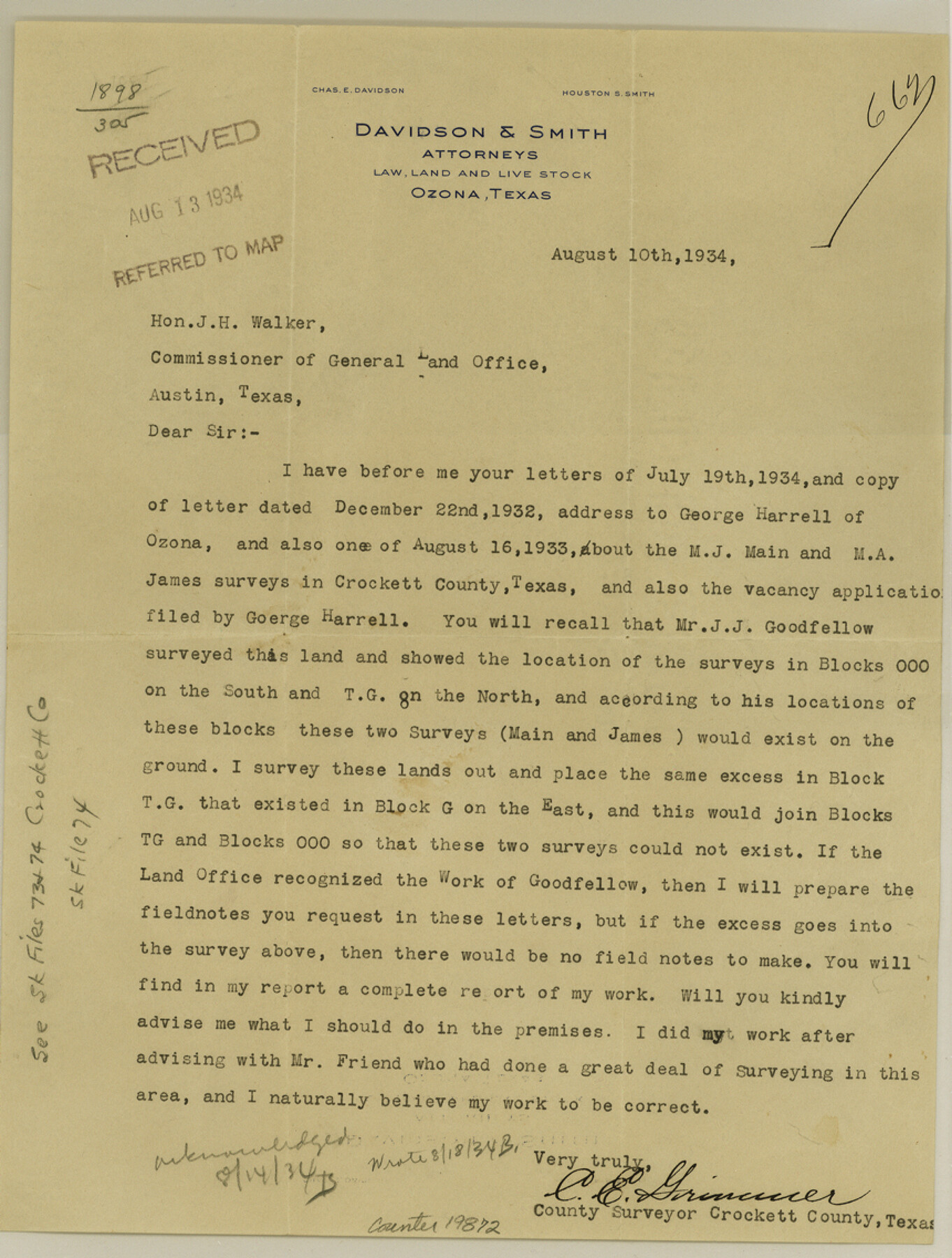
Crockett County Sketch File 74
S. E. Part of County
-
Map/Doc
19872
-
Collection
General Map Collection
-
Object Dates
1933/12/16 (Creation Date)
1934/12/24 (File Date)
1933 (Survey Date)
-
People and Organizations
Frank F. Friend (Surveyor/Engineer)
J.J. Goodfellow (Surveyor/Engineer)
C.E. Grimmer (Surveyor/Engineer)
-
Counties
Crockett
-
Subjects
Surveying Sketch File
-
Height x Width
11.4 x 8.6 inches
29.0 x 21.8 cm
-
Medium
multi-page, multi-format
-
Scale
1:1000
Part of: General Map Collection
Flight Mission No. DQN-1K, Frame 125, Calhoun County

Print $20.00
- Digital $50.00
Flight Mission No. DQN-1K, Frame 125, Calhoun County
1953
Size 18.4 x 22.1 inches
Map/Doc 84191
Kinney County Sketch File 34

Print $8.00
- Digital $50.00
Kinney County Sketch File 34
1941
Size 14.2 x 8.8 inches
Map/Doc 29181
Northeast Part of Crockett County

Print $20.00
- Digital $50.00
Northeast Part of Crockett County
1976
Size 31.4 x 41.0 inches
Map/Doc 77253
Milam County Boundary File 65a

Print $40.00
- Digital $50.00
Milam County Boundary File 65a
Size 17.2 x 30.4 inches
Map/Doc 57256
Flight Mission No. DIX-8P, Frame 86, Aransas County

Print $20.00
- Digital $50.00
Flight Mission No. DIX-8P, Frame 86, Aransas County
1956
Size 18.4 x 22.3 inches
Map/Doc 83911
Montgomery County Rolled Sketch 18

Print $40.00
- Digital $50.00
Montgomery County Rolled Sketch 18
Size 51.4 x 25.3 inches
Map/Doc 9528
Hardin County Sketch File 2

Print $7.00
- Digital $50.00
Hardin County Sketch File 2
Size 12.7 x 8.4 inches
Map/Doc 25083
El Paso County Boundary File 13

Print $37.00
- Digital $50.00
El Paso County Boundary File 13
Size 11.1 x 8.6 inches
Map/Doc 53161
Zavala County Sketch File 44

Print $25.00
- Digital $50.00
Zavala County Sketch File 44
1915
Size 10.1 x 14.3 inches
Map/Doc 41416

Eastland County Sketch File 6

Print $4.00
- Digital $50.00
Eastland County Sketch File 6
1871
Size 8.3 x 12.8 inches
Map/Doc 21572
Crockett County Working Sketch 84

Print $40.00
- Digital $50.00
Crockett County Working Sketch 84
1976
Size 49.4 x 26.2 inches
Map/Doc 68417
You may also like
Chambers County Working Sketch 15

Print $20.00
- Digital $50.00
Chambers County Working Sketch 15
1958
Size 32.9 x 27.4 inches
Map/Doc 67998
Reagan County Working Sketch 36

Print $20.00
- Digital $50.00
Reagan County Working Sketch 36
1966
Size 29.6 x 20.6 inches
Map/Doc 71878
Matagorda County Rolled Sketch 12

Print $20.00
- Digital $50.00
Matagorda County Rolled Sketch 12
Size 30.0 x 28.0 inches
Map/Doc 6681
Chambers County NRC Article 33.136 Sketch 8

Print $22.00
- Digital $50.00
Chambers County NRC Article 33.136 Sketch 8
2014
Size 17.7 x 24.0 inches
Map/Doc 94745
Orange County Sketch File 37

Print $8.00
- Digital $50.00
Orange County Sketch File 37
1950
Size 14.2 x 8.8 inches
Map/Doc 33374
[Galveston, Harrisburg & San Antonio Railroad from Cuero to Stockdale]
![64186, [Galveston, Harrisburg & San Antonio Railroad from Cuero to Stockdale], General Map Collection](https://historictexasmaps.com/wmedia_w700/maps/64186.tif.jpg)
Print $20.00
- Digital $50.00
[Galveston, Harrisburg & San Antonio Railroad from Cuero to Stockdale]
1906
Size 13.4 x 33.1 inches
Map/Doc 64186
Jackson County Working Sketch 8

Print $20.00
- Digital $50.00
Jackson County Working Sketch 8
1980
Size 30.4 x 29.0 inches
Map/Doc 66456
Galveston Entrance

Print $20.00
- Digital $50.00
Galveston Entrance
1925
Size 18.5 x 24.1 inches
Map/Doc 69859
Flight Mission No. CLL-3N, Frame 15, Willacy County

Print $20.00
- Digital $50.00
Flight Mission No. CLL-3N, Frame 15, Willacy County
1950
Size 18.4 x 22.0 inches
Map/Doc 87081
In the Supreme Court of the United States The State of Oklahoma, Complainant vs. The State of Texas, Defendant, The United States of America, Intervener - 1920

Print $20.00
- Digital $50.00
In the Supreme Court of the United States The State of Oklahoma, Complainant vs. The State of Texas, Defendant, The United States of America, Intervener - 1920
1920
Size 31.6 x 37.2 inches
Map/Doc 75115
Flight Mission No. CUG-2P, Frame 12, Kleberg County

Print $20.00
- Digital $50.00
Flight Mission No. CUG-2P, Frame 12, Kleberg County
1956
Size 18.6 x 22.1 inches
Map/Doc 86184
Chambers County Sketch File 19

Print $26.00
- Digital $50.00
Chambers County Sketch File 19
Size 14.1 x 8.6 inches
Map/Doc 17578