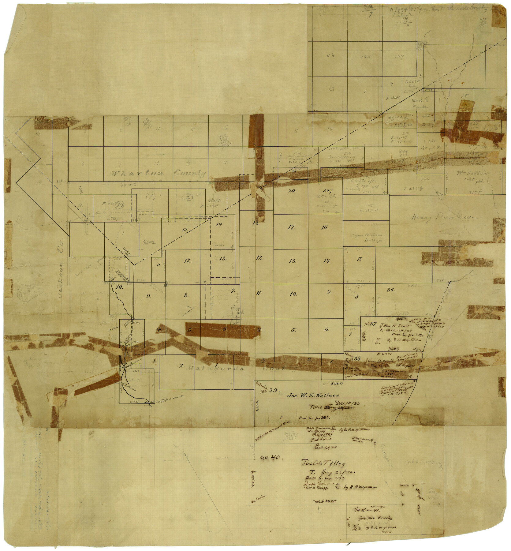
Matagorda County Rolled Sketch 12
[Sketch of surveys north and west of the Wallace and Tilley Titled surveys near the corner of Matagorda, Wharton, and Jackson Counties]
-
Map/Doc
6681
-
Collection
General Map Collection
-
Object Dates
1/6/1938 (File Date)
-
Counties
Matagorda Wharton Jackson
-
Subjects
Surveying Rolled Sketch
-
Height x Width
30.0 x 28.0 inches
76.2 x 71.1 cm
-
Medium
paper, manuscript
Part of: General Map Collection
[Galveston, Harrisburg & San Antonio through El Paso County]
![64013, [Galveston, Harrisburg & San Antonio through El Paso County], General Map Collection](https://historictexasmaps.com/wmedia_w700/maps/64013.tif.jpg)
Print $20.00
- Digital $50.00
[Galveston, Harrisburg & San Antonio through El Paso County]
1906
Size 13.5 x 33.5 inches
Map/Doc 64013
Tarrant County Working Sketch 22

Print $20.00
- Digital $50.00
Tarrant County Working Sketch 22
2001
Size 27.5 x 23.0 inches
Map/Doc 62439
Garza County Rolled Sketch 16

Print $20.00
- Digital $50.00
Garza County Rolled Sketch 16
Size 30.5 x 32.3 inches
Map/Doc 9048
Reeves County Rolled Sketch 33

Print $20.00
- Digital $50.00
Reeves County Rolled Sketch 33
Size 24.2 x 36.5 inches
Map/Doc 7502
Smith County Rolled Sketch 6A1

Print $40.00
- Digital $50.00
Smith County Rolled Sketch 6A1
Size 49.2 x 38.6 inches
Map/Doc 10704
La Salle County Working Sketch 56

Print $20.00
- Digital $50.00
La Salle County Working Sketch 56
2012
Size 25.5 x 23.0 inches
Map/Doc 93277
Flight Mission No. DQN-2K, Frame 160, Calhoun County

Print $20.00
- Digital $50.00
Flight Mission No. DQN-2K, Frame 160, Calhoun County
1953
Size 18.6 x 22.3 inches
Map/Doc 84322
King County Working Sketch 3

Print $20.00
- Digital $50.00
King County Working Sketch 3
1934
Size 10.4 x 20.1 inches
Map/Doc 70167
Flight Mission No. BQR-9K, Frame 9, Brazoria County

Print $20.00
- Digital $50.00
Flight Mission No. BQR-9K, Frame 9, Brazoria County
1952
Size 18.6 x 22.3 inches
Map/Doc 84038
Texas-New Mexico Boundary Along Rio Grande (plats)

Print $390.00
Texas-New Mexico Boundary Along Rio Grande (plats)
1933
Map/Doc 81691
Denton County Sketch File 2

Print $3.00
- Digital $50.00
Denton County Sketch File 2
1855
Size 15.4 x 9.8 inches
Map/Doc 20687
Aransas County Working Sketch 11

Print $20.00
- Digital $50.00
Aransas County Working Sketch 11
1949
Size 17.3 x 18.7 inches
Map/Doc 67178
You may also like
Hansford County

Print $20.00
- Digital $50.00
Hansford County
1889
Size 22.9 x 18.5 inches
Map/Doc 3624
Hardeman County Boundary File 3

Print $18.00
- Digital $50.00
Hardeman County Boundary File 3
Size 14.1 x 8.8 inches
Map/Doc 54375
Reagan County Rolled Sketch 31

Print $20.00
- Digital $50.00
Reagan County Rolled Sketch 31
1955
Size 26.5 x 28.8 inches
Map/Doc 7447
Cameron County NRC Article 33.136 Sketch 2

Print $20.00
- Digital $50.00
Cameron County NRC Article 33.136 Sketch 2
2002
Size 24.4 x 35.9 inches
Map/Doc 77040
Gregg County Boundary File 8

Print $8.00
- Digital $50.00
Gregg County Boundary File 8
Size 14.0 x 8.6 inches
Map/Doc 54019
Preliminary Chart of the Entrance to Matagorda Bay, Texas

Print $20.00
Preliminary Chart of the Entrance to Matagorda Bay, Texas
1857
Size 20.2 x 32.9 inches
Map/Doc 76247
Eastland County Rolled Sketch 25

Print $20.00
- Digital $50.00
Eastland County Rolled Sketch 25
1990
Size 36.9 x 47.7 inches
Map/Doc 8831
Flight Mission No. CGI-4N, Frame 192, Cameron County

Print $20.00
- Digital $50.00
Flight Mission No. CGI-4N, Frame 192, Cameron County
1955
Size 18.6 x 22.2 inches
Map/Doc 84695
Matagorda County Sketch File 11

Print $6.00
- Digital $50.00
Matagorda County Sketch File 11
1885
Size 9.7 x 6.2 inches
Map/Doc 30768
Uvalde County Working Sketch 53

Print $20.00
- Digital $50.00
Uvalde County Working Sketch 53
1982
Size 30.4 x 43.0 inches
Map/Doc 72123
Map of a part of Laguna Madre showing subdivision for mineral development

Print $20.00
- Digital $50.00
Map of a part of Laguna Madre showing subdivision for mineral development
1948
Size 42.9 x 31.0 inches
Map/Doc 2913
Plat Showing Survey for Harvest Queen Mills in Sec. 2 Blk. A & Sec. 4 Blk. O Lubbock County, Texas

Print $20.00
- Digital $50.00
Plat Showing Survey for Harvest Queen Mills in Sec. 2 Blk. A & Sec. 4 Blk. O Lubbock County, Texas
1956
Size 36.9 x 39.5 inches
Map/Doc 89893