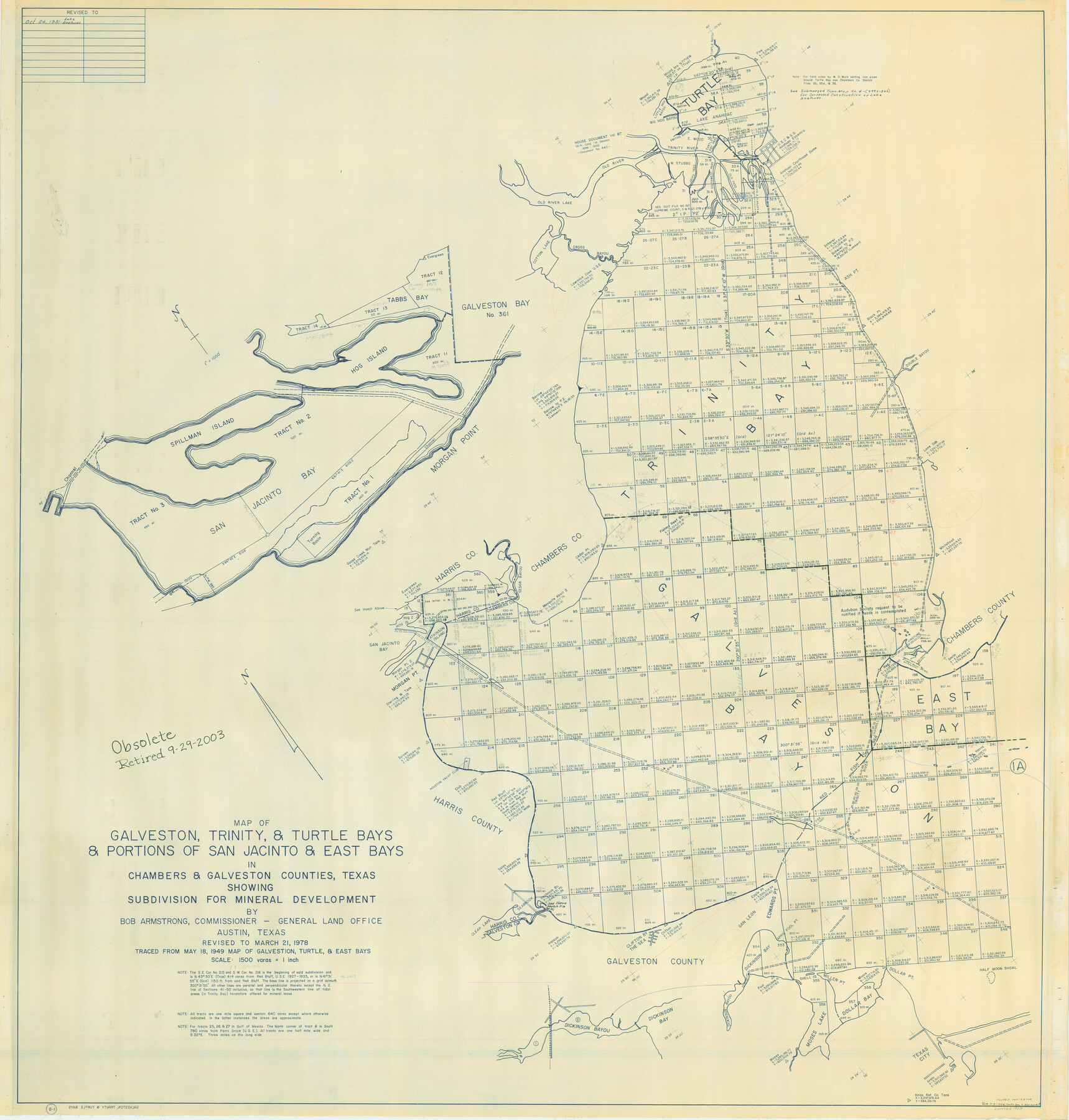
Galveston, Trinity, and Turtle Bays and Portions of San Jacinto and East Bays in Chambers and Galveston Counties, showing Subdivision for Mineral Development
-
Map/Doc
1905
-
Collection
General Map Collection
-
Object Dates
1978 (Creation Date)
-
People and Organizations
General Land Office (Publisher)
-
Counties
Chambers Galveston
-
Subjects
Energy Offshore Submerged Area
-
Height x Width
46.0 x 43.9 inches
116.8 x 111.5 cm
-
Medium
blueline cloth
-
Scale
1500 varas
-
Comments
Gulf coast and submerged state lands. Traced from map of May 18, 1949.
Part of: General Map Collection
Galveston County Working Sketch 24

Print $20.00
- Digital $50.00
Galveston County Working Sketch 24
1939
Size 16.6 x 19.6 inches
Map/Doc 69361
Coleman County Sketch File 50

Print $4.00
- Digital $50.00
Coleman County Sketch File 50
Size 12.6 x 8.2 inches
Map/Doc 18853
Kinney County Rolled Sketch 11

Print $20.00
- Digital $50.00
Kinney County Rolled Sketch 11
1944
Size 39.2 x 32.0 inches
Map/Doc 6540
Floyd County Sketch File 32a

Print $20.00
- Digital $50.00
Floyd County Sketch File 32a
1952
Size 36.5 x 33.1 inches
Map/Doc 10451
Callahan County

Print $20.00
- Digital $50.00
Callahan County
1918
Size 45.5 x 40.3 inches
Map/Doc 4787
Travis County State Real Property Sketch 7

Print $20.00
- Digital $50.00
Travis County State Real Property Sketch 7
1985
Size 30.9 x 43.4 inches
Map/Doc 61699
Trinity River, Porters Bluff Sheet

Print $20.00
- Digital $50.00
Trinity River, Porters Bluff Sheet
1925
Size 27.4 x 23.6 inches
Map/Doc 69689
Flight Mission No. DQO-2K, Frame 140, Galveston County

Print $20.00
- Digital $50.00
Flight Mission No. DQO-2K, Frame 140, Galveston County
1952
Size 18.8 x 22.5 inches
Map/Doc 85037
Newton County Boundary File 1a

Print $20.00
- Digital $50.00
Newton County Boundary File 1a
Size 36.7 x 17.8 inches
Map/Doc 57616

Cherokee County Sketch File 8

Print $4.00
- Digital $50.00
Cherokee County Sketch File 8
1854
Size 10.3 x 8.1 inches
Map/Doc 18130
Bastrop County Sketch File 14

Print $6.00
- Digital $50.00
Bastrop County Sketch File 14
2018
Size 11.0 x 8.5 inches
Map/Doc 95248
You may also like
Flight Mission No. BQR-16K, Frame 33, Brazoria County

Print $20.00
- Digital $50.00
Flight Mission No. BQR-16K, Frame 33, Brazoria County
1952
Size 18.5 x 22.3 inches
Map/Doc 84100
Matagorda County Rolled Sketch 11

Print $40.00
- Digital $50.00
Matagorda County Rolled Sketch 11
Size 39.8 x 62.0 inches
Map/Doc 8348
[Surveys along the Red River and Capitol Lands]
![90738, [Surveys along the Red River and Capitol Lands], Twichell Survey Records](https://historictexasmaps.com/wmedia_w700/maps/90738-1.tif.jpg)
Print $20.00
- Digital $50.00
[Surveys along the Red River and Capitol Lands]
Size 24.8 x 39.7 inches
Map/Doc 90738
Newton County Sketch File 15

Print $20.00
- Digital $50.00
Newton County Sketch File 15
1878
Size 29.1 x 16.8 inches
Map/Doc 42156
San Patricio County Sketch File 40

Print $4.00
- Digital $50.00
San Patricio County Sketch File 40
1842
Size 10.5 x 8.2 inches
Map/Doc 36236
Sabine River, Iron Bridge Crossing Sheet

Print $20.00
- Digital $50.00
Sabine River, Iron Bridge Crossing Sheet
1936
Size 33.0 x 40.6 inches
Map/Doc 65139
Flight Mission No. CRE-2R, Frame 165, Jackson County

Print $20.00
- Digital $50.00
Flight Mission No. CRE-2R, Frame 165, Jackson County
1956
Size 18.5 x 22.3 inches
Map/Doc 85375
Culberson County Working Sketch 36

Print $20.00
- Digital $50.00
Culberson County Working Sketch 36
1964
Size 20.8 x 24.4 inches
Map/Doc 68489
Padre Island National Seashore

Print $4.00
- Digital $50.00
Padre Island National Seashore
Size 16.0 x 21.9 inches
Map/Doc 60526
Nueces County Rolled Sketch 81

Print $278.00
- Digital $50.00
Nueces County Rolled Sketch 81
1982
Size 24.3 x 36.2 inches
Map/Doc 6960
United States - Gulf Coast - From Latitude 26° 33' to the Rio Grande Texas

Print $20.00
- Digital $50.00
United States - Gulf Coast - From Latitude 26° 33' to the Rio Grande Texas
1918
Size 18.5 x 24.5 inches
Map/Doc 72847
Hemphill County Working Sketch 14

Print $20.00
- Digital $50.00
Hemphill County Working Sketch 14
1969
Size 34.0 x 44.8 inches
Map/Doc 66109