Travis County State Real Property Sketch 7
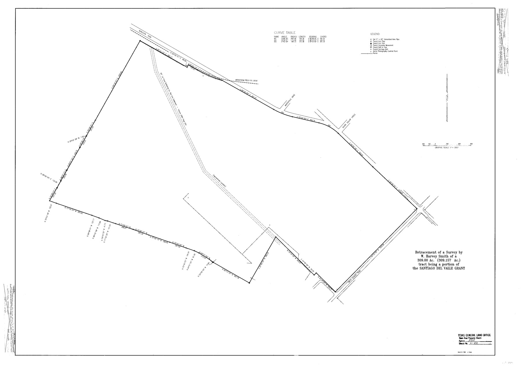
A Retracement of a Survey by W. Harvey Smith of a 309.00 acre (309.157 acre) tract being a portion of the Santiago Del Valle Grant, Smith School Road Tract, Escheat-22
S- R- P. Sketch L - 25; Travis Co. R. S. 50
-
Map/Doc
61699
-
Collection
General Map Collection
-
Object Dates
1985/3/8 (Creation Date)
-
People and Organizations
Texas General Land Office (Publisher)
Texas General Land Office (Printer)
J. Crews (Draftsman)
J. Crews (Compiler)
Garry Mauro (GLO Commissioner)
-
Counties
Travis
-
Subjects
State Real Property
-
Height x Width
30.9 x 43.4 inches
78.5 x 110.2 cm
-
Comments
Surveys located about eight miles South 10 degrees East of Austin, Texas.
One or more items in this file were formerly filed in another file. They have been reunited in this file with their original grouping. The old name on these sheets has been cro
Part of: General Map Collection
Castro County Boundary File 1 and 1a

Print $44.00
- Digital $50.00
Castro County Boundary File 1 and 1a
Size 8.9 x 9.9 inches
Map/Doc 51186
Crockett County Sketch File 24

Print $10.00
- Digital $50.00
Crockett County Sketch File 24
1881
Size 13.1 x 8.6 inches
Map/Doc 19698
Brazos County Rolled Sketch 6

Print $20.00
- Digital $50.00
Brazos County Rolled Sketch 6
1979
Size 24.3 x 36.4 inches
Map/Doc 5190
Kendall County Working Sketch 11

Print $20.00
- Digital $50.00
Kendall County Working Sketch 11
1954
Size 34.0 x 24.8 inches
Map/Doc 66683
Liberty County Sketch File 33

Print $4.00
- Digital $50.00
Liberty County Sketch File 33
Size 10.7 x 7.8 inches
Map/Doc 29967
Flight Mission No. BQR-4K, Frame 66, Brazoria County

Print $20.00
- Digital $50.00
Flight Mission No. BQR-4K, Frame 66, Brazoria County
1952
Size 18.8 x 22.5 inches
Map/Doc 83999
Flight Mission No. BQR-13K, Frame 120, Brazoria County

Print $20.00
- Digital $50.00
Flight Mission No. BQR-13K, Frame 120, Brazoria County
1952
Size 18.8 x 22.5 inches
Map/Doc 84081
Real County Working Sketch 67

Print $20.00
- Digital $50.00
Real County Working Sketch 67
1970
Size 21.2 x 16.4 inches
Map/Doc 71959
Roberts County Working Sketch 23

Print $20.00
- Digital $50.00
Roberts County Working Sketch 23
1979
Size 19.7 x 12.9 inches
Map/Doc 63549
Map of Jefferson County

Print $20.00
- Digital $50.00
Map of Jefferson County
1862
Size 22.5 x 21.9 inches
Map/Doc 3727
Map of Bosque County

Print $20.00
- Digital $50.00
Map of Bosque County
1869
Size 24.1 x 23.7 inches
Map/Doc 3313
Edwards County Working Sketch 90

Print $20.00
- Digital $50.00
Edwards County Working Sketch 90
1966
Size 33.6 x 27.2 inches
Map/Doc 68966
You may also like
Flight Mission No. DAG-26K, Frame 61, Matagorda County

Print $20.00
- Digital $50.00
Flight Mission No. DAG-26K, Frame 61, Matagorda County
1953
Size 18.7 x 22.6 inches
Map/Doc 86581
Marion County Working Sketch 36

Print $20.00
- Digital $50.00
Marion County Working Sketch 36
1987
Size 23.5 x 28.9 inches
Map/Doc 70812
Flight Mission No. BRE-2P, Frame 70, Nueces County

Print $20.00
- Digital $50.00
Flight Mission No. BRE-2P, Frame 70, Nueces County
1956
Size 18.5 x 22.6 inches
Map/Doc 86765
Ector County Working Sketch 20

Print $40.00
- Digital $50.00
Ector County Working Sketch 20
1958
Size 61.5 x 38.4 inches
Map/Doc 68863
[Surveys in Austin's Colony along the Yegua River and Cedar Creek]
![67, [Surveys in Austin's Colony along the Yegua River and Cedar Creek], General Map Collection](https://historictexasmaps.com/wmedia_w700/maps/67.tif.jpg)
Print $20.00
- Digital $50.00
[Surveys in Austin's Colony along the Yegua River and Cedar Creek]
1835
Size 15.7 x 19.3 inches
Map/Doc 67
Taylor County Sketch File 17

Print $40.00
- Digital $50.00
Taylor County Sketch File 17
Size 14.5 x 17.7 inches
Map/Doc 37811
PSL Field Notes for Block CS in Dallam County

PSL Field Notes for Block CS in Dallam County
Map/Doc 81649
Denton County Rolled Sketch 6

Print $20.00
- Digital $50.00
Denton County Rolled Sketch 6
1983
Size 25.4 x 37.2 inches
Map/Doc 5702
Cottle County Sketch File G

Print $8.00
- Digital $50.00
Cottle County Sketch File G
Size 11.5 x 7.3 inches
Map/Doc 19447
Andrews County Rolled Sketch 17

Print $40.00
- Digital $50.00
Andrews County Rolled Sketch 17
1934
Size 30.9 x 48.9 inches
Map/Doc 8393
Kerr County Sketch File 17

Print $20.00
- Digital $50.00
Kerr County Sketch File 17
1950
Size 23.3 x 23.8 inches
Map/Doc 11920
Mason County Boundary File 4

Print $38.00
- Digital $50.00
Mason County Boundary File 4
Size 8.7 x 4.0 inches
Map/Doc 56852