Kinney County Rolled Sketch 11
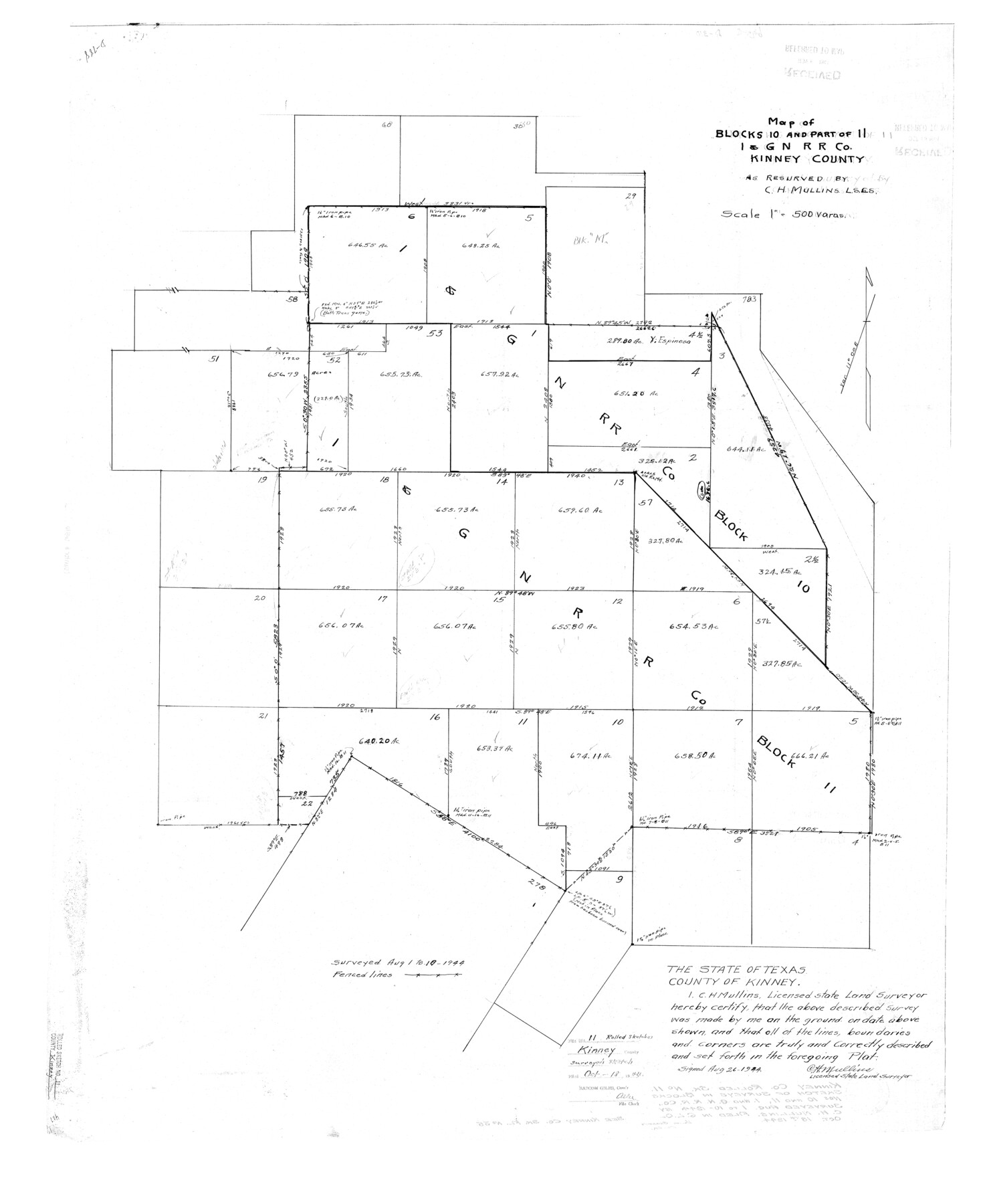
Map of Blocks 10 and part of 11, I. & G. N. R.R. Co., Kinney County
-
Map/Doc
6540
-
Collection
General Map Collection
-
Object Dates
1944/8/26 (Creation Date)
1944/8/10 (Survey Date)
1944/10/18 (File Date)
-
People and Organizations
C.H. Mullins (Surveyor/Engineer)
-
Counties
Kinney
-
Subjects
Surveying Rolled Sketch
-
Height x Width
39.2 x 32.0 inches
99.6 x 81.3 cm
-
Scale
1" = 500 varas
Related maps
Kinney County Sketch File 35

Print $6.00
- Digital $50.00
Kinney County Sketch File 35
1944
Size 14.2 x 8.7 inches
Map/Doc 29185
Part of: General Map Collection
Schleicher County Sketch File 42

Print $40.00
- Digital $50.00
Schleicher County Sketch File 42
1963
Size 16.3 x 14.4 inches
Map/Doc 36546
Flight Mission No. DQN-1K, Frame 151, Calhoun County

Print $20.00
- Digital $50.00
Flight Mission No. DQN-1K, Frame 151, Calhoun County
1953
Size 18.6 x 22.3 inches
Map/Doc 84210
Cherokee County Sketch File 4

Print $7.00
- Digital $50.00
Cherokee County Sketch File 4
1850
Size 10.3 x 8.2 inches
Map/Doc 18117
Upton County Working Sketch 58

Print $20.00
- Digital $50.00
Upton County Working Sketch 58
1988
Size 29.1 x 37.8 inches
Map/Doc 69555
Bee County Working Sketch 29a

Print $20.00
- Digital $50.00
Bee County Working Sketch 29a
1988
Size 36.3 x 43.1 inches
Map/Doc 67279
Montgomery County

Print $20.00
- Digital $50.00
Montgomery County
1861
Size 18.4 x 22.3 inches
Map/Doc 3890
Montgomery County Working Sketch 25

Print $40.00
- Digital $50.00
Montgomery County Working Sketch 25
1941
Size 50.0 x 43.7 inches
Map/Doc 71132

Grimes County Working Sketch 18

Print $20.00
- Digital $50.00
Grimes County Working Sketch 18
1990
Size 33.1 x 42.5 inches
Map/Doc 63309
Hudspeth County Rolled Sketch 41

Print $40.00
- Digital $50.00
Hudspeth County Rolled Sketch 41
1947
Size 11.3 x 96.3 inches
Map/Doc 9214
Brazoria County Boundary File 12 1/2

Print $10.00
- Digital $50.00
Brazoria County Boundary File 12 1/2
Size 9.0 x 7.3 inches
Map/Doc 50733
Hudspeth County Working Sketch 61

Print $20.00
- Digital $50.00
Hudspeth County Working Sketch 61
1992
Size 42.8 x 31.2 inches
Map/Doc 66346
You may also like
Map of Texas with population and location of principal towns and cities, according to latest reliable statistics

Print $20.00
- Digital $50.00
Map of Texas with population and location of principal towns and cities, according to latest reliable statistics
1906
Size 18.9 x 22.4 inches
Map/Doc 95869
Austin County Rolled Sketch 5A

Print $40.00
- Digital $50.00
Austin County Rolled Sketch 5A
Size 54.2 x 44.1 inches
Map/Doc 8437
Bahia de S. Bernardo

Print $20.00
- Digital $50.00
Bahia de S. Bernardo
1809
Size 17.0 x 25.2 inches
Map/Doc 95142
Falls County Sketch File 29

Print $40.00
- Digital $50.00
Falls County Sketch File 29
Size 19.9 x 23.5 inches
Map/Doc 75994
Map Showing the position of surveys 1 & 2, B.S. & F. Cert 1/356

Print $20.00
- Digital $50.00
Map Showing the position of surveys 1 & 2, B.S. & F. Cert 1/356
1915
Size 22.0 x 11.1 inches
Map/Doc 10768
Nautical Chart 152-SC - Galveston Bay, Texas

Print $20.00
- Digital $50.00
Nautical Chart 152-SC - Galveston Bay, Texas
1972
Size 14.9 x 32.8 inches
Map/Doc 69889
Bexar County Sketch File 61

Print $61.00
- Digital $50.00
Bexar County Sketch File 61
2019
Size 11.0 x 8.5 inches
Map/Doc 95709
Williamson County Boundary File 3

Print $20.00
- Digital $50.00
Williamson County Boundary File 3
Size 18.5 x 23.6 inches
Map/Doc 60012
![[San Benito Promotional Booklet]](https://historictexasmaps.com/wmedia_w700/pdf_converted_jpg/qi_pdf_thumbnail_64211.jpg)
Trinity County

Print $20.00
- Digital $50.00
Trinity County
1946
Size 42.5 x 42.8 inches
Map/Doc 73306
Medina County, Texas

Print $20.00
- Digital $50.00
Medina County, Texas
1879
Size 31.8 x 26.4 inches
Map/Doc 579
Hunt County Rolled Sketch 1

Print $20.00
- Digital $50.00
Hunt County Rolled Sketch 1
Size 28.3 x 18.4 inches
Map/Doc 6266