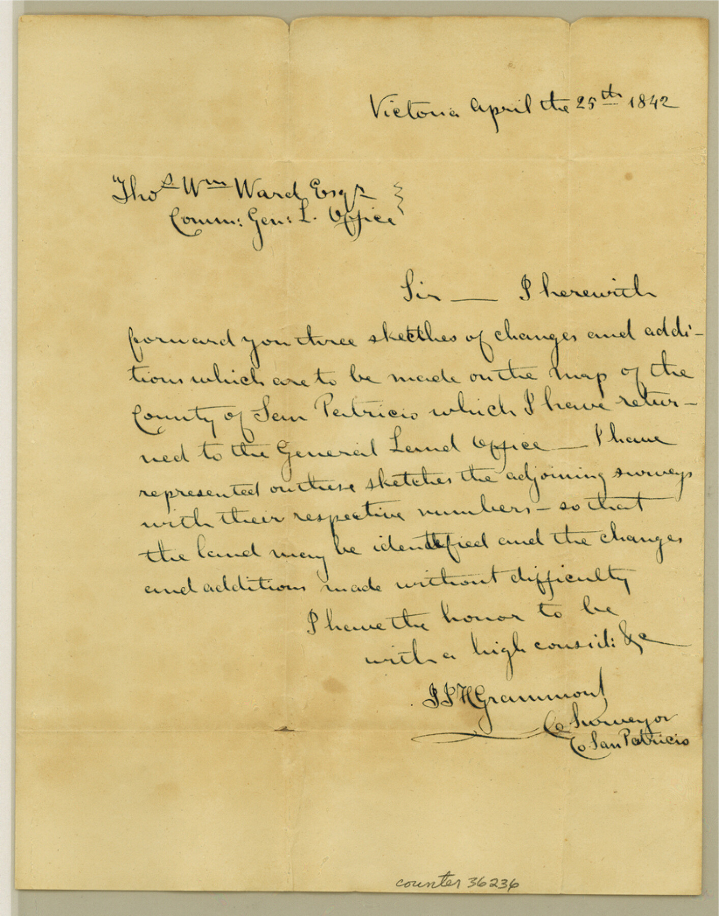
San Patricio County Sketch File 40
[Letter from County Surveyor that accompanied sketches sent to the GLO]
- 
                          Map/Doc
36236
 - 
                            Collection
General Map Collection
 - 
                            Object Dates
4/25/1842 (Creation Date)
12/11/1984 (File Date)
 - 
                            People and Organizations
J.J.H. Grammond ()
 - 
                            Counties
San Patricio
 - 
                            Subjects
Surveying Sketch File
 - 
                            Height x Width
10.5 x 8.2 inches
26.7 x 20.8 cm
 - 
                            Medium
paper, manuscript
 
Part of: General Map Collection
            Hood County Sketch File 23a


                                            Print $20.00                    
                                             -                         Digital $50.00                                    
                Hood County Sketch File 23a
1887
Size 17.2 x 16.5 inches
                                Map/Doc 11781
            
            Sutton County Sketch File 41


                                            Print $4.00                    
                                             -                         Digital $50.00                                    
                Sutton County Sketch File 41
1940
Size 14.4 x 8.6 inches
                                Map/Doc 37507
            
            Map of section no. 7 of a survey of Padre Island made for the Office of the Attorney General of the State of Texas


                                            Print $40.00                    
                                             -                         Digital $50.00                                    
                Map of section no. 7 of a survey of Padre Island made for the Office of the Attorney General of the State of Texas
1941
Size 56.3 x 41.2 inches
                                Map/Doc 2263
            
            Sterling County Rolled Sketch 14


                                            Print $20.00                    
                                             -                         Digital $50.00                                    
                Sterling County Rolled Sketch 14
Size 22.3 x 26.6 inches
                                Map/Doc 7848
            
            [Gulf Colorado & Santa Fe from 2178+36.0 to 3901+06.2]


                                            Print $40.00                    
                                             -                         Digital $50.00                                    
                [Gulf Colorado & Santa Fe from 2178+36.0 to 3901+06.2]
Size 31.9 x 58.9 inches
                                Map/Doc 64699
            
            Map of the State of Texas


                                            Print $40.00                    
                                             -                         Digital $50.00                                    
                Map of the State of Texas
1879
Size 102.3 x 106.1 inches
                                Map/Doc 16974
            
            Nueces County Rolled Sketch 57


                                            Print $48.00                    
                                    
                Nueces County Rolled Sketch 57
1979
Size 18.9 x 24.6 inches
                                Map/Doc 6897
            
            Right of Way and Track Map Texas & New Orleans R.R. Co. operated by the T. & N. O. R.R. Co. Dallas-Sabine Branch


                                            Print $40.00                    
                                             -                         Digital $50.00                                    
                Right of Way and Track Map Texas & New Orleans R.R. Co. operated by the T. & N. O. R.R. Co. Dallas-Sabine Branch
1918
Size 26.1 x 56.7 inches
                                Map/Doc 64150
            
            Goliad County Sketch File 26a


                                            Print $10.00                    
                                             -                         Digital $50.00                                    
                Goliad County Sketch File 26a
Size 12.8 x 8.3 inches
                                Map/Doc 24321
            
            Pecos County Rolled Sketch 146A


                                            Print $37.00                    
                                             -                         Digital $50.00                                    
                Pecos County Rolled Sketch 146A
1957
Size 10.4 x 15.2 inches
                                Map/Doc 48396
            
            Hansford County Sketch File 11


                                            Print $6.00                    
                                             -                         Digital $50.00                                    
                Hansford County Sketch File 11
Size 11.2 x 8.7 inches
                                Map/Doc 24972
            
            Dickens County Sketch File 15


                                            Print $4.00                    
                                             -                         Digital $50.00                                    
                Dickens County Sketch File 15
Size 12.6 x 8.0 inches
                                Map/Doc 20973
            You may also like
            Sabine Bank to East Bay including Heald Bank


                                            Print $20.00                    
                                             -                         Digital $50.00                                    
                Sabine Bank to East Bay including Heald Bank
1957
Size 45.0 x 34.4 inches
                                Map/Doc 69846
            
            Maps of Gulf Intracoastal Waterway, Texas - Sabine River to the Rio Grande and connecting waterways including ship channels


                                            Print $20.00                    
                                             -                         Digital $50.00                                    
                Maps of Gulf Intracoastal Waterway, Texas - Sabine River to the Rio Grande and connecting waterways including ship channels
1966
Size 14.6 x 22.3 inches
                                Map/Doc 61957
            
            Schleicher County Rolled Sketch 9


                                            Print $20.00                    
                                             -                         Digital $50.00                                    
                Schleicher County Rolled Sketch 9
Size 22.7 x 22.0 inches
                                Map/Doc 7751
            
            Menard County Rolled Sketch 16


                                            Print $20.00                    
                                             -                         Digital $50.00                                    
                Menard County Rolled Sketch 16
1983
Size 29.8 x 36.6 inches
                                Map/Doc 6762
            
            Cottle County Working Sketch Graphic Index


                                            Print $20.00                    
                                             -                         Digital $50.00                                    
                Cottle County Working Sketch Graphic Index
1971
Size 41.8 x 33.8 inches
                                Map/Doc 76506
            
            [Blk. O1, W. H. Godair]


                                            Print $20.00                    
                                             -                         Digital $50.00                                    
                [Blk. O1, W. H. Godair]
1913
Size 30.1 x 10.3 inches
                                Map/Doc 90632
            
            Newton County Working Sketch 40


                                            Print $20.00                    
                                             -                         Digital $50.00                                    
                Newton County Working Sketch 40
1970
Size 43.6 x 39.7 inches
                                Map/Doc 71286
            
            Sutton County Rolled Sketch 58


                                            Print $20.00                    
                                             -                         Digital $50.00                                    
                Sutton County Rolled Sketch 58
Size 31.2 x 15.9 inches
                                Map/Doc 7896
            
            Williamson County Rolled Sketch 5


                                            Print $20.00                    
                                             -                         Digital $50.00                                    
                Williamson County Rolled Sketch 5
1940
Size 23.7 x 34.5 inches
                                Map/Doc 8263
            
            Hays County Working Sketch 12


                                            Print $20.00                    
                                             -                         Digital $50.00                                    
                Hays County Working Sketch 12
1950
Size 22.8 x 24.3 inches
                                Map/Doc 66086
            
            Flight Mission No. BRA-8M, Frame 22, Jefferson County


                                            Print $20.00                    
                                             -                         Digital $50.00                                    
                Flight Mission No. BRA-8M, Frame 22, Jefferson County
1953
Size 18.5 x 22.4 inches
                                Map/Doc 85577