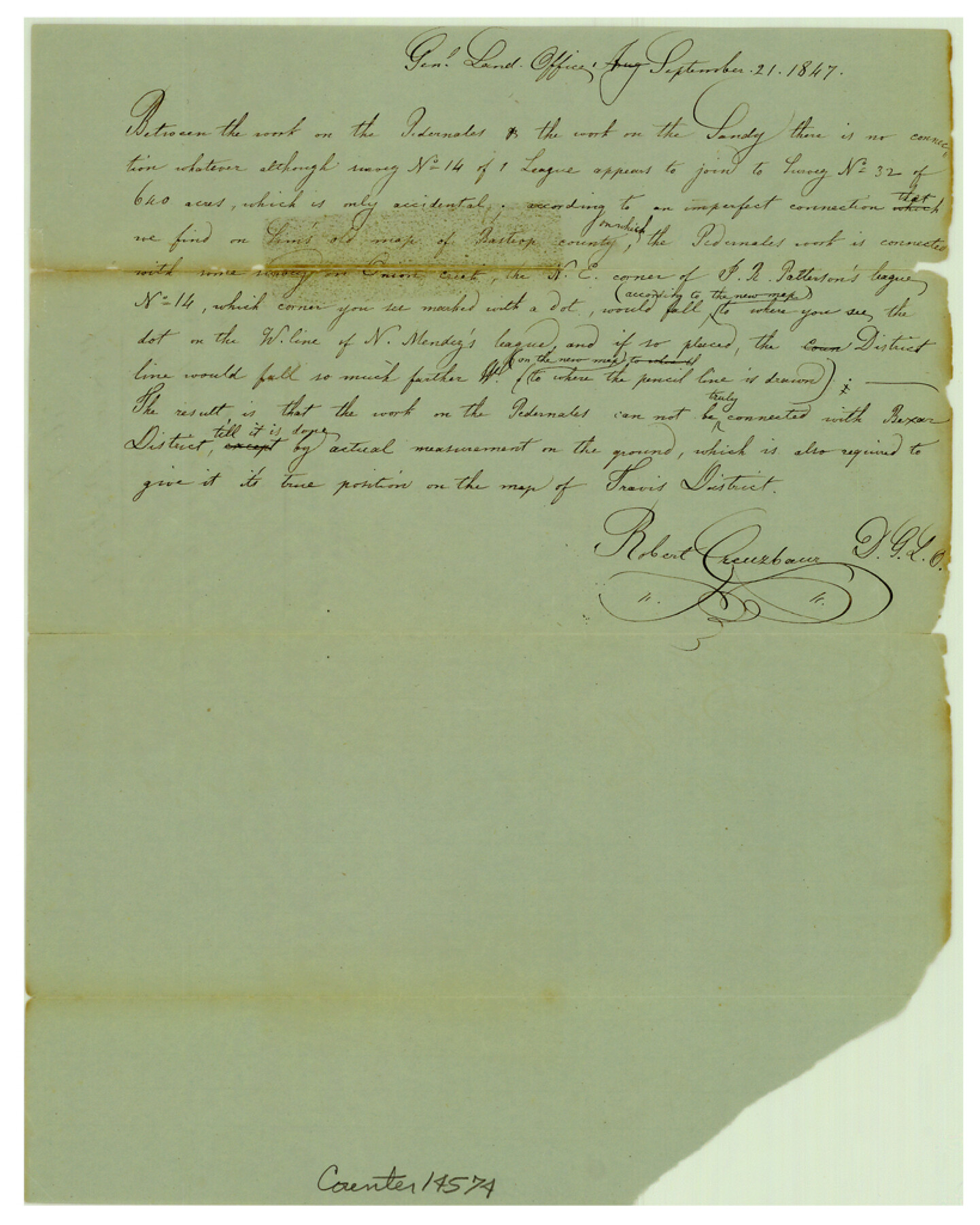
Bexar County Sketch File 58a
[Copy of letter sent by GLO draftsman to John James in reply to his letter]
-
Map/Doc
14574
-
Collection
General Map Collection
-
Object Dates
1847/9/21 (Creation Date)
1984/12/7 (File Date)
-
People and Organizations
John James (Surveyor/Engineer)
Robert Creuzbaur (Draftsman)
-
Counties
Bexar
-
Subjects
Surveying Sketch File
-
Height x Width
10.2 x 8.2 inches
25.9 x 20.8 cm
-
Medium
paper, manuscript
-
Features
Pedernales River
Sandy Creek
Onion Creek
Part of: General Map Collection
Flight Mission No. CUG-1P, Frame 81, Kleberg County

Print $20.00
- Digital $50.00
Flight Mission No. CUG-1P, Frame 81, Kleberg County
1956
Size 18.5 x 22.2 inches
Map/Doc 86146
McLennan County Working Sketch 1

Print $20.00
- Digital $50.00
McLennan County Working Sketch 1
1941
Size 21.5 x 29.6 inches
Map/Doc 70694
Fort Bend County Rolled Sketch 4

Print $20.00
- Digital $50.00
Fort Bend County Rolled Sketch 4
1956
Size 30.1 x 43.8 inches
Map/Doc 5894
Harrison County Working Sketch 30

Print $20.00
- Digital $50.00
Harrison County Working Sketch 30
2001
Size 29.5 x 31.9 inches
Map/Doc 66050
Jefferson County Rolled Sketch 26

Print $40.00
- Digital $50.00
Jefferson County Rolled Sketch 26
Size 28.4 x 56.4 inches
Map/Doc 9291
Grayson County Sketch File 24

Print $4.00
- Digital $50.00
Grayson County Sketch File 24
1872
Size 8.1 x 10.0 inches
Map/Doc 24505


Texas 1973 Official Highway Travel Map

Texas 1973 Official Highway Travel Map
Size 28.2 x 36.3 inches
Map/Doc 94405
Flight Mission No. CRE-1R, Frame 134, Jackson County

Print $20.00
- Digital $50.00
Flight Mission No. CRE-1R, Frame 134, Jackson County
1956
Size 16.2 x 16.0 inches
Map/Doc 85342
Flight Mission No. DQN-2K, Frame 25, Calhoun County

Print $20.00
- Digital $50.00
Flight Mission No. DQN-2K, Frame 25, Calhoun County
1953
Size 18.8 x 22.4 inches
Map/Doc 84232
San Jacinto County Working Sketch 9

Print $20.00
- Digital $50.00
San Jacinto County Working Sketch 9
1935
Size 36.1 x 42.1 inches
Map/Doc 63722
You may also like
Bexar County Sketch File 31

Print $40.00
- Digital $50.00
Bexar County Sketch File 31
1867
Size 11.3 x 16.4 inches
Map/Doc 10920
Erath County Rolled Sketch 2A

Print $20.00
- Digital $50.00
Erath County Rolled Sketch 2A
Size 18.8 x 21.4 inches
Map/Doc 5862
[E. L. & R.R. Block 1, G. C. & S. F. Blocks 1 & 2, T. R. R. Block 4]
![91280, [E. L. & R.R. Block 1, G. C. & S. F. Blocks 1 & 2, T. R. R. Block 4], Twichell Survey Records](https://historictexasmaps.com/wmedia_w700/maps/91280-1.tif.jpg)
Print $20.00
- Digital $50.00
[E. L. & R.R. Block 1, G. C. & S. F. Blocks 1 & 2, T. R. R. Block 4]
Size 8.7 x 19.3 inches
Map/Doc 91280
Map No. 1 - Rio Bravo del Norte section of boundary between the United States & Mexico agreed upon by the Joint Commission under the Treaty of Guadalupe Hidalgo

Print $20.00
- Digital $50.00
Map No. 1 - Rio Bravo del Norte section of boundary between the United States & Mexico agreed upon by the Joint Commission under the Treaty of Guadalupe Hidalgo
1852
Size 18.2 x 27.2 inches
Map/Doc 72865

The Chief Justice County of Mina. Lands in Conflict with Colorado County

Print $20.00
The Chief Justice County of Mina. Lands in Conflict with Colorado County
2020
Size 15.8 x 21.7 inches
Map/Doc 96062
Hutchinson County Working Sketch Graphic Index - sheet 1

Print $20.00
- Digital $50.00
Hutchinson County Working Sketch Graphic Index - sheet 1
1922
Size 44.1 x 36.8 inches
Map/Doc 76586
[Section 114, Block Z2]
![90371, [Section 114, Block Z2], Twichell Survey Records](https://historictexasmaps.com/wmedia_w700/maps/90371-1.tif.jpg)
Print $2.00
- Digital $50.00
[Section 114, Block Z2]
1907
Size 8.9 x 10.1 inches
Map/Doc 90371
Hutchinson County Sketch File 26

Print $20.00
- Digital $50.00
Hutchinson County Sketch File 26
1920
Size 18.6 x 17.4 inches
Map/Doc 11816
Webb County Working Sketch 66

Print $40.00
- Digital $50.00
Webb County Working Sketch 66
1966
Size 62.8 x 42.5 inches
Map/Doc 72433
Robertson County Working Sketch 3

Print $20.00
- Digital $50.00
Robertson County Working Sketch 3
1969
Size 36.5 x 30.8 inches
Map/Doc 63576
Titus County Sketch File 11

Print $4.00
- Digital $50.00
Titus County Sketch File 11
1872
Size 8.2 x 10.1 inches
Map/Doc 38150