Brewster County Rolled Sketch 65
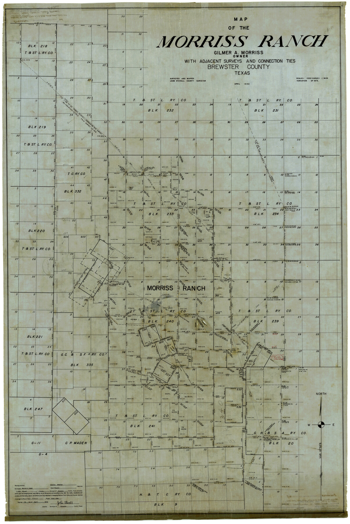
Map of the Morriss Ranch, Gilmer A. Morriss, Owner with adjacent surveys and connection ties
-
Map/Doc
8489
-
Collection
General Map Collection
-
Object Dates
4/1940 (Creation Date)
5/6/1940 (File Date)
-
People and Organizations
John Stovell (Surveyor/Engineer)
-
Counties
Brewster
-
Subjects
Surveying Rolled Sketch
-
Height x Width
57.0 x 38.8 inches
144.8 x 98.6 cm
-
Medium
linen, manuscript
-
Comments
See Brewster County Sketch File 48 (16327) for correspondence.
Related maps
Brewster County Sketch File 18

Print $8.00
- Digital $50.00
Brewster County Sketch File 18
1942
Size 13.8 x 7.6 inches
Map/Doc 15813
Brewster County Sketch File 48

Print $4.00
- Digital $50.00
Brewster County Sketch File 48
1940
Size 11.4 x 9.2 inches
Map/Doc 16327
Part of: General Map Collection
Jasper County Sketch File 21

Print $4.00
- Digital $50.00
Jasper County Sketch File 21
Size 13.4 x 8.9 inches
Map/Doc 27820
Dépt. des Ardennes

Print $20.00
- Digital $50.00
Dépt. des Ardennes
Size 14.5 x 20.5 inches
Map/Doc 94448
Matagorda County

Print $40.00
- Digital $50.00
Matagorda County
1920
Size 39.7 x 49.1 inches
Map/Doc 77368
[Sketch for Mineral Application 24072, San Jacinto River]
![65607, [Sketch for Mineral Application 24072, San Jacinto River], General Map Collection](https://historictexasmaps.com/wmedia_w700/maps/65607.tif.jpg)
Print $20.00
- Digital $50.00
[Sketch for Mineral Application 24072, San Jacinto River]
1929
Size 23.3 x 17.8 inches
Map/Doc 65607
Kinney County Sketch File 40

Print $6.00
Kinney County Sketch File 40
Size 14.0 x 8.5 inches
Map/Doc 97247
Brazos River, Brazos River Sheet 8

Print $4.00
- Digital $50.00
Brazos River, Brazos River Sheet 8
1926
Size 22.6 x 29.2 inches
Map/Doc 65301

El Paso County Rolled Sketch 43B

Print $20.00
- Digital $50.00
El Paso County Rolled Sketch 43B
Size 22.0 x 22.0 inches
Map/Doc 5830
Flight Mission No. CRC-2R, Frame 114, Chambers County

Print $20.00
- Digital $50.00
Flight Mission No. CRC-2R, Frame 114, Chambers County
1956
Size 18.5 x 22.4 inches
Map/Doc 84741
Uvalde County Working Sketch 26

Print $20.00
- Digital $50.00
Uvalde County Working Sketch 26
1954
Size 37.2 x 31.9 inches
Map/Doc 72096
Blanco County Working Sketch 40

Print $20.00
- Digital $50.00
Blanco County Working Sketch 40
1986
Size 28.3 x 24.5 inches
Map/Doc 67400
Glasscock County Sketch File 12

Print $5.00
- Digital $50.00
Glasscock County Sketch File 12
1935
Size 14.1 x 9.2 inches
Map/Doc 24176
You may also like
Flight Mission No. DQN-2K, Frame 24, Calhoun County

Print $20.00
- Digital $50.00
Flight Mission No. DQN-2K, Frame 24, Calhoun County
1953
Size 18.6 x 22.2 inches
Map/Doc 84231
Map of the Town of Wilson

Print $20.00
- Digital $50.00
Map of the Town of Wilson
1924
Size 24.6 x 26.7 inches
Map/Doc 92958
Newton County Working Sketch 43

Print $20.00
- Digital $50.00
Newton County Working Sketch 43
1982
Size 20.7 x 28.6 inches
Map/Doc 71289
Map of Chambers County, Texas

Print $20.00
- Digital $50.00
Map of Chambers County, Texas
1879
Size 26.3 x 30.7 inches
Map/Doc 695
Flight Mission No. DQO-2K, Frame 149, Galveston County

Print $20.00
- Digital $50.00
Flight Mission No. DQO-2K, Frame 149, Galveston County
1952
Size 18.8 x 22.4 inches
Map/Doc 85046
Pecos County Sketch File 94

Print $20.00
- Digital $50.00
Pecos County Sketch File 94
1956
Size 25.8 x 17.3 inches
Map/Doc 12185
Trinity River, Crabtree Ferry Sheet

Print $20.00
- Digital $50.00
Trinity River, Crabtree Ferry Sheet
1922
Size 41.9 x 37.8 inches
Map/Doc 65186
Colorado County Working Sketch 11

Print $3.00
- Digital $50.00
Colorado County Working Sketch 11
1942
Size 10.6 x 16.5 inches
Map/Doc 68111

Flight Mission No. BRA-16M, Frame 68, Jefferson County

Print $20.00
- Digital $50.00
Flight Mission No. BRA-16M, Frame 68, Jefferson County
1953
Size 18.7 x 22.4 inches
Map/Doc 85685
[Cotton Belt, St. Louis Southwestern Railway of Texas, Alignment through Smith County]
![64375, [Cotton Belt, St. Louis Southwestern Railway of Texas, Alignment through Smith County], General Map Collection](https://historictexasmaps.com/wmedia_w700/maps/64375.tif.jpg)
Print $20.00
- Digital $50.00
[Cotton Belt, St. Louis Southwestern Railway of Texas, Alignment through Smith County]
1903
Size 21.3 x 28.5 inches
Map/Doc 64375
General Highway Map, Aransas County, Texas

Print $20.00
General Highway Map, Aransas County, Texas
1940
Size 18.4 x 25.0 inches
Map/Doc 79004