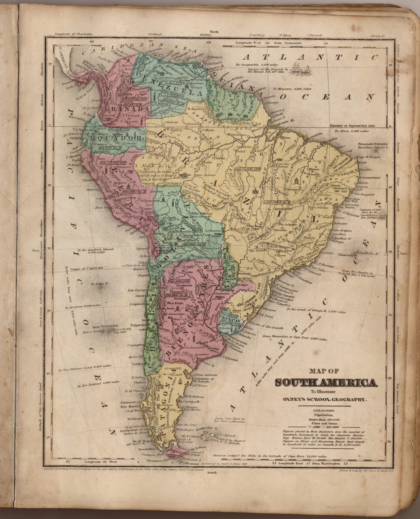
Map of South America to illustrate Olney's school geography
-
Map/Doc
93545
-
Collection
General Map Collection
-
Object Dates
1844 (Creation Date)
2013/7/12 (File Date)
-
People and Organizations
Pratt, Woodford and Co. (Publisher)
Sherman and Smith (Printer)
Galen Greaser (Donor)
Sherman and Smith (Draftsman)
J. Olney (Author)
-
Subjects
Atlas South America
-
Height x Width
12.1 x 9.5 inches
30.7 x 24.1 cm
-
Comments
Donated by Galen Greaser in 2009. Map is part of volume: "Olney's School Atlas". See 93534 for a PDF of this complete atlas.
Related maps
Olney's School Atlas

Print $326.00
- Digital $50.00
Olney's School Atlas
1844
Size 12.3 x 10.0 inches
Map/Doc 93534
Part of: General Map Collection
Flight Mission No. CRK-8P, Frame 105, Refugio County

Print $20.00
- Digital $50.00
Flight Mission No. CRK-8P, Frame 105, Refugio County
1956
Size 18.2 x 22.0 inches
Map/Doc 86966
Flight Mission No. DAG-2T, Frame 101, Matagorda County

Print $20.00
- Digital $50.00
Flight Mission No. DAG-2T, Frame 101, Matagorda County
1957
Size 18.6 x 18.3 inches
Map/Doc 86444
Hutchinson County Rolled Sketch 44-8

Print $20.00
- Digital $50.00
Hutchinson County Rolled Sketch 44-8
2002
Size 24.0 x 36.0 inches
Map/Doc 77544
Reagan County Rolled Sketch 17A

Print $20.00
- Digital $50.00
Reagan County Rolled Sketch 17A
1948
Size 33.8 x 32.4 inches
Map/Doc 9813
Matagorda County Rolled Sketch 37A

Print $40.00
- Digital $50.00
Matagorda County Rolled Sketch 37A
Size 48.7 x 41.1 inches
Map/Doc 10195
Flight Mission No. BRE-2P, Frame 36, Nueces County

Print $20.00
- Digital $50.00
Flight Mission No. BRE-2P, Frame 36, Nueces County
1956
Size 18.5 x 22.7 inches
Map/Doc 86738
Photo Index of Texas Coast - Sheet 2 of 6

Print $20.00
- Digital $50.00
Photo Index of Texas Coast - Sheet 2 of 6
1954
Size 20.0 x 24.0 inches
Map/Doc 83440
Hood County Sketch File 23

Print $20.00
- Digital $50.00
Hood County Sketch File 23
Size 24.5 x 18.6 inches
Map/Doc 11780
Presidio County Rolled Sketch 5

Print $20.00
- Digital $50.00
Presidio County Rolled Sketch 5
Size 23.1 x 22.2 inches
Map/Doc 7329
Ector County Rolled Sketch 9

Print $20.00
- Digital $50.00
Ector County Rolled Sketch 9
1940
Size 39.1 x 43.0 inches
Map/Doc 8837
Haskell County Rolled Sketch 5

Print $20.00
- Digital $50.00
Haskell County Rolled Sketch 5
1858
Size 30.0 x 39.0 inches
Map/Doc 6165
Wichita County Sketch File 5

Print $14.00
- Digital $50.00
Wichita County Sketch File 5
Size 8.2 x 14.5 inches
Map/Doc 40038
You may also like
Flight Mission No. DQN-5K, Frame 51, Calhoun County

Print $20.00
- Digital $50.00
Flight Mission No. DQN-5K, Frame 51, Calhoun County
1953
Size 18.6 x 22.2 inches
Map/Doc 84396
Map of Atascosa Co.

Print $40.00
- Digital $50.00
Map of Atascosa Co.
1894
Size 49.4 x 46.6 inches
Map/Doc 4794
[Map of Denton County]
![4529, [Map of Denton County], General Map Collection](https://historictexasmaps.com/wmedia_w700/maps/4529-1.tif.jpg)
Print $20.00
- Digital $50.00
[Map of Denton County]
1853
Size 24.5 x 29.1 inches
Map/Doc 4529
Dimmit County Sketch File 31

Print $20.00
- Digital $50.00
Dimmit County Sketch File 31
1894
Size 12.7 x 17.3 inches
Map/Doc 11352
Starr County Working Sketch 10

Print $20.00
- Digital $50.00
Starr County Working Sketch 10
1940
Size 38.1 x 32.4 inches
Map/Doc 63926
Cass County Working Sketch 9

Print $20.00
- Digital $50.00
Cass County Working Sketch 9
1937
Size 28.4 x 32.7 inches
Map/Doc 67912

Galveston County Sketch File 44

Print $20.00
- Digital $50.00
Galveston County Sketch File 44
1959
Size 25.2 x 38.8 inches
Map/Doc 10456

A Chart of the Internal Part of Louisiana

Print $20.00
A Chart of the Internal Part of Louisiana
1807
Size 19.2 x 16.5 inches
Map/Doc 79310
Scurry County Rolled Sketch 13

Print $20.00
- Digital $50.00
Scurry County Rolled Sketch 13
2002
Size 19.4 x 19.2 inches
Map/Doc 76417
Flight Mission No. CGI-1N, Frame 185, Cameron County

Print $20.00
- Digital $50.00
Flight Mission No. CGI-1N, Frame 185, Cameron County
1955
Size 18.6 x 22.2 inches
Map/Doc 84520