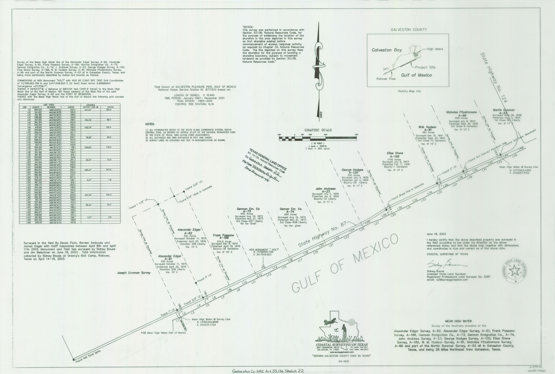
Galveston County NRC Article 33.136 Sketch 22
Mean High Water Survey of the Southerly Shoreline of A-62, A-61, A-166, A-73, A-74, A-23, A-120, A-188, A-81, A-66 and part of A-53
-
Map/Doc
78661
-
Collection
General Map Collection
-
Object Dates
2003/6/18 (Creation Date)
2003/7/29 (File Date)
-
People and Organizations
Coastal Surveying of Texas (Publisher)
Coastal Surveying of Texas (Printer)
Sidney Bouse (Surveyor/Engineer)
-
Counties
Galveston
-
Subjects
Surveying CBS
-
Height x Width
24.2 x 36.0 inches
61.5 x 91.4 cm
-
Medium
multi-page, multi-format
-
Comments
Survey located about 27 miles North 59 degrees East of Galveston, Texas.
One or more items in this file were formerly filed in another file. They have been reunited in this file with their original grouping. The old name on these sheets has been cros
Part of: General Map Collection
Jeff Davis County Texas

Print $20.00
- Digital $50.00
Jeff Davis County Texas
Size 15.9 x 21.3 inches
Map/Doc 4573
[Location Survey of the Southern Kansas Railway, Kiowa Extension from a point in Drake's Location, in Indian Territory 100 miles from south line of Kansas, continuing up Wolf Creek and South Canadian River to Cottonwood Creek in Hutchinson County]
![88842, [Location Survey of the Southern Kansas Railway, Kiowa Extension from a point in Drake's Location, in Indian Territory 100 miles from south line of Kansas, continuing up Wolf Creek and South Canadian River to Cottonwood Creek in Hutchinson County], General Map Collection](https://historictexasmaps.com/wmedia_w700/maps/88842.tif.jpg)
Print $20.00
- Digital $50.00
[Location Survey of the Southern Kansas Railway, Kiowa Extension from a point in Drake's Location, in Indian Territory 100 miles from south line of Kansas, continuing up Wolf Creek and South Canadian River to Cottonwood Creek in Hutchinson County]
1886
Size 39.0 x 42.0 inches
Map/Doc 88842
Dallam County

Print $40.00
- Digital $50.00
Dallam County
1901
Size 44.3 x 56.3 inches
Map/Doc 93459
Jackson County Sketch File 15

Print $13.00
- Digital $50.00
Jackson County Sketch File 15
Size 13.5 x 8.8 inches
Map/Doc 27662
Terrell County Sketch File 4

Print $12.00
- Digital $50.00
Terrell County Sketch File 4
1881
Map/Doc 12417
Flight Mission No. DQO-8K, Frame 85, Galveston County

Print $20.00
- Digital $50.00
Flight Mission No. DQO-8K, Frame 85, Galveston County
1952
Size 18.7 x 22.5 inches
Map/Doc 85187
[Surveys along the Red River]
![5, [Surveys along the Red River], General Map Collection](https://historictexasmaps.com/wmedia_w700/maps/5.tif.jpg)
Print $2.00
- Digital $50.00
[Surveys along the Red River]
Size 14.1 x 5.6 inches
Map/Doc 5
Maps of Gulf Intracoastal Waterway, Texas - Sabine River to the Rio Grande and connecting waterways including ship channels

Print $20.00
- Digital $50.00
Maps of Gulf Intracoastal Waterway, Texas - Sabine River to the Rio Grande and connecting waterways including ship channels
1966
Size 14.6 x 20.8 inches
Map/Doc 61993
Titus County Sketch File 5

Print $4.00
- Digital $50.00
Titus County Sketch File 5
1853
Size 11.7 x 8.2 inches
Map/Doc 38138
Deaf Smith County

Print $40.00
- Digital $50.00
Deaf Smith County
1926
Size 41.4 x 54.3 inches
Map/Doc 1816
Jackson County Boundary File 3

Print $10.00
- Digital $50.00
Jackson County Boundary File 3
Size 10.9 x 8.7 inches
Map/Doc 55455
Webb County Sketch File 13b

Print $3.00
- Digital $50.00
Webb County Sketch File 13b
1893
Size 14.0 x 9.8 inches
Map/Doc 39803
You may also like
Field Notes of Mercer's Colony, Robertson, Nac[a]gdoches, Fannin, & Lamar Counties.
![1953, Field Notes of Mercer's Colony, Robertson, Nac[a]gdoches, Fannin, & Lamar Counties., General Map Collection](https://historictexasmaps.com/wmedia_w700/pdf_converted_jpg/qi_pdf_thumbnail_897.jpg)
Print $30.00
- Digital $50.00
Field Notes of Mercer's Colony, Robertson, Nac[a]gdoches, Fannin, & Lamar Counties.
1845
Size 9.5 x 14.8 inches
Map/Doc 1953
Polk County Sketch File 35

Print $8.00
- Digital $50.00
Polk County Sketch File 35
1891
Size 14.2 x 8.7 inches
Map/Doc 34232
Stanton Acres, a Subdivision of Tracts 2 and 3, Block 1; and Tract 1, Block 2]
![91336, Stanton Acres, a Subdivision of Tracts 2 and 3, Block 1; and Tract 1, Block 2], Twichell Survey Records](https://historictexasmaps.com/wmedia_w700/maps/91336-1.tif.jpg)
Print $3.00
- Digital $50.00
Stanton Acres, a Subdivision of Tracts 2 and 3, Block 1; and Tract 1, Block 2]
Size 9.4 x 11.8 inches
Map/Doc 91336
A New Map of Texas

Print $20.00
- Digital $50.00
A New Map of Texas
1841
Size 17.6 x 16.2 inches
Map/Doc 93862
General Highway Map Cochran County, Texas

Print $20.00
- Digital $50.00
General Highway Map Cochran County, Texas
1948
Size 18.7 x 25.6 inches
Map/Doc 92498

Flight Mission No. CRC-2R, Frame 111, Chambers County

Print $20.00
- Digital $50.00
Flight Mission No. CRC-2R, Frame 111, Chambers County
1956
Size 18.4 x 22.3 inches
Map/Doc 84738
Sketch of Section 3, Blk. JW, Showing Quantity East of Each Texas Section

Print $20.00
- Digital $50.00
Sketch of Section 3, Blk. JW, Showing Quantity East of Each Texas Section
Size 34.2 x 8.0 inches
Map/Doc 91985
Flight Mission No. CUG-3P, Frame 160, Kleberg County

Print $20.00
- Digital $50.00
Flight Mission No. CUG-3P, Frame 160, Kleberg County
1956
Size 18.4 x 22.1 inches
Map/Doc 86280
Uvalde County Working Sketch 6

Print $20.00
- Digital $50.00
Uvalde County Working Sketch 6
1940
Size 37.8 x 38.9 inches
Map/Doc 72076
Medina County

Print $40.00
- Digital $50.00
Medina County
1976
Size 50.6 x 40.9 inches
Map/Doc 77370
![94184, Texas [Verso], General Map Collection](https://historictexasmaps.com/wmedia_w700/maps/94184.tif.jpg)