Childress County Sketch File 24
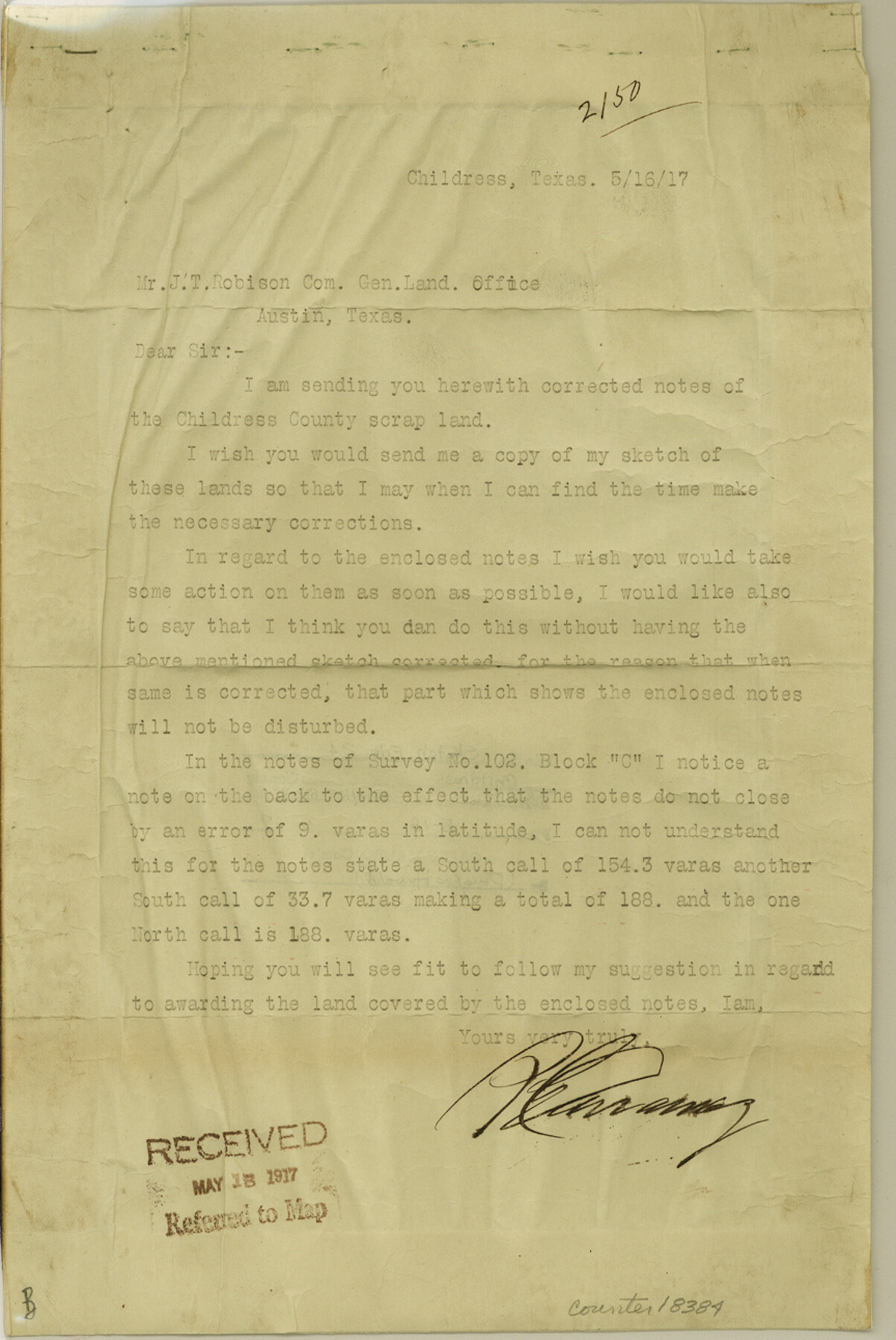
[Letter regarding survey 102, Block C]
-
Map/Doc
18384
-
Collection
General Map Collection
-
Object Dates
1917/5/16 (Creation Date)
1917/5/18 (File Date)
-
People and Organizations
R.G. Carraway (Surveyor/Engineer)
-
Counties
Childress
-
Subjects
Surveying Sketch File
-
Height x Width
12.9 x 8.6 inches
32.8 x 21.8 cm
-
Medium
paper, print
Part of: General Map Collection
Liberty County Working Sketch 19

Print $20.00
- Digital $50.00
Liberty County Working Sketch 19
1940
Size 29.2 x 41.3 inches
Map/Doc 70478
Dickens County Sketch File GW2

Print $8.00
- Digital $50.00
Dickens County Sketch File GW2
Size 14.4 x 9.0 inches
Map/Doc 20938
Crane County Working Sketch 19

Print $20.00
- Digital $50.00
Crane County Working Sketch 19
1958
Size 28.6 x 38.8 inches
Map/Doc 68296
Concho County Working Sketch 9

Print $20.00
- Digital $50.00
Concho County Working Sketch 9
1950
Size 20.0 x 14.6 inches
Map/Doc 68191
Montgomery County Working Sketch 51

Print $20.00
- Digital $50.00
Montgomery County Working Sketch 51
1960
Size 38.7 x 40.4 inches
Map/Doc 71158
Hopkins County Sketch File 5

Print $4.00
- Digital $50.00
Hopkins County Sketch File 5
Size 10.3 x 8.2 inches
Map/Doc 26687

Bowie County Sketch File 7e

Print $10.00
- Digital $50.00
Bowie County Sketch File 7e
1927
Size 10.5 x 8.4 inches
Map/Doc 14867
Hill County Working Sketch Graphic Index

Print $20.00
- Digital $50.00
Hill County Working Sketch Graphic Index
1983
Size 39.8 x 46.9 inches
Map/Doc 76578
Montgomery County Working Sketch 14

Print $20.00
- Digital $50.00
Montgomery County Working Sketch 14
1934
Size 18.5 x 20.1 inches
Map/Doc 71121
Tarrant County Sketch File 17

Print $8.00
- Digital $50.00
Tarrant County Sketch File 17
1860
Size 8.3 x 8.1 inches
Map/Doc 37716
Nueces County Working Sketch 12

Print $20.00
- Digital $50.00
Nueces County Working Sketch 12
2011
Size 22.0 x 42.3 inches
Map/Doc 90047
You may also like
[Parts of Public School Land Blocks 39, 31, C-40, C-42, E. L. & R. R. Blocks H, I]
![91271, [Parts of Public School Land Blocks 39, 31, C-40, C-42, E. L. & R. R. Blocks H, I], Twichell Survey Records](https://historictexasmaps.com/wmedia_w700/maps/91271-1.tif.jpg)
Print $20.00
- Digital $50.00
[Parts of Public School Land Blocks 39, 31, C-40, C-42, E. L. & R. R. Blocks H, I]
Size 14.2 x 19.5 inches
Map/Doc 91271
Flight Mission No. DQO-8K, Frame 142, Galveston County

Print $20.00
- Digital $50.00
Flight Mission No. DQO-8K, Frame 142, Galveston County
1952
Size 18.6 x 22.3 inches
Map/Doc 85204
Map of Lampasas County

Print $20.00
- Digital $50.00
Map of Lampasas County
1856
Size 19.7 x 25.3 inches
Map/Doc 3792
Lubbock Cemetery out of South Part of Survey 3, Block B, T.T. Ry. Co. Amendment of Plat Recorded

Print $20.00
- Digital $50.00
Lubbock Cemetery out of South Part of Survey 3, Block B, T.T. Ry. Co. Amendment of Plat Recorded
Size 22.6 x 24.5 inches
Map/Doc 92794
Concho County Sketch File 37

Print $20.00
- Digital $50.00
Concho County Sketch File 37
1938
Size 18.7 x 29.1 inches
Map/Doc 11162
Anderson County Working Sketch 44

Print $20.00
- Digital $50.00
Anderson County Working Sketch 44
1991
Size 27.7 x 32.3 inches
Map/Doc 67044
Map of Capitol Leagues Situated in Hockley and Lamb Counties, Texas

Print $20.00
- Digital $50.00
Map of Capitol Leagues Situated in Hockley and Lamb Counties, Texas
Size 18.5 x 26.1 inches
Map/Doc 92205
Kent County Working Sketch 20

Print $40.00
- Digital $50.00
Kent County Working Sketch 20
1980
Size 50.7 x 44.1 inches
Map/Doc 70027
McMullen County Sketch File 23

Print $4.00
- Digital $50.00
McMullen County Sketch File 23
1876
Size 10.0 x 8.0 inches
Map/Doc 31379
Lavaca County Sketch File 10

Print $4.00
- Digital $50.00
Lavaca County Sketch File 10
1890
Size 7.5 x 11.5 inches
Map/Doc 29648
Right of Way and Track Map, the Missouri, Kansas and Texas Ry. of Texas - Henrietta Division

Print $20.00
- Digital $50.00
Right of Way and Track Map, the Missouri, Kansas and Texas Ry. of Texas - Henrietta Division
1918
Size 11.8 x 27.0 inches
Map/Doc 64761
Marion County Working Sketch 38

Print $20.00
- Digital $50.00
Marion County Working Sketch 38
1991
Size 35.5 x 39.9 inches
Map/Doc 70814