Castro County Sketch File 1a
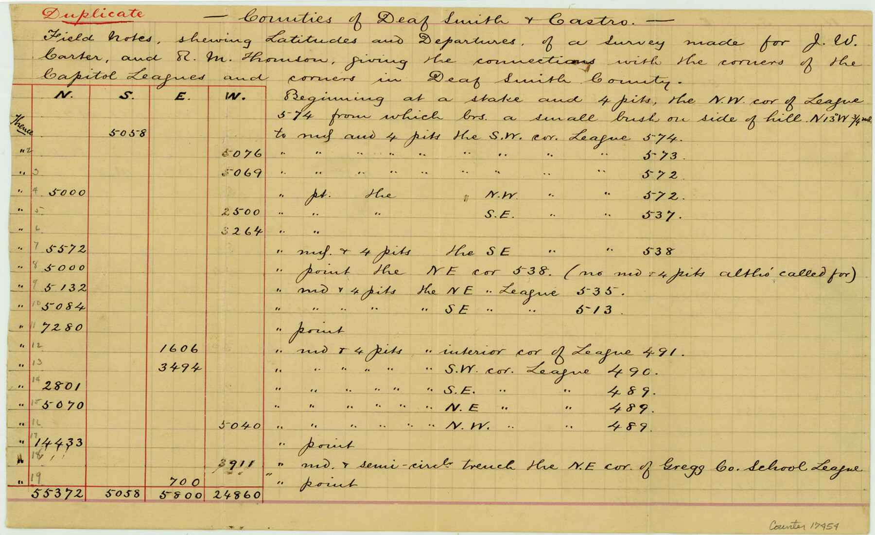
[Field notes showing latitudes and departures of a survey made for J.W. Carter and R.M. Thomson, giving the connections with the corners of the Capitol Leagues and corners in Deaf Smith County]
-
Map/Doc
17454
-
Collection
General Map Collection
-
Object Dates
1890/4/12 (Survey Date)
1890/5/8 (File Date)
-
People and Organizations
David B. Braid (Surveyor/Engineer)
Lewis Breeding (Chainman/Field Personnel)
Plaz. Cano (Chainman/Field Personnel)
-
Counties
Castro Deaf Smith
-
Subjects
Surveying Sketch File
-
Height x Width
8.6 x 14.0 inches
21.8 x 35.6 cm
-
Medium
paper, manuscript
Part of: General Map Collection
Flight Mission No. BRE-1P, Frame 142, Nueces County

Print $20.00
- Digital $50.00
Flight Mission No. BRE-1P, Frame 142, Nueces County
1956
Size 18.4 x 22.3 inches
Map/Doc 86702

Colorado River, Buecher State Park

Print $4.00
- Digital $50.00
Colorado River, Buecher State Park
1934
Size 20.8 x 11.6 inches
Map/Doc 65324
Austin County Sketch File 2

Print $4.00
- Digital $50.00
Austin County Sketch File 2
Size 8.2 x 6.3 inches
Map/Doc 13855
Hardeman County Sketch File 15

Print $20.00
- Digital $50.00
Hardeman County Sketch File 15
Size 18.9 x 17.9 inches
Map/Doc 11627
The Coast of Texas

Print $20.00
- Digital $50.00
The Coast of Texas
1844
Size 18.3 x 27.1 inches
Map/Doc 72699
Maverick County Sketch File 23

Print $7.00
- Digital $50.00
Maverick County Sketch File 23
Size 9.1 x 8.5 inches
Map/Doc 31142
Callahan County Rolled Sketch 5

Print $40.00
- Digital $50.00
Callahan County Rolled Sketch 5
Size 52.0 x 44.1 inches
Map/Doc 5382
Flight Mission No. CRC-3R, Frame 37, Chambers County

Print $20.00
- Digital $50.00
Flight Mission No. CRC-3R, Frame 37, Chambers County
1956
Size 18.6 x 22.4 inches
Map/Doc 84810
Copy of Surveyor's Field Book, Morris Browning - In Blocks 7, 5 & 4, I&GNRRCo., Hutchinson and Carson Counties, Texas

Print $2.00
- Digital $50.00
Copy of Surveyor's Field Book, Morris Browning - In Blocks 7, 5 & 4, I&GNRRCo., Hutchinson and Carson Counties, Texas
1888
Size 6.9 x 8.8 inches
Map/Doc 62260
Wilbarger Co.

Print $40.00
- Digital $50.00
Wilbarger Co.
1907
Size 48.8 x 39.8 inches
Map/Doc 63127
Collin County Boundary File 4 and 4a

Print $160.00
- Digital $50.00
Collin County Boundary File 4 and 4a
Size 11.9 x 8.5 inches
Map/Doc 51691
You may also like
Map of Marion County

Print $20.00
- Digital $50.00
Map of Marion County
1920
Size 29.2 x 42.2 inches
Map/Doc 78405
Nueces County Sketch File 58

Print $162.00
- Digital $50.00
Nueces County Sketch File 58
1981
Size 11.2 x 8.5 inches
Map/Doc 32920
Brazoria County Sketch File 57

Print $10.00
- Digital $50.00
Brazoria County Sketch File 57
1940
Size 8.7 x 6.3 inches
Map/Doc 15377
Current Miscellaneous File 107

Print $4.00
- Digital $50.00
Current Miscellaneous File 107
1994
Size 9.2 x 12.4 inches
Map/Doc 74707

Culberson County Working Sketch 84

Print $20.00
- Digital $50.00
Culberson County Working Sketch 84
1980
Size 43.5 x 42.9 inches
Map/Doc 68538
Reeves County Working Sketch 34

Print $40.00
- Digital $50.00
Reeves County Working Sketch 34
1970
Size 37.9 x 48.9 inches
Map/Doc 63477

Yoakum County

Print $20.00
- Digital $50.00
Yoakum County
1902
Size 46.1 x 36.6 inches
Map/Doc 63138
Flight Mission No. DCL-6C, Frame 28, Kenedy County

Print $20.00
- Digital $50.00
Flight Mission No. DCL-6C, Frame 28, Kenedy County
1943
Size 18.7 x 22.4 inches
Map/Doc 85885
San Jacinto River, Proposed Dam Site/Huntsville State Park

Print $6.00
- Digital $50.00
San Jacinto River, Proposed Dam Site/Huntsville State Park
1937
Size 30.2 x 26.6 inches
Map/Doc 65151
Motley County Sketch File B3 (N)

Print $10.00
- Digital $50.00
Motley County Sketch File B3 (N)
1900
Size 6.5 x 11.9 inches
Map/Doc 31974