Austin County Sketch File 2
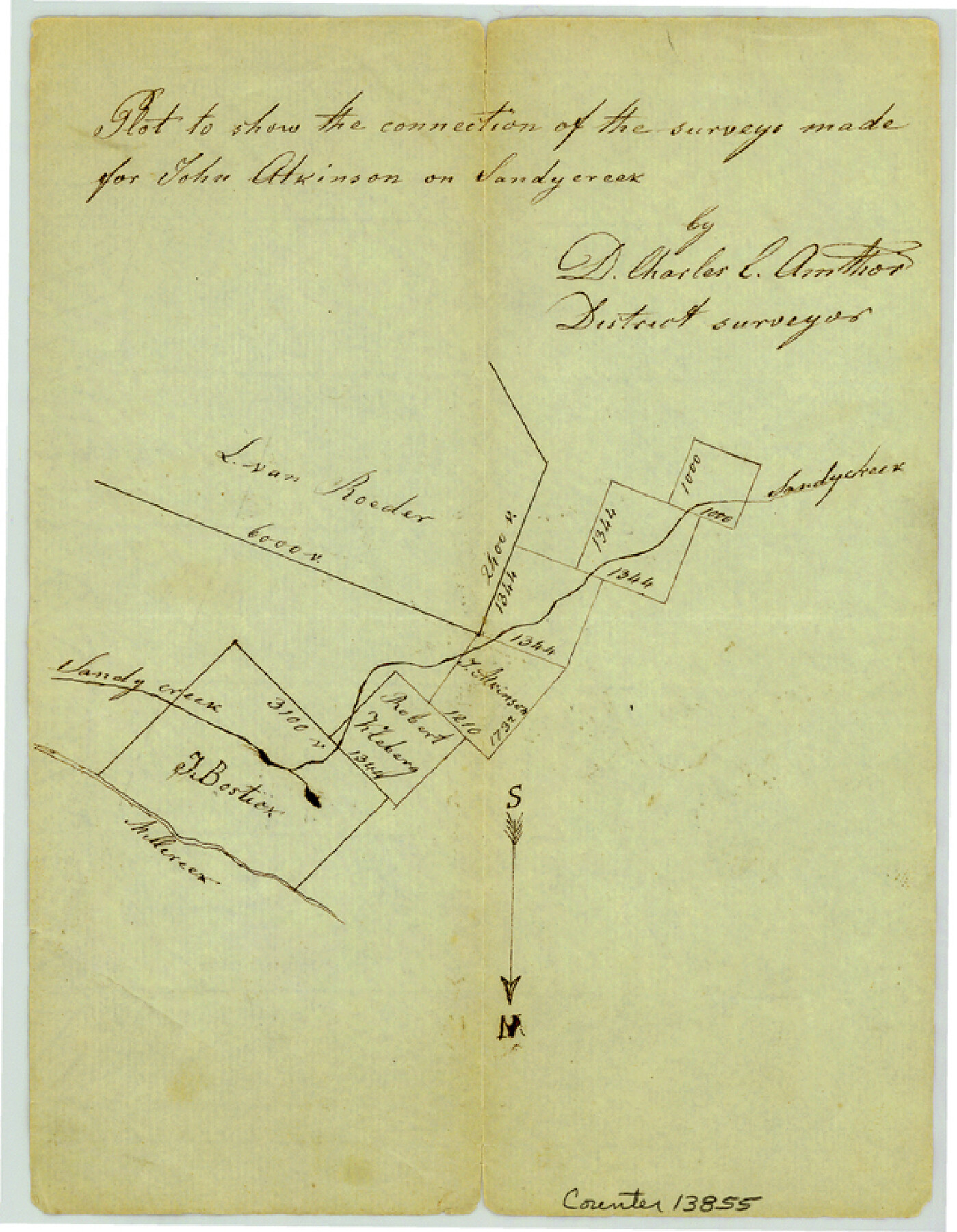
Plat to show the connection of the surveys made for John Atkinson on Sandy Creek
-
Map/Doc
13855
-
Collection
General Map Collection
-
Object Dates
1849/2/22 (File Date)
-
People and Organizations
D. Charles Amthor (Surveyor/Engineer)
-
Counties
Austin
-
Subjects
Surveying Sketch File
-
Height x Width
8.2 x 6.3 inches
20.8 x 16.0 cm
-
Medium
paper, manuscript
-
Features
Sandy Creek
Mill Creek
Part of: General Map Collection
Cameron County

Print $20.00
- Digital $50.00
Cameron County
1913
Size 30.0 x 33.8 inches
Map/Doc 1793
Childress County Rolled Sketch 10

Print $20.00
- Digital $50.00
Childress County Rolled Sketch 10
1940
Size 43.6 x 12.0 inches
Map/Doc 8601
Nueces County Rolled Sketch 51A

Print $20.00
- Digital $50.00
Nueces County Rolled Sketch 51A
1978
Size 27.6 x 39.1 inches
Map/Doc 6890
Bell County Sketch File 6

Print $4.00
- Digital $50.00
Bell County Sketch File 6
Size 6.3 x 7.7 inches
Map/Doc 14373
Anderson County Sketch File 9

Print $8.00
- Digital $50.00
Anderson County Sketch File 9
Size 12.5 x 8.2 inches
Map/Doc 12761
Flight Mission No. DAG-21K, Frame 89, Matagorda County

Print $20.00
- Digital $50.00
Flight Mission No. DAG-21K, Frame 89, Matagorda County
1952
Size 18.5 x 22.3 inches
Map/Doc 86418
Presidio County Rolled Sketch 28

Print $40.00
- Digital $50.00
Presidio County Rolled Sketch 28
1886
Size 25.7 x 120.0 inches
Map/Doc 76139
San Augustine Co.

Print $20.00
- Digital $50.00
San Augustine Co.
1949
Size 45.7 x 28.6 inches
Map/Doc 77414
Val Verde County

Print $20.00
- Digital $50.00
Val Verde County
1944
Size 40.8 x 37.7 inches
Map/Doc 78448
Amistad International Reservoir on Rio Grande 69

Print $20.00
- Digital $50.00
Amistad International Reservoir on Rio Grande 69
1949
Size 28.4 x 39.4 inches
Map/Doc 73355
Roberts County Working Sketch 47

Print $20.00
- Digital $50.00
Roberts County Working Sketch 47
1996
Size 19.6 x 34.7 inches
Map/Doc 63573
Upper Galveston Bay, Houston Ship Channel, Dollar Pt. to Atkinson I.

Print $40.00
- Digital $50.00
Upper Galveston Bay, Houston Ship Channel, Dollar Pt. to Atkinson I.
1976
Size 49.3 x 36.5 inches
Map/Doc 69897
You may also like

[Sketch of Blocks Z and 194, showing tie lines with Runnels County School Land survey]
![91665, [Sketch of Blocks Z and 194, showing tie lines with Runnels County School Land survey], Twichell Survey Records](https://historictexasmaps.com/wmedia_w700/maps/91665-1.tif.jpg)
Print $20.00
- Digital $50.00
[Sketch of Blocks Z and 194, showing tie lines with Runnels County School Land survey]
Size 21.5 x 15.5 inches
Map/Doc 91665
Trails made and routes used by the Fourth U.S. Cavalry under command of General R.S. Mackenzie in its operations against hostile indians in Texas, Indian-Territory (now Oklahoma), New Mexico and Old Mexico during the period of 1871-2-3-4 and 5

Print $20.00
- Digital $50.00
Trails made and routes used by the Fourth U.S. Cavalry under command of General R.S. Mackenzie in its operations against hostile indians in Texas, Indian-Territory (now Oklahoma), New Mexico and Old Mexico during the period of 1871-2-3-4 and 5
1927
Size 37.0 x 34.2 inches
Map/Doc 62973
Potter County Sketch File 12

Print $4.00
- Digital $50.00
Potter County Sketch File 12
1890
Size 6.0 x 8.7 inches
Map/Doc 34399
Wharton County Working Sketch 6

Print $20.00
- Digital $50.00
Wharton County Working Sketch 6
1990
Size 24.7 x 21.1 inches
Map/Doc 72470
Flight Mission No. DQN-1K, Frame 120, Calhoun County

Print $20.00
- Digital $50.00
Flight Mission No. DQN-1K, Frame 120, Calhoun County
1953
Size 18.5 x 22.2 inches
Map/Doc 84186
[Blocks O3 and O4 and Capitol Leagues in the vicinity]
![90391, [Blocks O3 and O4 and Capitol Leagues in the vicinity], Twichell Survey Records](https://historictexasmaps.com/wmedia_w700/maps/90391-1.tif.jpg)
Print $2.00
- Digital $50.00
[Blocks O3 and O4 and Capitol Leagues in the vicinity]
Size 8.4 x 10.5 inches
Map/Doc 90391
Brewster County Rolled Sketch 144A

Print $40.00
- Digital $50.00
Brewster County Rolled Sketch 144A
Size 53.4 x 43.5 inches
Map/Doc 9195
Jones County Working Sketch 2

Print $20.00
- Digital $50.00
Jones County Working Sketch 2
1928
Size 19.9 x 22.2 inches
Map/Doc 66640
Kerr County Sketch File 20

Print $22.00
- Digital $50.00
Kerr County Sketch File 20
1951
Size 12.9 x 18.3 inches
Map/Doc 28890
Bexar County Sketch File 42

Print $4.00
- Digital $50.00
Bexar County Sketch File 42
1882
Size 10.6 x 8.7 inches
Map/Doc 14518
Blanco County Working Sketch 41

Print $20.00
- Digital $50.00
Blanco County Working Sketch 41
1986
Size 28.4 x 25.2 inches
Map/Doc 67401