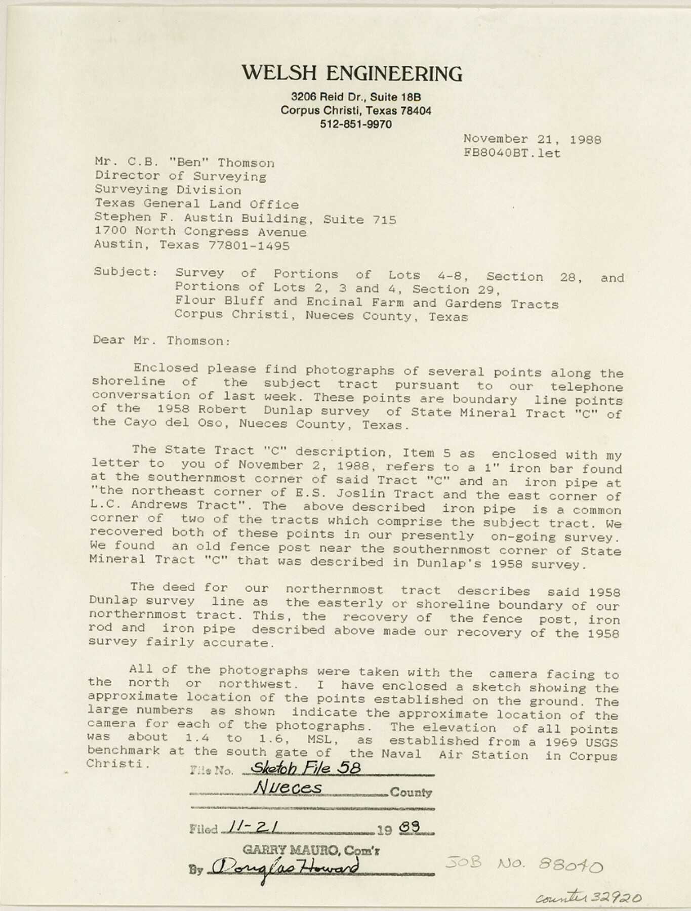
Nueces County Sketch File 58
Flour Bluff and Encinal Farm and Garden Tracts, Nueces County, Texas
-
Map/Doc
32920
-
Collection
General Map Collection
-
Object Dates
12/31/1981 (Creation Date)
11/1988 (Creation Date)
11/3/1988 (File Date)
11/21/1988
11/2/1988 (Correspondence Date)
10/1858 (Survey Date)
1/12/1989 (Correspondence Date)
12/30/1988 (Correspondence Date)
12/29/1988 (Correspondence Date)
1/18/1989 (Correspondence Date)
12/16/1988 (Correspondence Date)
12/29/1988 (Creation Date)
10/1958 (Survey Date)
-
People and Organizations
Nixon M. Welsh (Surveyor/Engineer)
William W. Green (Surveyor/Engineer)
Richard Lemley (Chainman/Field Personnel)
Fernado [sic] Trevino (Chainman/Field Personnel)
John Urtiago (Chainman/Field Personnel)
Robert M. Dunlap (Surveyor/Engineer)
George M. Pyle (Surveyor/Engineer)
K.G. Davis (Draftsman)
-
Counties
Nueces
-
Subjects
Surveying Sketch File
-
Height x Width
11.2 x 8.5 inches
28.5 x 21.6 cm
-
Medium
multi-page, multi-format
-
Features
Argonne Street
Sundeen Jr. High School
South Padre Island Drive
Hana Jr. High School
Oso Park
Smith School
Holly Road
U.S. Naval Radio Facility
Saratoga Boulevard
U.S. Government Railroad
Peary Place
Encinal Farm
McArdle Road
Porter Street
Wallace Street
Woodlawn School
Barnhart Street
Decatur Street
Baylark Street
Sea Lane Drive
South Bay Drive
Harbor Village
Sea Breeze
Anchor Harbor
Sahara Crive
Alameda Drive
Del Oso Road
Pharoa Crive
Pelican Bay Estates
Ocean Drive
Corpus Christi
Cayo del Oso
South Padre Island Drive
Ennis Joslin Road
Oso Creek
Laguna Madre
Cayo del Oso
Oso Bay
Blind Oso
Edgewater Terrace
University of Corpus Christi
Guth Park
Oso Municipal Golf Course
Flour Bluff
Corpus Christi Bay
Lexington Boulevard
University Heights
Ward Island
Koolside Park
South Alameda [Road]
Montclair School
Glenmore Street
Kenthner Street
Paloma Street
Cullen Place Jr. High School
Airline Road
Cullen Park
Part of: General Map Collection
Medina County Working Sketch 27

Print $20.00
- Digital $50.00
Medina County Working Sketch 27
1985
Size 22.8 x 24.8 inches
Map/Doc 70942
Sutton County Boundary File 4

Print $20.00
- Digital $50.00
Sutton County Boundary File 4
Size 14.2 x 8.8 inches
Map/Doc 59035
Montague County Sketch File 19

Print $6.00
- Digital $50.00
Montague County Sketch File 19
1924
Size 11.2 x 8.5 inches
Map/Doc 31748
Liberty County Sketch File 9

Print $8.00
- Digital $50.00
Liberty County Sketch File 9
1857
Size 8.0 x 8.1 inches
Map/Doc 29900
Bee County Sketch File 10

Print $4.00
- Digital $50.00
Bee County Sketch File 10
Size 12.8 x 7.9 inches
Map/Doc 14291
Ector County Working Sketch 18

Print $20.00
- Digital $50.00
Ector County Working Sketch 18
1957
Size 42.0 x 39.1 inches
Map/Doc 68861

Hutchinson County Working Sketch 12

Print $20.00
- Digital $50.00
Hutchinson County Working Sketch 12
1925
Size 20.6 x 29.9 inches
Map/Doc 66370
Jackson County Sketch File 28

Print $38.00
- Digital $50.00
Jackson County Sketch File 28
1945
Size 14.2 x 8.7 inches
Map/Doc 27706
Presidio County Rolled Sketch 62

Print $20.00
- Digital $50.00
Presidio County Rolled Sketch 62
1916
Size 39.5 x 21.7 inches
Map/Doc 78468
Wharton County Working Sketch 13

Print $20.00
- Digital $50.00
Wharton County Working Sketch 13
1968
Size 38.5 x 36.3 inches
Map/Doc 72477
Upton County Working Sketch 60

Print $20.00
- Digital $50.00
Upton County Working Sketch 60
2012
Size 34.2 x 32.1 inches
Map/Doc 93387
You may also like
1988 Land Use - El Paso, Ciudad Juarez and Vicinity

Print $20.00
- Digital $50.00
1988 Land Use - El Paso, Ciudad Juarez and Vicinity
1988
Size 34.2 x 25.1 inches
Map/Doc 87369
Dickens County Working Sketch 4

Print $20.00
- Digital $50.00
Dickens County Working Sketch 4
1914
Size 27.9 x 18.8 inches
Map/Doc 68651
Liberty County Working Sketch 79

Print $40.00
- Digital $50.00
Liberty County Working Sketch 79
1981
Size 63.7 x 41.4 inches
Map/Doc 70539
Zapata County Sketch File 13

Print $4.00
- Digital $50.00
Zapata County Sketch File 13
1930
Size 11.3 x 8.8 inches
Map/Doc 40952
Duval County Rolled Sketch 25

Print $20.00
- Digital $50.00
Duval County Rolled Sketch 25
1944
Size 31.3 x 27.7 inches
Map/Doc 8813
Palo Pinto County Rolled Sketch 2

Print $20.00
- Digital $50.00
Palo Pinto County Rolled Sketch 2
1917
Size 37.5 x 43.8 inches
Map/Doc 9669
Marion County Working Sketch 14

Print $20.00
- Digital $50.00
Marion County Working Sketch 14
1956
Size 25.1 x 25.0 inches
Map/Doc 70790
[Map of Chicago, Rock Island & Texas Railway through Tarrant County, Texas]
![64412, [Map of Chicago, Rock Island & Texas Railway through Tarrant County, Texas], General Map Collection](https://historictexasmaps.com/wmedia_w700/maps/64412.tif.jpg)
Print $40.00
- Digital $50.00
[Map of Chicago, Rock Island & Texas Railway through Tarrant County, Texas]
1893
Size 22.9 x 122.0 inches
Map/Doc 64412
Current Miscellaneous File 69

Print $10.00
- Digital $50.00
Current Miscellaneous File 69
1916
Size 11.2 x 8.8 inches
Map/Doc 74145
Map of Denton County

Print $20.00
- Digital $50.00
Map of Denton County
1897
Size 43.4 x 40.2 inches
Map/Doc 4720
Flight Mission No. BRA-7M, Frame 186, Jefferson County

Print $20.00
- Digital $50.00
Flight Mission No. BRA-7M, Frame 186, Jefferson County
1953
Size 18.4 x 22.2 inches
Map/Doc 85554
Padre Island National Seashore, Texas - Dependent Resurvey

Print $4.00
- Digital $50.00
Padre Island National Seashore, Texas - Dependent Resurvey
2001
Size 18.3 x 24.4 inches
Map/Doc 60545