Brazos County Sketch File 2
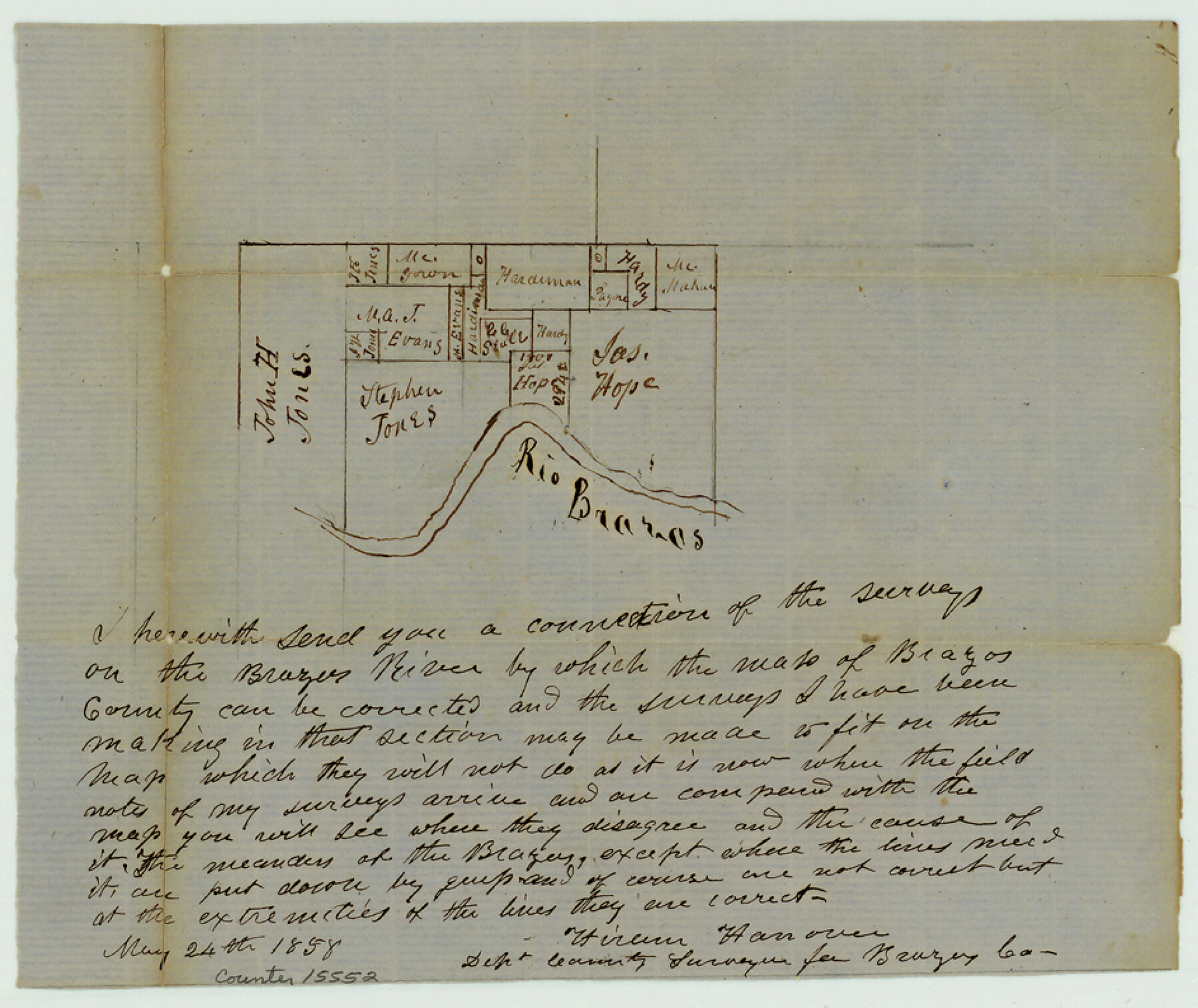
[Sketch of surveys on north bank of Brazos River, south of Bryan]
-
Map/Doc
15552
-
Collection
General Map Collection
-
Object Dates
1858/5/24 (Creation Date)
1858/6/8 (File Date)
-
People and Organizations
Hiram Hanover (Surveyor/Engineer)
-
Counties
Brazos
-
Subjects
Surveying Sketch File
-
Height x Width
7.9 x 9.4 inches
20.1 x 23.9 cm
-
Medium
paper, manuscript
-
Features
Rio Brazos
Part of: General Map Collection
Wichita County Sketch File 16

Print $4.00
- Digital $50.00
Wichita County Sketch File 16
1890
Size 12.9 x 8.9 inches
Map/Doc 40095
Galveston / Texas City, Texas Street Map

Galveston / Texas City, Texas Street Map
2000
Size 36.1 x 24.2 inches
Map/Doc 96855
Newton County Aerial Photograph Index Sheet 1

Print $20.00
- Digital $50.00
Newton County Aerial Photograph Index Sheet 1
1953
Size 23.8 x 18.7 inches
Map/Doc 83730
Goliad County Sketch File 42a

Print $4.00
- Digital $50.00
Goliad County Sketch File 42a
1845
Size 13.3 x 8.2 inches
Map/Doc 24353
Red River County Working Sketch 66

Print $20.00
- Digital $50.00
Red River County Working Sketch 66
1974
Size 44.0 x 32.5 inches
Map/Doc 72049
Goliad County Sketch File 1

Print $24.00
- Digital $50.00
Goliad County Sketch File 1
1857
Size 12.5 x 7.5 inches
Map/Doc 24211
Map of Hopkins County

Print $20.00
- Digital $50.00
Map of Hopkins County
1872
Size 17.5 x 17.9 inches
Map/Doc 4567
Map of Newton Co.

Print $20.00
- Digital $50.00
Map of Newton Co.
1905
Size 47.5 x 38.9 inches
Map/Doc 5020
Upshur County Working Sketch 15, revised

Print $20.00
- Digital $50.00
Upshur County Working Sketch 15, revised
1996
Size 43.3 x 37.4 inches
Map/Doc 78217
Right of Way and Track Map, Texas & New Orleans R.R. operated by the T. & N. O. R.R. Co., Rusk Branch

Print $40.00
- Digital $50.00
Right of Way and Track Map, Texas & New Orleans R.R. operated by the T. & N. O. R.R. Co., Rusk Branch
1918
Size 24.7 x 56.2 inches
Map/Doc 64243
Chambers County Sketch File 22

Print $8.00
- Digital $50.00
Chambers County Sketch File 22
Size 12.2 x 7.6 inches
Map/Doc 17594
Nolan County Working Sketch 6

Print $20.00
- Digital $50.00
Nolan County Working Sketch 6
1950
Size 27.2 x 26.0 inches
Map/Doc 71297
You may also like
Map of Lands surveyed for the Deaf & Dumb Asylum on the head waters of the Leon River

Print $20.00
- Digital $50.00
Map of Lands surveyed for the Deaf & Dumb Asylum on the head waters of the Leon River
1857
Size 13.3 x 17.1 inches
Map/Doc 2209
[T. & G. Ry. Main Line, Texas, Right of Way Map, Center to Gary]
![64572, [T. & G. Ry. Main Line, Texas, Right of Way Map, Center to Gary], General Map Collection](https://historictexasmaps.com/wmedia_w700/maps/64572-1.tif.jpg)
Print $40.00
- Digital $50.00
[T. & G. Ry. Main Line, Texas, Right of Way Map, Center to Gary]
1917
Size 31.9 x 104.6 inches
Map/Doc 64572
Texas Hill Country Trail Region

Texas Hill Country Trail Region
Size 18.1 x 24.2 inches
Map/Doc 96872
Map of Ramsey State Farm

Print $20.00
- Digital $50.00
Map of Ramsey State Farm
1934
Size 30.3 x 38.0 inches
Map/Doc 94284
Map of Ellis Farm Unit, Texas Department of Corrections, Walker County, Texas

Print $20.00
- Digital $50.00
Map of Ellis Farm Unit, Texas Department of Corrections, Walker County, Texas
Size 36.3 x 27.1 inches
Map/Doc 2284
Map of Stephens County

Print $20.00
- Digital $50.00
Map of Stephens County
1879
Size 24.0 x 19.6 inches
Map/Doc 4053
Martin County Sketch File 6

Print $4.00
- Digital $50.00
Martin County Sketch File 6
1914
Size 7.3 x 8.9 inches
Map/Doc 30642
Presidio County Working Sketch 77

Print $20.00
- Digital $50.00
Presidio County Working Sketch 77
1964
Size 36.0 x 39.0 inches
Map/Doc 71754
Flight Mission No. CRC-1R, Frame 155, Chambers County

Print $20.00
- Digital $50.00
Flight Mission No. CRC-1R, Frame 155, Chambers County
1956
Size 18.8 x 22.4 inches
Map/Doc 84717
The Republic County of Montgomery. December 18, 1837

Print $20.00
The Republic County of Montgomery. December 18, 1837
2020
Size 19.9 x 21.7 inches
Map/Doc 96235
Duval County Sketch File 81

Print $18.00
- Digital $50.00
Duval County Sketch File 81
Size 11.2 x 8.8 inches
Map/Doc 21507
Harrison County Rolled Sketch 4

Print $20.00
- Digital $50.00
Harrison County Rolled Sketch 4
1938
Size 28.2 x 34.9 inches
Map/Doc 6150