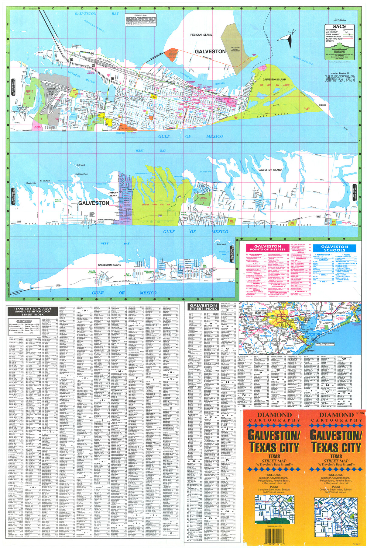
Galveston / Texas City, Texas Street Map
Galveston
-
Map/Doc
96855
-
Collection
General Map Collection
-
Object Dates
2000 (Creation Date)
-
People and Organizations
Diamond Cartography (Publisher)
Mark Lambert (Donor)
Rudy C. Gonzales (Cartographer)
-
Subjects
City
-
Height x Width
36.1 x 24.2 inches
91.7 x 61.5 cm
-
Medium
paper, print
-
Scale
1" = approx. 0.5 miles
-
Comments
For research only. Donated by Mark Lambert in May, 2022. See 96856 for verso.
Related maps

Part of: General Map Collection
Val Verde County Sketch File 30

Print $8.00
- Digital $50.00
Val Verde County Sketch File 30
1933
Size 11.5 x 8.8 inches
Map/Doc 39236
Upton County Rolled Sketch 13

Print $20.00
- Digital $50.00
Upton County Rolled Sketch 13
1926
Size 32.5 x 43.6 inches
Map/Doc 10037
Jefferson County Sketch File 3

Print $8.00
- Digital $50.00
Jefferson County Sketch File 3
1849
Size 8.2 x 7.8 inches
Map/Doc 28097
Flight Mission No. BRE-2P, Frame 130, Nueces County

Print $20.00
- Digital $50.00
Flight Mission No. BRE-2P, Frame 130, Nueces County
1956
Size 18.6 x 22.3 inches
Map/Doc 86803
Hunt County Sketch File 40

Print $4.00
- Digital $50.00
Hunt County Sketch File 40
Size 7.6 x 8.0 inches
Map/Doc 27163
Crockett County Sketch File 29

Print $8.00
- Digital $50.00
Crockett County Sketch File 29
1883
Size 12.5 x 8.1 inches
Map/Doc 19727
Lampasas County Working Sketch 3

Print $20.00
- Digital $50.00
Lampasas County Working Sketch 3
1941
Size 25.0 x 14.6 inches
Map/Doc 70280
Kent County Working Sketch Graphic Index

Print $20.00
- Digital $50.00
Kent County Working Sketch Graphic Index
1971
Size 44.7 x 37.0 inches
Map/Doc 76604

Flight Mission No. BRE-1P, Frame 123, Nueces County

Print $20.00
- Digital $50.00
Flight Mission No. BRE-1P, Frame 123, Nueces County
1956
Size 18.6 x 22.7 inches
Map/Doc 86689
Crosby County Sketch File 1a

Print $6.00
- Digital $50.00
Crosby County Sketch File 1a
1874
Size 11.0 x 14.2 inches
Map/Doc 19987
Starr County Working Sketch 15

Print $20.00
- Digital $50.00
Starr County Working Sketch 15
1971
Size 34.4 x 37.6 inches
Map/Doc 63931
You may also like
Haskell County Rolled Sketch 15

Print $20.00
- Digital $50.00
Haskell County Rolled Sketch 15
1991
Size 12.7 x 18.4 inches
Map/Doc 6173
Intracoastal Waterway in Texas - Corpus Christi to Point Isabel including Arroyo Colorado to Mo. Pac. R.R. Bridge Near Harlingen

Print $20.00
- Digital $50.00
Intracoastal Waterway in Texas - Corpus Christi to Point Isabel including Arroyo Colorado to Mo. Pac. R.R. Bridge Near Harlingen
1934
Size 22.1 x 32.7 inches
Map/Doc 61887
Taylor County Working Sketch 14

Print $20.00
- Digital $50.00
Taylor County Working Sketch 14
1959
Size 26.8 x 21.4 inches
Map/Doc 69624
Haskell County Boundary File 7

Print $40.00
- Digital $50.00
Haskell County Boundary File 7
Size 3.6 x 38.5 inches
Map/Doc 54584
Duval County Sketch File 30

Print $20.00
- Digital $50.00
Duval County Sketch File 30
1932
Size 14.7 x 23.7 inches
Map/Doc 11388
Gulf Intracoastal Waterway, Tex. - Aransas Bay to Corpus Christi Bay - Modified Route of Main Channel/Dredging

Print $20.00
- Digital $50.00
Gulf Intracoastal Waterway, Tex. - Aransas Bay to Corpus Christi Bay - Modified Route of Main Channel/Dredging
1958
Size 31.3 x 42.8 inches
Map/Doc 61899
Throckmorton County Rolled Sketch 6B

Print $20.00
- Digital $50.00
Throckmorton County Rolled Sketch 6B
2004
Size 20.3 x 24.2 inches
Map/Doc 82490
Shelby County Working Sketch 12

Print $40.00
- Digital $50.00
Shelby County Working Sketch 12
1946
Size 53.4 x 36.4 inches
Map/Doc 63865
[Sketch showing the Northwest part of Hale County and the Northeast part of Lamb County]
![93205, [Sketch showing the Northwest part of Hale County and the Northeast part of Lamb County], Twichell Survey Records](https://historictexasmaps.com/wmedia_w700/maps/93205-1.tif.jpg)
Print $40.00
- Digital $50.00
[Sketch showing the Northwest part of Hale County and the Northeast part of Lamb County]
Size 55.3 x 56.7 inches
Map/Doc 93205
Goliad County Working Sketch 13

Print $20.00
- Digital $50.00
Goliad County Working Sketch 13
1943
Size 28.3 x 40.8 inches
Map/Doc 63203
Liberty County Working Sketch 68

Print $20.00
- Digital $50.00
Liberty County Working Sketch 68
1972
Size 27.4 x 24.6 inches
Map/Doc 70528
Rullmann's map of the city of San Antonio

Print $20.00
Rullmann's map of the city of San Antonio
1890
Size 34.6 x 31.0 inches
Map/Doc 93555