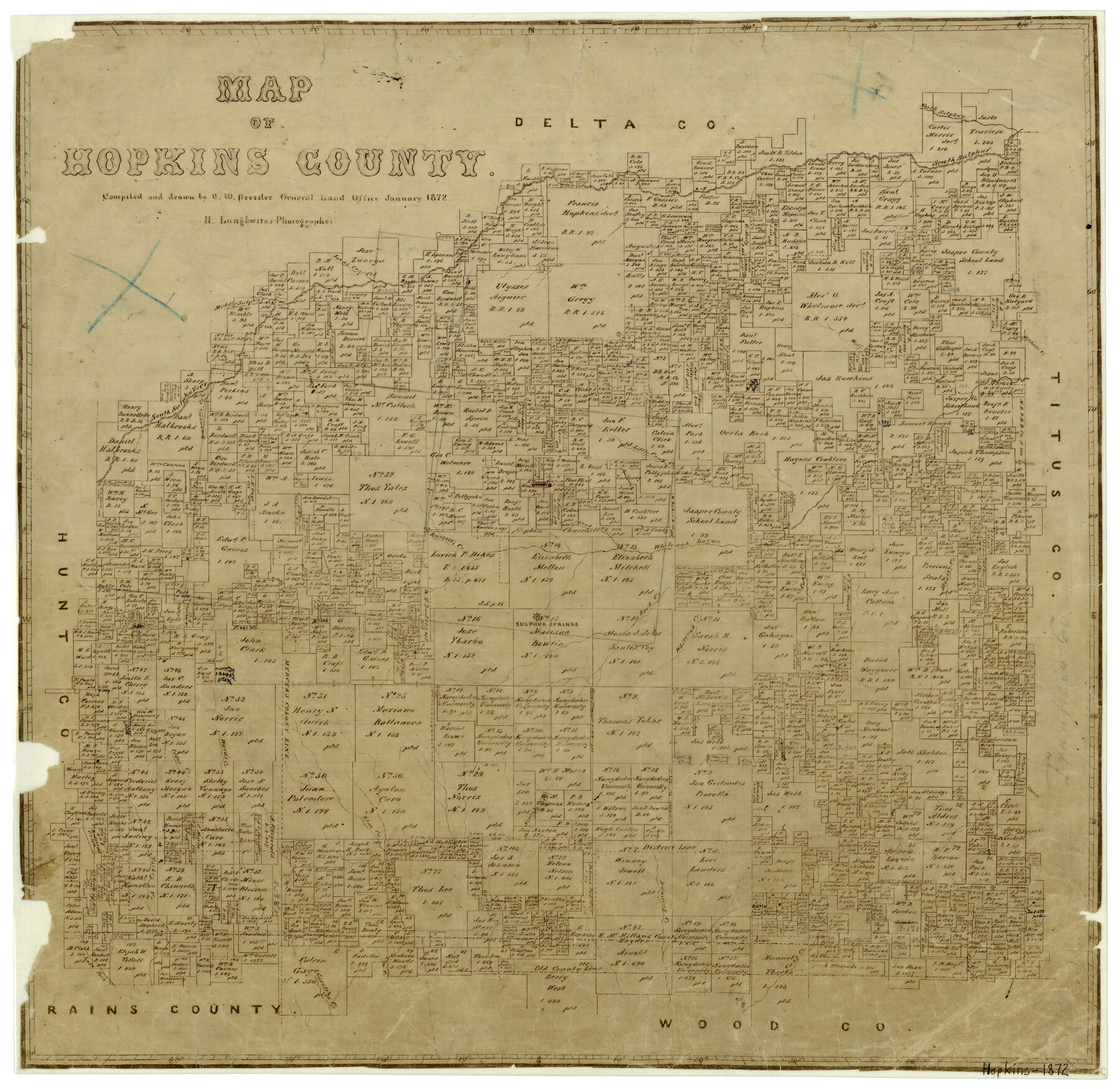
Map of Hopkins County
-
Map/Doc
4567
-
Collection
General Map Collection
-
Object Dates
1/1872 (Creation Date)
-
People and Organizations
Chas. W. Pressler (Draftsman)
Herman Lungkwitz (Draftsman)
-
Counties
Hopkins
-
Subjects
County
-
Height x Width
17.5 x 17.9 inches
44.5 x 45.5 cm
-
Features
Coon Creek
Cany Creek
Ward's Creek
Elm Creek
Turkey Creek
Elm Fork
Garett's Creek
Lake Fork
Running Creek
Whiteoak Bayou
Cypress Creek
Stouts Creek
Cedar Creek
Burke's Creek
Norton's Creek
Big Cypress Creek
Sandy Creek
Middle Sulphur River
Rock Creek
Whiteoak Creek
Cottonwood Creek
Sulphur Springs
Tarrant
Russell's Creek
Brannum Creek
Merrick Creek
Little Cany Creek
Crosstimber Creek
Wolf Pen Creek
Mitchell's Creek
South Sulphur River
North Sulphur River
John's Creek
Part of: General Map Collection
Nueces County Rolled Sketch 71

Print $247.00
Nueces County Rolled Sketch 71
1980
Size 37.9 x 24.7 inches
Map/Doc 6924
Bee County Sketch File 27

Print $8.00
- Digital $50.00
Bee County Sketch File 27
1886
Size 14.3 x 8.8 inches
Map/Doc 14331
Concho County Sketch File 18

Print $32.00
- Digital $50.00
Concho County Sketch File 18
1898
Size 9.1 x 4.4 inches
Map/Doc 19137
Val Verde County Boundary File 1

Print $6.00
- Digital $50.00
Val Verde County Boundary File 1
Size 14.3 x 8.7 inches
Map/Doc 59572
Cottle County Sketch File 11

Print $40.00
- Digital $50.00
Cottle County Sketch File 11
Size 12.9 x 13.3 inches
Map/Doc 19489
[Right of Way & Track Map, The Texas & Pacific Ry. Co. Main Line]
![64678, [Right of Way & Track Map, The Texas & Pacific Ry. Co. Main Line], General Map Collection](https://historictexasmaps.com/wmedia_w700/maps/64678.tif.jpg)
Print $20.00
- Digital $50.00
[Right of Way & Track Map, The Texas & Pacific Ry. Co. Main Line]
Size 11.1 x 18.3 inches
Map/Doc 64678
Brewster County Rolled Sketch 24B

Print $20.00
- Digital $50.00
Brewster County Rolled Sketch 24B
Size 17.2 x 22.4 inches
Map/Doc 5209
Atascosa County Working Sketch 7

Print $3.00
- Digital $50.00
Atascosa County Working Sketch 7
1913
Size 14.0 x 9.4 inches
Map/Doc 67203
Sketch I: Showing the Progress of the Survey in Section No. 9 [Galveston Bay]
![97133, Sketch I: Showing the Progress of the Survey in Section No. 9 [Galveston Bay], General Map Collection](https://historictexasmaps.com/wmedia_w700/maps/97133.tif.jpg)
Print $20.00
- Digital $50.00
Sketch I: Showing the Progress of the Survey in Section No. 9 [Galveston Bay]
1852
Size 9.4 x 13.4 inches
Map/Doc 97133
Hamilton County Working Sketch 11

Print $20.00
- Digital $50.00
Hamilton County Working Sketch 11
1949
Size 45.1 x 43.7 inches
Map/Doc 63349
Origin of Exports and Destination of Imports at Galveston during 1921

Print $20.00
- Digital $50.00
Origin of Exports and Destination of Imports at Galveston during 1921
1921
Size 13.7 x 19.9 inches
Map/Doc 97168
Louisiana and Texas Intracoastal Waterway, Section 7, Galveston Bay to Brazos River and Section 8, Brazos River to Matagorda Bay

Print $20.00
- Digital $50.00
Louisiana and Texas Intracoastal Waterway, Section 7, Galveston Bay to Brazos River and Section 8, Brazos River to Matagorda Bay
1928
Size 30.7 x 42.9 inches
Map/Doc 61840
You may also like
Calhoun County NRC Article 33.136 Sketch 9

Print $106.00
- Digital $50.00
Calhoun County NRC Article 33.136 Sketch 9
2021
Map/Doc 96913
[J. Poitevent Block 1]
![90620, [J. Poitevent Block 1], Twichell Survey Records](https://historictexasmaps.com/wmedia_w700/maps/90620-1.tif.jpg)
Print $2.00
- Digital $50.00
[J. Poitevent Block 1]
Size 9.0 x 11.5 inches
Map/Doc 90620
Kent County Boundary File 4

Print $20.00
- Digital $50.00
Kent County Boundary File 4
Size 8.8 x 4.6 inches
Map/Doc 55828
Liberty County Working Sketch 15

Print $20.00
- Digital $50.00
Liberty County Working Sketch 15
1922
Size 19.0 x 15.0 inches
Map/Doc 70474
Tarrant County Working Sketch 13

Print $20.00
- Digital $50.00
Tarrant County Working Sketch 13
1987
Size 22.4 x 30.8 inches
Map/Doc 62430
A New Map of the Whole Continent of America. Divided into North and South and West Indies, wherein are exactly decribed the United States of North America as well as the Several European Possessions according to the Preliminaries of Peace…

Print $40.00
- Digital $50.00
A New Map of the Whole Continent of America. Divided into North and South and West Indies, wherein are exactly decribed the United States of North America as well as the Several European Possessions according to the Preliminaries of Peace…
Size 42.8 x 48.8 inches
Map/Doc 95137
Greer County Sketch File 2

Print $20.00
- Digital $50.00
Greer County Sketch File 2
1883
Size 25.4 x 19.9 inches
Map/Doc 11582
General Highway Map, Borden County, Texas

Print $20.00
General Highway Map, Borden County, Texas
1961
Size 18.3 x 25.0 inches
Map/Doc 79377
Brewster County Working Sketch 97

Print $20.00
- Digital $50.00
Brewster County Working Sketch 97
1978
Size 31.7 x 47.0 inches
Map/Doc 67697
Parker County Sketch File 33

Print $4.00
- Digital $50.00
Parker County Sketch File 33
Size 10.6 x 7.9 inches
Map/Doc 33576
[Map of Tom Green County]
![82061, [Map of Tom Green County], General Map Collection](https://historictexasmaps.com/wmedia_w700/maps/82061.tif.jpg)
Print $40.00
- Digital $50.00
[Map of Tom Green County]
1933
Size 50.0 x 60.6 inches
Map/Doc 82061
Sabine Bank to East Bay including Heald Bank

Print $20.00
- Digital $50.00
Sabine Bank to East Bay including Heald Bank
1982
Size 44.8 x 34.3 inches
Map/Doc 69852