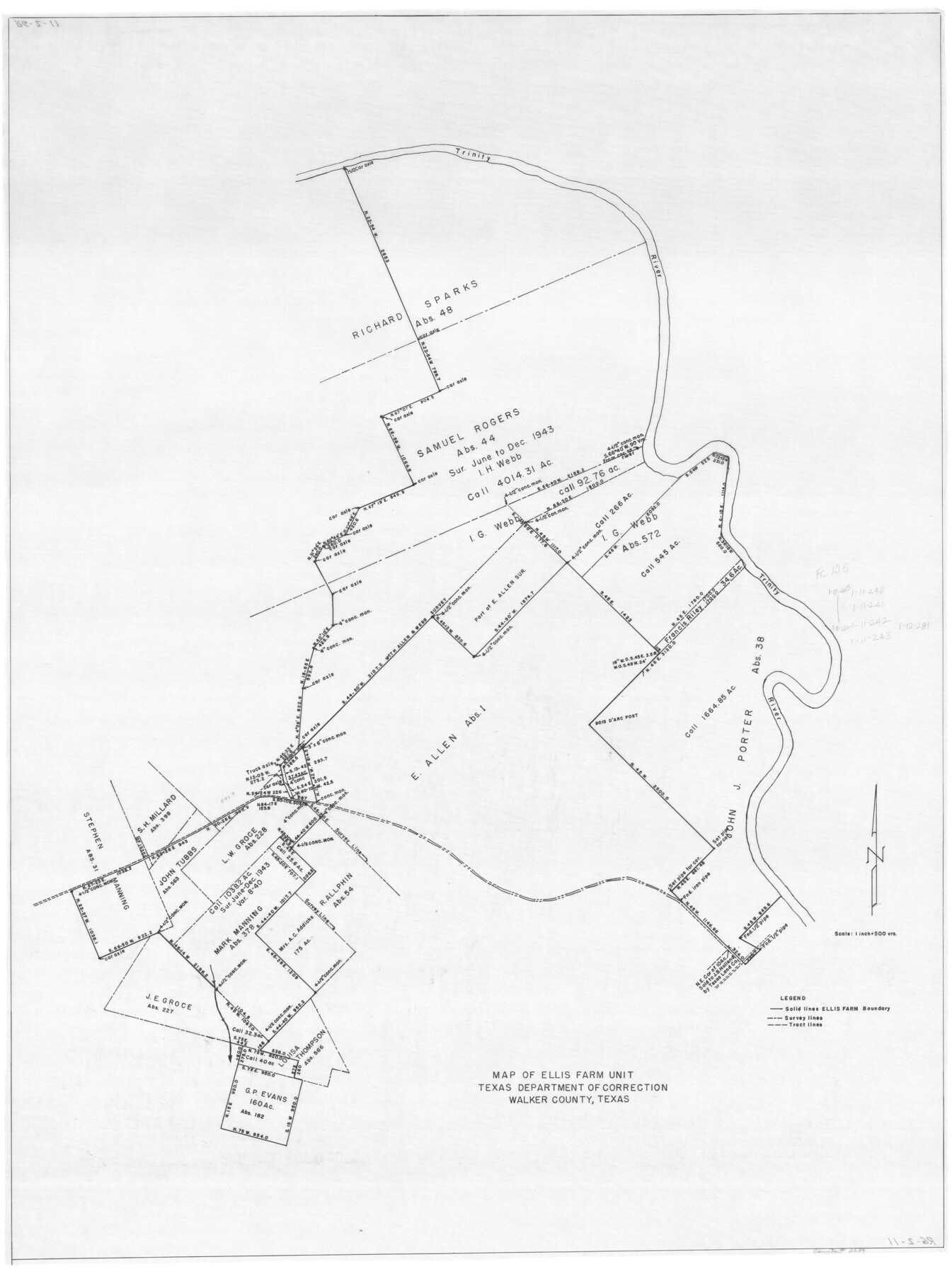
Map of Ellis Farm Unit, Texas Department of Corrections, Walker County, Texas
RG-2-11
-
Map/Doc
2284
-
Collection
General Map Collection
-
People and Organizations
Texas Department of Corrections (Author)
-
Counties
Walker
-
Height x Width
36.3 x 27.1 inches
92.2 x 68.8 cm
Part of: General Map Collection
Bastrop County, From McDade to Austin, Texas, Houston & Texas Central Railroad

Print $20.00
- Digital $50.00
Bastrop County, From McDade to Austin, Texas, Houston & Texas Central Railroad
1939
Size 26.6 x 15.5 inches
Map/Doc 64364
Crosby County Sketch File 27

Print $20.00
- Digital $50.00
Crosby County Sketch File 27
Size 8.8 x 23.0 inches
Map/Doc 11256
Martin County Sketch File 14

Print $46.00
- Digital $50.00
Martin County Sketch File 14
1937
Size 11.2 x 8.8 inches
Map/Doc 30671
Wichita County Rolled Sketch 18

Print $20.00
- Digital $50.00
Wichita County Rolled Sketch 18
1924
Size 30.0 x 40.5 inches
Map/Doc 8253
Hardin County Working Sketch 32

Print $20.00
- Digital $50.00
Hardin County Working Sketch 32
1978
Size 41.7 x 38.0 inches
Map/Doc 63430
Frio County Sketch File 6

Print $32.00
- Digital $50.00
Frio County Sketch File 6
1883
Size 8.7 x 5.3 inches
Map/Doc 23118
Hall County Boundary File 1

Print $26.00
- Digital $50.00
Hall County Boundary File 1
Size 8.8 x 4.0 inches
Map/Doc 54158
Frio County Working Sketch Graphic Index

Print $20.00
- Digital $50.00
Frio County Working Sketch Graphic Index
1944
Size 43.0 x 41.4 inches
Map/Doc 76549
Rusk County Sketch File 28

Print $24.00
Rusk County Sketch File 28
1937
Size 11.4 x 8.7 inches
Map/Doc 35542
Map of the Fort Worth and Denver City Railway, through Wilbarger County Texas, 1882

Print $40.00
- Digital $50.00
Map of the Fort Worth and Denver City Railway, through Wilbarger County Texas, 1882
Size 22.6 x 79.4 inches
Map/Doc 64427
Runnels County Working Sketch 30a

Print $20.00
- Digital $50.00
Runnels County Working Sketch 30a
1959
Size 23.3 x 25.4 inches
Map/Doc 63626
Sabine and Neches Rivers

Print $20.00
- Digital $50.00
Sabine and Neches Rivers
1973
Size 19.7 x 44.6 inches
Map/Doc 69818
You may also like
Flight Mission No. DQO-8K, Frame 40, Galveston County

Print $20.00
- Digital $50.00
Flight Mission No. DQO-8K, Frame 40, Galveston County
1952
Size 18.5 x 22.3 inches
Map/Doc 85147
Coleman County Working Sketch 7

Print $20.00
- Digital $50.00
Coleman County Working Sketch 7
1942
Size 38.0 x 47.8 inches
Map/Doc 68073
Lamar County Sketch File 15

Print $134.00
- Digital $50.00
Lamar County Sketch File 15
1989
Size 14.5 x 9.1 inches
Map/Doc 29310
Oldham County Sketch File 19

Print $20.00
- Digital $50.00
Oldham County Sketch File 19
1904
Size 18.2 x 24.0 inches
Map/Doc 12116
Van Zandt County Sketch File 37

Print $4.00
- Digital $50.00
Van Zandt County Sketch File 37
1861
Size 12.2 x 7.8 inches
Map/Doc 39480
Culberson County Sketch File 23

Print $10.00
- Digital $50.00
Culberson County Sketch File 23
1938
Size 14.2 x 8.6 inches
Map/Doc 20238
J. De Cordova's Map of the State of Texas Compiled from the records of the General Land Office of the State

Print $20.00
J. De Cordova's Map of the State of Texas Compiled from the records of the General Land Office of the State
1851
Size 35.1 x 33.0 inches
Map/Doc 76223
Wharton County Sketch File A4

Print $11.00
- Digital $50.00
Wharton County Sketch File A4
1904
Size 11.0 x 8.4 inches
Map/Doc 39981
Map of San Patricio County

Print $40.00
- Digital $50.00
Map of San Patricio County
1896
Size 29.1 x 48.7 inches
Map/Doc 1336
Lamar County Working Sketch 2

Print $20.00
- Digital $50.00
Lamar County Working Sketch 2
Size 27.9 x 25.6 inches
Map/Doc 70263
Map of the upper surveys in Robertson's Colony Sold by the State of Coahuila and Texas

Print $20.00
- Digital $50.00
Map of the upper surveys in Robertson's Colony Sold by the State of Coahuila and Texas
Size 26.8 x 22.0 inches
Map/Doc 82
Haskell County Boundary File 6

Print $40.00
- Digital $50.00
Haskell County Boundary File 6
Size 7.6 x 33.9 inches
Map/Doc 54582