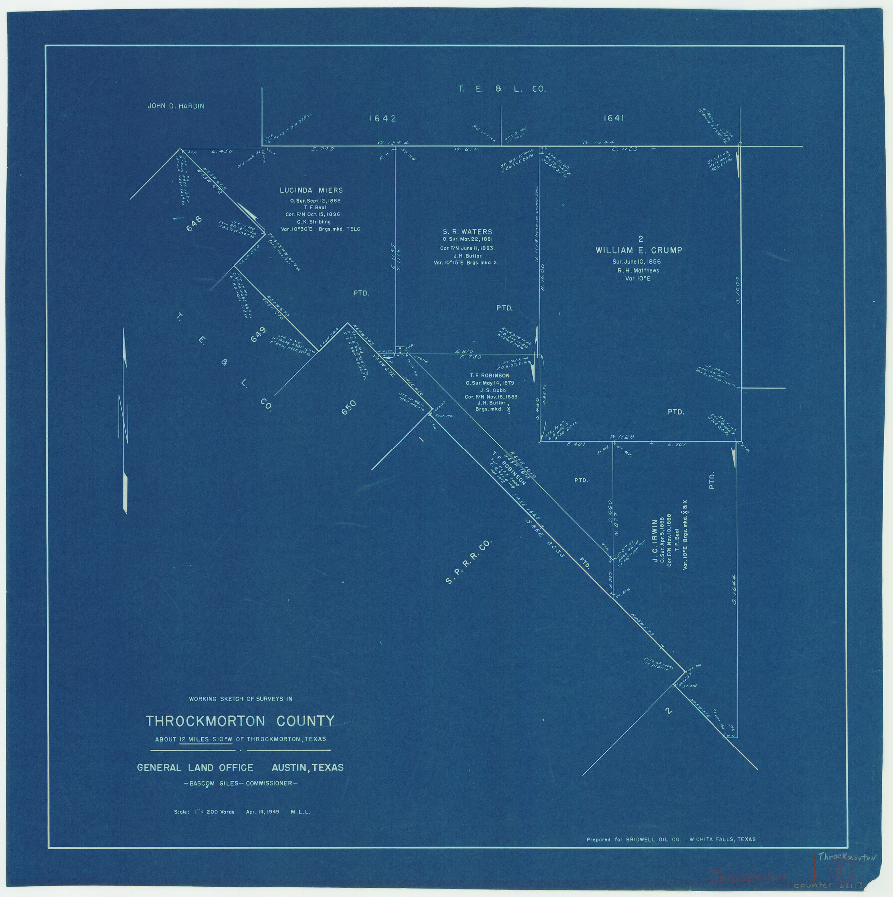
Throckmorton County Working Sketch 4
-
Map/Doc
62113
-
Collection
General Map Collection
-
Object Dates
4/14/1949 (Creation Date)
-
People and Organizations
M. L. Liles (Draftsman)
-
Counties
Throckmorton
-
Subjects
Surveying Working Sketch
-
Height x Width
25.0 x 24.9 inches
63.5 x 63.3 cm
-
Scale
1" = 200 varas
Part of: General Map Collection
Brooks County Working Sketch 20

Print $20.00
- Digital $50.00
Brooks County Working Sketch 20
Size 16.5 x 21.6 inches
Map/Doc 78198

A New Map of Texas, Oregon and California with the Regions adjoining

Print $20.00
- Digital $50.00
A New Map of Texas, Oregon and California with the Regions adjoining
1846
Size 20.4 x 19.3 inches
Map/Doc 89067
Oldham County Working Sketch 10

Print $20.00
- Digital $50.00
Oldham County Working Sketch 10
1983
Size 29.6 x 44.3 inches
Map/Doc 71332
The Great European Alliance against the Mexican Republic

Print $20.00
- Digital $50.00
The Great European Alliance against the Mexican Republic
1861
Size 22.9 x 16.2 inches
Map/Doc 96429
Frio County Sketch File 12

Print $18.00
- Digital $50.00
Frio County Sketch File 12
1938
Size 14.2 x 8.7 inches
Map/Doc 23127
King County Working Sketch Graphic Index

Print $20.00
- Digital $50.00
King County Working Sketch Graphic Index
1947
Size 44.2 x 39.5 inches
Map/Doc 76608
Flight Mission No. DQO-2K, Frame 151, Galveston County

Print $20.00
- Digital $50.00
Flight Mission No. DQO-2K, Frame 151, Galveston County
1952
Size 18.9 x 22.6 inches
Map/Doc 85048
Map of the State of Texas Showing Original Land Districts

Print $20.00
- Digital $50.00
Map of the State of Texas Showing Original Land Districts
1891
Size 43.7 x 43.3 inches
Map/Doc 73598
Starr County Rolled Sketch 30

Print $20.00
- Digital $50.00
Starr County Rolled Sketch 30
1941
Size 14.9 x 21.5 inches
Map/Doc 7813
Map of Panola County

Print $20.00
- Digital $50.00
Map of Panola County
1897
Size 39.5 x 39.1 inches
Map/Doc 66967
Flight Mission No. BRA-8M, Frame 118, Jefferson County

Print $20.00
- Digital $50.00
Flight Mission No. BRA-8M, Frame 118, Jefferson County
1953
Size 18.6 x 22.3 inches
Map/Doc 85614
You may also like
Gaines County Rolled Sketch 24

Print $20.00
- Digital $50.00
Gaines County Rolled Sketch 24
1965
Size 41.8 x 31.3 inches
Map/Doc 9314
Matagorda County Sketch File 39

Print $20.00
- Digital $50.00
Matagorda County Sketch File 39
Size 31.1 x 24.3 inches
Map/Doc 12047
Webb County Rolled Sketch 48

Print $20.00
- Digital $50.00
Webb County Rolled Sketch 48
1943
Size 20.1 x 37.3 inches
Map/Doc 8204
Kinney County Rolled Sketch 16

Print $20.00
- Digital $50.00
Kinney County Rolled Sketch 16
1963
Size 36.4 x 43.8 inches
Map/Doc 9356
Bell County Sketch File 5

Print $4.00
- Digital $50.00
Bell County Sketch File 5
1849
Size 12.9 x 8.5 inches
Map/Doc 14371
Kenedy County Working Sketch 2a

Print $20.00
- Digital $50.00
Kenedy County Working Sketch 2a
1907
Size 22.2 x 20.9 inches
Map/Doc 70003
Eastern Hemisphere

Print $20.00
- Digital $50.00
Eastern Hemisphere
1885
Size 12.2 x 9.0 inches
Map/Doc 93511
Bailey County Sketch File 11

Print $80.00
- Digital $50.00
Bailey County Sketch File 11
Size 21.6 x 20.5 inches
Map/Doc 10886
Burnet County Boundary File 7

Print $36.00
- Digital $50.00
Burnet County Boundary File 7
Size 14.0 x 8.5 inches
Map/Doc 50893
Stonewall County Working Sketch 11

Print $20.00
- Digital $50.00
Stonewall County Working Sketch 11
1950
Size 23.8 x 33.7 inches
Map/Doc 62318
Cherokee County Sketch File 18

Print $4.00
- Digital $50.00
Cherokee County Sketch File 18
1870
Size 10.2 x 8.1 inches
Map/Doc 18159
Flight Mission No. CUG-1P, Frame 50, Kleberg County

Print $20.00
- Digital $50.00
Flight Mission No. CUG-1P, Frame 50, Kleberg County
1956
Size 18.6 x 22.3 inches
Map/Doc 86128