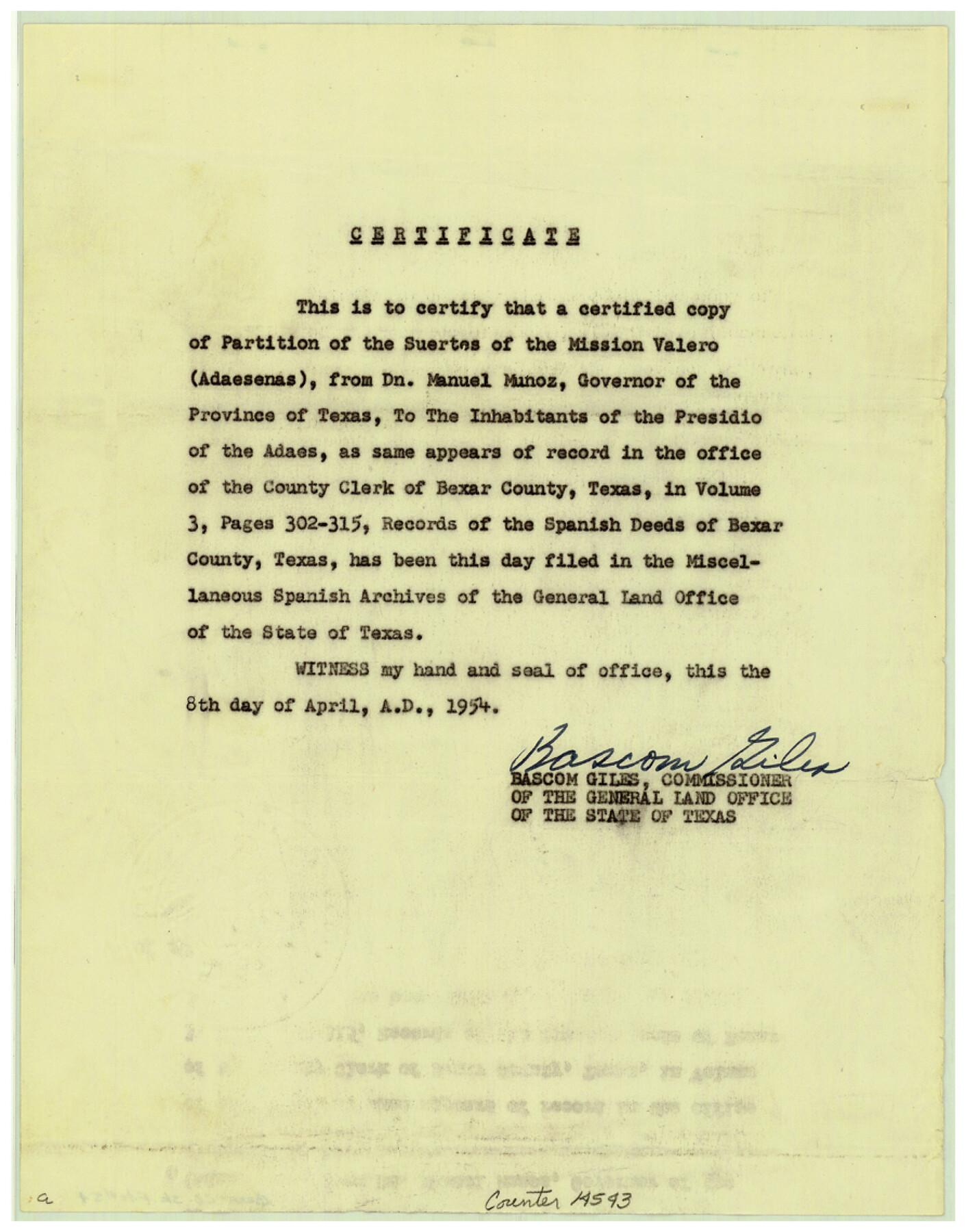
Bexar County Sketch File 54
[Copy of translation of the partition of the suertes of the Mission Valero, 1793, from Don Manuel Munoz, Governor to the inhabitants of the Presidio of the Adaes]
-
Map/Doc
14543
-
Collection
General Map Collection
-
Object Dates
1954/4/8 (File Date)
1793/1/17 (Creation Date)
-
People and Organizations
Manuel Munoz (Author)
-
Counties
Bexar
-
Subjects
Surveying Sketch File
-
Height x Width
11.4 x 8.9 inches
29.0 x 22.6 cm
-
Medium
paper, print
-
Comments
Original filed in the Spanish Collection of the General Land Office, Box GSC 13, Folder 9.
-
Features
San Fernando de Bexar
San Antonio de Bexar
San Antonio Valero
Adaes Presidio
Part of: General Map Collection
Zapata County Sketch File 10

Print $40.00
- Digital $50.00
Zapata County Sketch File 10
1917
Size 51.0 x 32.6 inches
Map/Doc 10440
Coast Chart No. 210 Aransas Pass and Corpus Christi Bay with the coast to latitude 27° 12' Texas

Print $20.00
- Digital $50.00
Coast Chart No. 210 Aransas Pass and Corpus Christi Bay with the coast to latitude 27° 12' Texas
1887
Size 27.5 x 18.3 inches
Map/Doc 72787
Hemphill County Rolled Sketch 11

Print $20.00
- Digital $50.00
Hemphill County Rolled Sketch 11
1941
Size 45.1 x 21.8 inches
Map/Doc 9153
Flight Mission No. DIX-10P, Frame 172, Aransas County

Print $20.00
- Digital $50.00
Flight Mission No. DIX-10P, Frame 172, Aransas County
1956
Size 18.8 x 22.3 inches
Map/Doc 83962
La Salle County Working Sketch 20

Print $20.00
- Digital $50.00
La Salle County Working Sketch 20
1941
Size 23.7 x 29.9 inches
Map/Doc 70321

Baylor County Boundary File 17

Print $20.00
- Digital $50.00
Baylor County Boundary File 17
Size 20.0 x 7.7 inches
Map/Doc 50434
Webb County Sketch File 14a

Print $40.00
- Digital $50.00
Webb County Sketch File 14a
1893
Size 17.4 x 13.7 inches
Map/Doc 39810
Flight Mission No. BRA-7M, Frame 134, Jefferson County

Print $20.00
- Digital $50.00
Flight Mission No. BRA-7M, Frame 134, Jefferson County
1953
Size 18.6 x 22.5 inches
Map/Doc 85528
Flight Mission No. BRA-7M, Frame 151, Jefferson County

Print $20.00
- Digital $50.00
Flight Mission No. BRA-7M, Frame 151, Jefferson County
1953
Size 18.7 x 22.6 inches
Map/Doc 85545
Brazoria County Rolled Sketch 42

Print $20.00
- Digital $50.00
Brazoria County Rolled Sketch 42
1962
Size 35.0 x 44.5 inches
Map/Doc 8461
Colorado County Sketch File 24

Print $20.00
- Digital $50.00
Colorado County Sketch File 24
Size 22.7 x 16.6 inches
Map/Doc 11137
You may also like
Walker County Working Sketch 15

Print $20.00
- Digital $50.00
Walker County Working Sketch 15
1967
Size 26.9 x 24.8 inches
Map/Doc 72295
Upton County Working Sketch Graphic Index, Sheet 2 (Sketches 40 to Most Recent)

Print $40.00
- Digital $50.00
Upton County Working Sketch Graphic Index, Sheet 2 (Sketches 40 to Most Recent)
1969
Size 49.7 x 36.8 inches
Map/Doc 76722
Cottle County

Print $20.00
- Digital $50.00
Cottle County
1971
Size 42.5 x 35.7 inches
Map/Doc 73118
Galveston County NRC Article 33.136 Sketch 32

Print $26.00
- Digital $50.00
Galveston County NRC Article 33.136 Sketch 32
2005
Size 24.5 x 36.8 inches
Map/Doc 83173
Archer County Working Sketch 13

Print $20.00
- Digital $50.00
Archer County Working Sketch 13
1939
Size 12.0 x 18.5 inches
Map/Doc 67154
[South Half - Brown County, Texas]
![97383, [South Half - Brown County, Texas], General Map Collection](https://historictexasmaps.com/wmedia_w700/maps/97383.tif.jpg)
Print $40.00
- Digital $50.00
[South Half - Brown County, Texas]
1919
Size 41.7 x 68.4 inches
Map/Doc 97383
Flight Mission No. DAG-23K, Frame 149, Matagorda County

Print $20.00
- Digital $50.00
Flight Mission No. DAG-23K, Frame 149, Matagorda County
1953
Size 15.9 x 15.9 inches
Map/Doc 86497
Hockley County

Print $20.00
- Digital $50.00
Hockley County
1900
Size 41.5 x 36.7 inches
Map/Doc 16852
Zavala County

Print $20.00
- Digital $50.00
Zavala County
1894
Size 40.5 x 47.9 inches
Map/Doc 63146
Dickens County Sketch File O

Print $8.00
- Digital $50.00
Dickens County Sketch File O
1903
Size 13.3 x 8.7 inches
Map/Doc 20944
The Republic County of Milam. Spring 1842

Print $20.00
The Republic County of Milam. Spring 1842
2020
Size 17.4 x 21.6 inches
Map/Doc 96232
Real County Working Sketch 23

Print $20.00
- Digital $50.00
Real County Working Sketch 23
1946
Size 20.4 x 23.4 inches
Map/Doc 71915