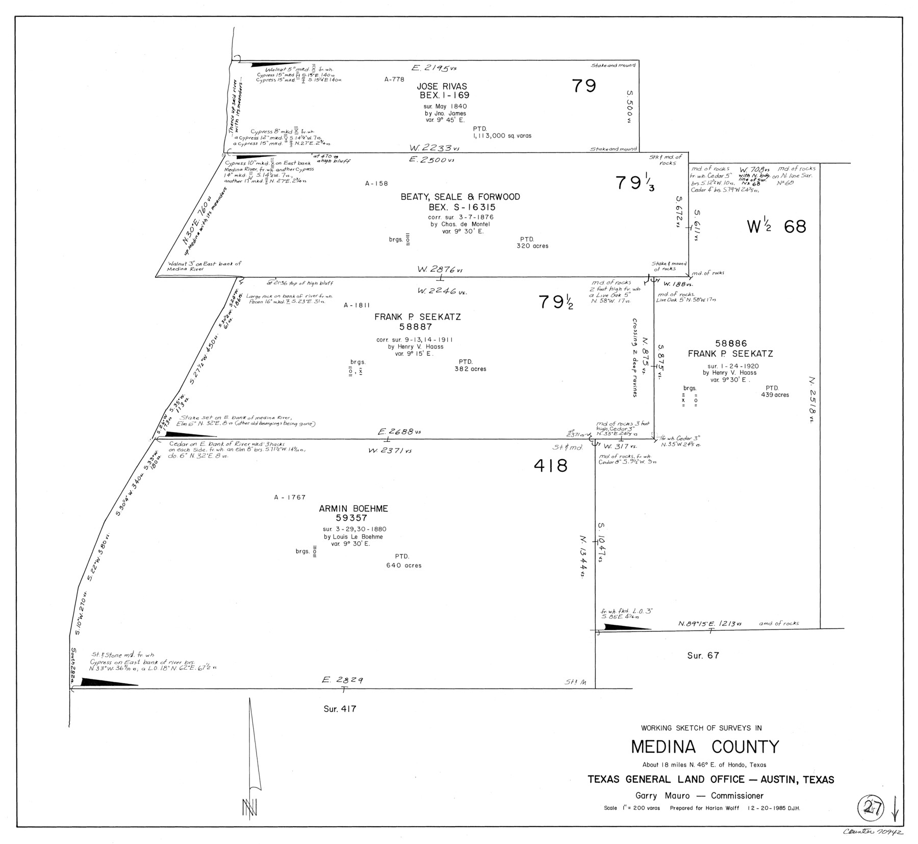
Medina County Working Sketch 27
-
Map/Doc
70942
-
Collection
General Map Collection
-
Object Dates
12/20/1985 (Creation Date)
-
People and Organizations
Douglas Howard (Draftsman)
-
Counties
Medina
-
Subjects
Surveying Working Sketch
-
Height x Width
22.8 x 24.8 inches
57.9 x 63.0 cm
-
Scale
1" = 200 varas
Part of: General Map Collection
Brooks County Rolled Sketch 27

Print $20.00
- Digital $50.00
Brooks County Rolled Sketch 27
1945
Size 44.5 x 42.9 inches
Map/Doc 8540
Burnet County Sketch File 2

Print $4.00
- Digital $50.00
Burnet County Sketch File 2
Size 8.1 x 6.1 inches
Map/Doc 16672
Flight Mission No. BRE-1P, Frame 34, Nueces County

Print $20.00
- Digital $50.00
Flight Mission No. BRE-1P, Frame 34, Nueces County
1956
Size 18.4 x 22.2 inches
Map/Doc 86630
Kinney County Boundary File 1a

Print $73.00
- Digital $50.00
Kinney County Boundary File 1a
Size 8.5 x 43.2 inches
Map/Doc 64946
Stonewall County Working Sketch 22

Print $20.00
- Digital $50.00
Stonewall County Working Sketch 22
1966
Size 44.2 x 32.9 inches
Map/Doc 62329
Aransas County

Print $20.00
- Digital $50.00
Aransas County
1883
Size 19.9 x 17.1 inches
Map/Doc 3236
Upton County Rolled Sketch 45

Print $20.00
- Digital $50.00
Upton County Rolled Sketch 45
Size 25.1 x 43.8 inches
Map/Doc 8081
Culberson County Working Sketch 8

Print $20.00
- Digital $50.00
Culberson County Working Sketch 8
1914
Size 35.4 x 36.0 inches
Map/Doc 68460
McMullen County Working Sketch 34

Print $20.00
- Digital $50.00
McMullen County Working Sketch 34
1959
Size 25.9 x 26.0 inches
Map/Doc 70735
Blanco County Sketch File 21b

Print $40.00
- Digital $50.00
Blanco County Sketch File 21b
1882
Size 16.9 x 17.8 inches
Map/Doc 10930

Atascosa County Sketch File 31

Print $4.00
- Digital $50.00
Atascosa County Sketch File 31
1910
Size 9.4 x 4.3 inches
Map/Doc 13825
You may also like
Shackelford County Sketch File 5

Print $4.00
- Digital $50.00
Shackelford County Sketch File 5
1885
Size 12.3 x 7.6 inches
Map/Doc 36578
Galveston Bay, Texas

Print $20.00
- Digital $50.00
Galveston Bay, Texas
1905
Size 24.8 x 18.5 inches
Map/Doc 65390
Tarrant County Working Sketch 20

Print $20.00
- Digital $50.00
Tarrant County Working Sketch 20
1999
Size 15.4 x 16.8 inches
Map/Doc 62437
[Sketch for Mineral Application 33721 - 33725 Incl. - Padre and Mustang Island]
![2873, [Sketch for Mineral Application 33721 - 33725 Incl. - Padre and Mustang Island], General Map Collection](https://historictexasmaps.com/wmedia_w700/maps/2873.tif.jpg)
Print $20.00
- Digital $50.00
[Sketch for Mineral Application 33721 - 33725 Incl. - Padre and Mustang Island]
1942
Size 26.6 x 22.7 inches
Map/Doc 2873
Fannin County Boundary File 9

Print $14.00
- Digital $50.00
Fannin County Boundary File 9
Size 13.2 x 8.8 inches
Map/Doc 53318
Galveston County Rolled Sketch 42

Print $20.00
- Digital $50.00
Galveston County Rolled Sketch 42
1982
Size 42.9 x 40.6 inches
Map/Doc 9021
General Highway Map, Starr County, Texas

Print $20.00
General Highway Map, Starr County, Texas
1940
Size 24.7 x 18.5 inches
Map/Doc 79245
Flight Mission No. CGI-3N, Frame 145, Cameron County

Print $20.00
- Digital $50.00
Flight Mission No. CGI-3N, Frame 145, Cameron County
1954
Size 18.6 x 22.3 inches
Map/Doc 84618
Montgomery County Rolled Sketch 41

Print $20.00
- Digital $50.00
Montgomery County Rolled Sketch 41
1975
Size 35.2 x 26.8 inches
Map/Doc 6814
Llano County Sketch File 11

Print $10.00
- Digital $50.00
Llano County Sketch File 11
1885
Size 9.5 x 8.5 inches
Map/Doc 30375
[Field notes, sketch and legislation regarding the National Road from Dallas at the mouth of the Elm Fork of the Trinity to the mouth of Kiamechi on Red River]
![65469, [Field notes, sketch and legislation regarding the National Road from Dallas at the mouth of the Elm Fork of the Trinity to the mouth of Kiamechi on Red River], General Map Collection](https://historictexasmaps.com/wmedia_w700/pdf_converted_jpg/qi_pdf_thumbnail_19857.jpg)
Print $84.00
- Digital $50.00
[Field notes, sketch and legislation regarding the National Road from Dallas at the mouth of the Elm Fork of the Trinity to the mouth of Kiamechi on Red River]
1844
Size 6.8 x 11.2 inches
Map/Doc 65469
Tarrant County Working Sketch 11

Print $20.00
- Digital $50.00
Tarrant County Working Sketch 11
1986
Size 42.5 x 32.6 inches
Map/Doc 62428