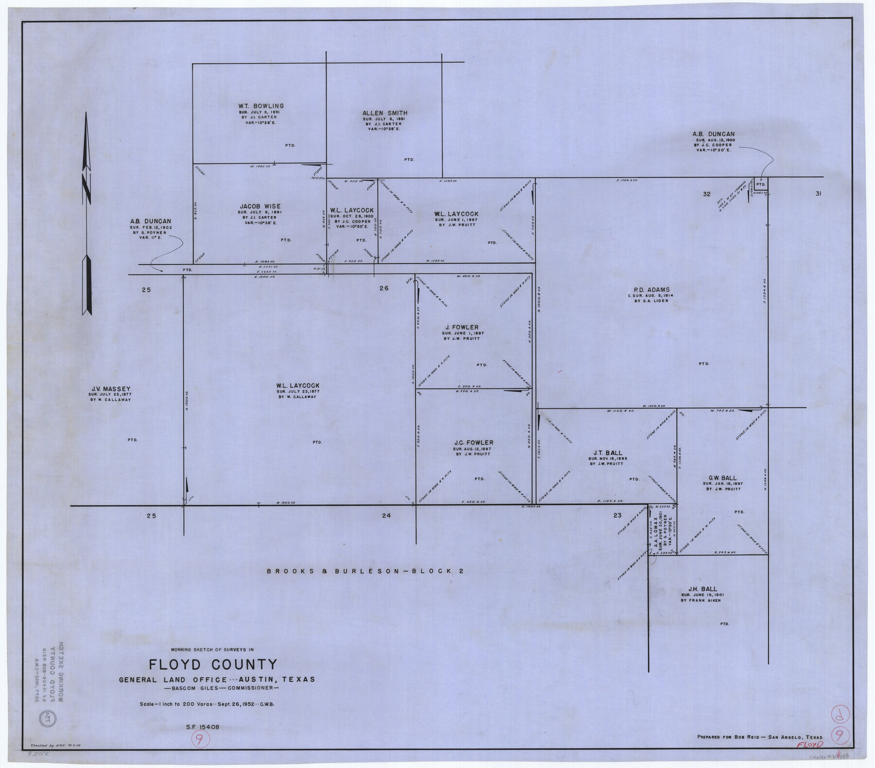
Floyd County Working Sketch 9
-
Map/Doc
69188
-
Collection
General Map Collection
-
Object Dates
9/26/1952 (Creation Date)
-
Counties
Floyd
-
Subjects
Surveying Working Sketch
-
Height x Width
31.5 x 35.9 inches
80.0 x 91.2 cm
-
Scale
1" = 200 varas
Part of: General Map Collection
Galveston County NRC Article 33.136 Location Key Sheet

Print $20.00
- Digital $50.00
Galveston County NRC Article 33.136 Location Key Sheet
1995
Size 27.0 x 22.0 inches
Map/Doc 83001
Somervell County Working Sketch 3

Print $20.00
- Digital $50.00
Somervell County Working Sketch 3
1968
Size 23.0 x 30.4 inches
Map/Doc 63907
Lamar County State Real Property Sketch 1

Print $40.00
- Digital $50.00
Lamar County State Real Property Sketch 1
2013
Size 48.0 x 36.0 inches
Map/Doc 93662
Caldwell County Sketch File 3a

Print $4.00
- Digital $50.00
Caldwell County Sketch File 3a
1870
Size 10.1 x 8.1 inches
Map/Doc 35829
Collingsworth County

Print $20.00
- Digital $50.00
Collingsworth County
1892
Size 26.5 x 20.8 inches
Map/Doc 66759

Calcasieu Pass to Sabine Pass

Print $20.00
- Digital $50.00
Calcasieu Pass to Sabine Pass
1992
Size 44.5 x 35.8 inches
Map/Doc 69815
Flight Mission No. CUG-1P, Frame 69, Kleberg County

Print $20.00
- Digital $50.00
Flight Mission No. CUG-1P, Frame 69, Kleberg County
1956
Size 18.6 x 22.3 inches
Map/Doc 86134
Controlled Mosaic by Jack Amman Photogrammetric Engineers, Inc - Sheet 3

Print $20.00
- Digital $50.00
Controlled Mosaic by Jack Amman Photogrammetric Engineers, Inc - Sheet 3
1954
Size 20.0 x 24.0 inches
Map/Doc 83447
Kleberg County Rolled Sketch 10-32

Print $20.00
- Digital $50.00
Kleberg County Rolled Sketch 10-32
1952
Size 36.2 x 34.5 inches
Map/Doc 9369

Flight Mission No. BRA-7M, Frame 135, Jefferson County

Print $20.00
- Digital $50.00
Flight Mission No. BRA-7M, Frame 135, Jefferson County
1953
Size 18.6 x 22.4 inches
Map/Doc 85529
You may also like
Current Miscellaneous File 117

Print $8.00
- Digital $50.00
Current Miscellaneous File 117
2001
Size 11.2 x 8.8 inches
Map/Doc 74823
Map of the Northeast Part of the Pitchfork Ranch

Print $20.00
- Digital $50.00
Map of the Northeast Part of the Pitchfork Ranch
1916
Size 23.4 x 23.4 inches
Map/Doc 90980
Harris County Working Sketch 51

Print $20.00
- Digital $50.00
Harris County Working Sketch 51
1947
Size 39.6 x 36.6 inches
Map/Doc 65943
Flight Mission No. CGI-3N, Frame 182, Cameron County

Print $20.00
- Digital $50.00
Flight Mission No. CGI-3N, Frame 182, Cameron County
1954
Size 18.7 x 22.3 inches
Map/Doc 84646
Topographical Map of the Rio Grande, Sheet No. 23

Print $20.00
- Digital $50.00
Topographical Map of the Rio Grande, Sheet No. 23
1912
Map/Doc 89547
Bandera County Working Sketch 43

Print $20.00
- Digital $50.00
Bandera County Working Sketch 43
1978
Size 27.7 x 31.6 inches
Map/Doc 67639
Map of Southeastern Part of Young Territory

Print $40.00
- Digital $50.00
Map of Southeastern Part of Young Territory
1874
Size 54.7 x 30.1 inches
Map/Doc 1989
Hunt County Sketch File 11

Print $4.00
- Digital $50.00
Hunt County Sketch File 11
1860
Size 12.1 x 7.6 inches
Map/Doc 27102
Flight Mission No. BRE-1P, Frame 72, Nueces County

Print $20.00
- Digital $50.00
Flight Mission No. BRE-1P, Frame 72, Nueces County
1956
Size 18.4 x 22.3 inches
Map/Doc 86654
Agua Fria Quadrangle

Print $20.00
- Digital $50.00
Agua Fria Quadrangle
1917
Size 17.2 x 21.1 inches
Map/Doc 90136
Tom Green County Rolled Sketch 11

Print $20.00
- Digital $50.00
Tom Green County Rolled Sketch 11
Size 33.0 x 27.9 inches
Map/Doc 7998
Milam County Working Sketch 6

Print $20.00
- Digital $50.00
Milam County Working Sketch 6
1963
Size 29.1 x 23.9 inches
Map/Doc 71021