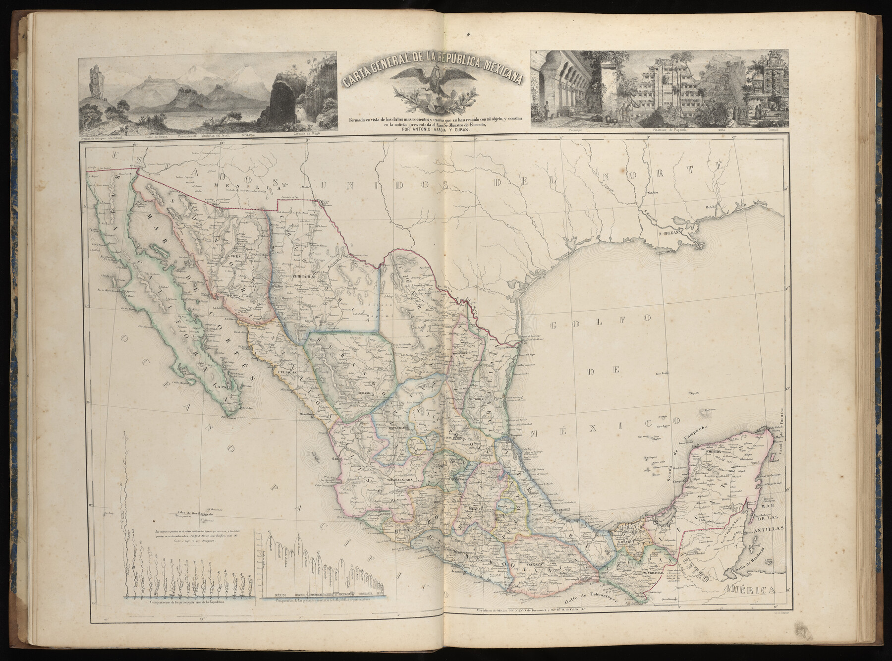
Carta General de la Republica Mexicana
-
Map/Doc
96983
-
Collection
General Map Collection
-
Object Dates
1858 (Publication Date)
-
People and Organizations
Antonio García y Cubas (Cartographer)
-
Subjects
Atlas Mexico
-
Height x Width
23.1 x 31.1 inches
58.7 x 79.0 cm
-
Medium
paper, etching/engraving/lithograph
-
Comments
Map 2 of 32 from "Atlas Geografico, Estadistico e Historico de la Republica Mexicana" (95689)
Related maps
Atlas Geográfico, Estadístico é Histórico de la República Mexicana

Atlas Geográfico, Estadístico é Histórico de la República Mexicana
Map/Doc 95689
Part of: General Map Collection
Baylor County Rolled Sketch 5

Print $20.00
- Digital $50.00
Baylor County Rolled Sketch 5
1874
Size 43.2 x 39.7 inches
Map/Doc 8444
Brewster County Working Sketch 72

Print $20.00
- Digital $50.00
Brewster County Working Sketch 72
1965
Size 20.7 x 24.6 inches
Map/Doc 67672
Van Zandt County Working Sketch 7

Print $20.00
- Digital $50.00
Van Zandt County Working Sketch 7
1953
Size 17.7 x 18.1 inches
Map/Doc 72257
Pecos County Rolled Sketch 148

Print $20.00
- Digital $50.00
Pecos County Rolled Sketch 148
Size 30.3 x 42.6 inches
Map/Doc 7279
Borden County Working Sketch 4

Print $20.00
- Digital $50.00
Borden County Working Sketch 4
1944
Size 21.7 x 23.7 inches
Map/Doc 67464
Nueces River, North Extension Clarkwood Sheet

Print $2.00
- Digital $50.00
Nueces River, North Extension Clarkwood Sheet
1942
Size 14.5 x 17.7 inches
Map/Doc 65100
Wood County Boundary File 1

Print $4.00
- Digital $50.00
Wood County Boundary File 1
Size 12.6 x 8.1 inches
Map/Doc 60154
Aransas County Sketch File 25

Print $20.00
- Digital $50.00
Aransas County Sketch File 25
Size 17.0 x 17.5 inches
Map/Doc 13218
Bandera County Working Sketch 34

Print $20.00
- Digital $50.00
Bandera County Working Sketch 34
1963
Size 36.5 x 29.2 inches
Map/Doc 67630

Cameron County Sketch File 13

Print $50.00
- Digital $50.00
Cameron County Sketch File 13
Size 11.0 x 8.5 inches
Map/Doc 17298
Brown County Working Sketch 6

Print $20.00
- Digital $50.00
Brown County Working Sketch 6
1948
Size 12.9 x 19.3 inches
Map/Doc 67771
You may also like
Harris County Sketch File C

Print $4.00
- Digital $50.00
Harris County Sketch File C
1866
Size 5.9 x 9.8 inches
Map/Doc 25311
Flight Mission No. DIX-8P, Frame 72, Aransas County

Print $20.00
- Digital $50.00
Flight Mission No. DIX-8P, Frame 72, Aransas County
1956
Size 18.7 x 22.4 inches
Map/Doc 83903
Map of Falls County, Texas

Print $20.00
- Digital $50.00
Map of Falls County, Texas
1879
Size 19.4 x 23.0 inches
Map/Doc 724
Flight Mission No. DQN-7K, Frame 88, Calhoun County

Print $20.00
- Digital $50.00
Flight Mission No. DQN-7K, Frame 88, Calhoun County
1953
Size 18.5 x 22.1 inches
Map/Doc 84479
[F. W. & D. C. Ry. Co. Alignment and Right of Way Map, Clay County]
![64731, [F. W. & D. C. Ry. Co. Alignment and Right of Way Map, Clay County], General Map Collection](https://historictexasmaps.com/wmedia_w700/maps/64731-1.tif.jpg)
Print $20.00
- Digital $50.00
[F. W. & D. C. Ry. Co. Alignment and Right of Way Map, Clay County]
1927
Size 18.7 x 11.8 inches
Map/Doc 64731
Flight Mission No. BRE-2P, Frame 82, Nueces County

Print $20.00
- Digital $50.00
Flight Mission No. BRE-2P, Frame 82, Nueces County
1956
Size 18.5 x 22.6 inches
Map/Doc 86777
Flight Mission No. DQO-8K, Frame 88, Galveston County

Print $20.00
- Digital $50.00
Flight Mission No. DQO-8K, Frame 88, Galveston County
1952
Size 18.7 x 22.4 inches
Map/Doc 85190
Wilson County Working Sketch 9

Print $20.00
- Digital $50.00
Wilson County Working Sketch 9
1979
Size 31.6 x 33.0 inches
Map/Doc 72589
Webb County Sketch File 23

Print $20.00
- Digital $50.00
Webb County Sketch File 23
1923
Size 25.4 x 16.3 inches
Map/Doc 12638
The University of Texas at Austin

The University of Texas at Austin
Size 16.1 x 17.1 inches
Map/Doc 94387
Houston County Working Sketch 15

Print $20.00
- Digital $50.00
Houston County Working Sketch 15
1960
Size 26.3 x 20.0 inches
Map/Doc 66245
Subdivision Map of Floyd County School Land Situated in Bailey County, Texas

Print $20.00
- Digital $50.00
Subdivision Map of Floyd County School Land Situated in Bailey County, Texas
Size 20.5 x 25.1 inches
Map/Doc 92530