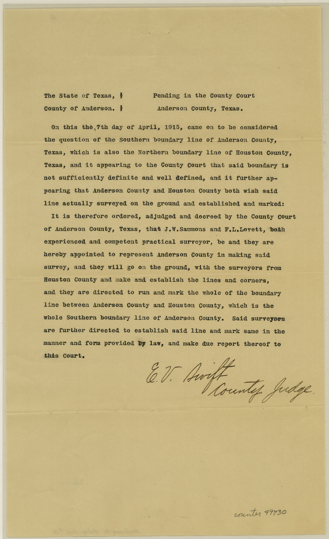
Anderson County Boundary File 2
Certified copy of order appointing surveyors to run County Line
-
Map/Doc
49730
-
Collection
General Map Collection
-
Counties
Anderson
-
Subjects
County Boundaries
-
Height x Width
14.3 x 8.7 inches
36.3 x 22.1 cm
Part of: General Map Collection
Presidio County Working Sketch 105

Print $20.00
- Digital $50.00
Presidio County Working Sketch 105
1980
Size 27.5 x 27.5 inches
Map/Doc 71782
Jeff Davis County Working Sketch 20

Print $40.00
- Digital $50.00
Jeff Davis County Working Sketch 20
1957
Size 63.0 x 32.8 inches
Map/Doc 66515
Flight Mission No. CLL-3N, Frame 40, Willacy County

Print $20.00
- Digital $50.00
Flight Mission No. CLL-3N, Frame 40, Willacy County
1954
Size 18.3 x 22.0 inches
Map/Doc 87098
Map of Texas Compiled from surveys on record in the General Land Office of the Republic to the year 1839

Print $20.00
- Digital $50.00
Map of Texas Compiled from surveys on record in the General Land Office of the Republic to the year 1839
1891
Size 36.6 x 25.7 inches
Map/Doc 1891
Bastrop County Working Sketch 2

Print $20.00
- Digital $50.00
Bastrop County Working Sketch 2
1913
Size 14.0 x 13.6 inches
Map/Doc 67302
Harris County Working Sketch 112

Print $20.00
- Digital $50.00
Harris County Working Sketch 112
1982
Size 31.0 x 38.1 inches
Map/Doc 66004

Sherman County Sketch File 1

Print $20.00
- Digital $50.00
Sherman County Sketch File 1
1923
Size 25.3 x 25.4 inches
Map/Doc 12322
Concho County Sketch File 23

Print $6.00
- Digital $50.00
Concho County Sketch File 23
Size 11.0 x 7.3 inches
Map/Doc 19146
Loving County Working Sketch 5

Print $20.00
- Digital $50.00
Loving County Working Sketch 5
1946
Size 29.7 x 39.0 inches
Map/Doc 70637

Duval County Sketch File 35c

Print $6.00
- Digital $50.00
Duval County Sketch File 35c
1935
Size 14.5 x 8.8 inches
Map/Doc 21377
You may also like
Sterling County Rolled Sketch X

Print $117.00
- Digital $50.00
Sterling County Rolled Sketch X
Size 15.3 x 9.6 inches
Map/Doc 49097
Crockett County Rolled Sketch 48

Print $20.00
- Digital $50.00
Crockett County Rolled Sketch 48
1939
Size 30.0 x 40.3 inches
Map/Doc 8712
[Map of Panhandle Counties]
![91170, [Map of Panhandle Counties], Twichell Survey Records](https://historictexasmaps.com/wmedia_w700/maps/91170-1.tif.jpg)
Print $20.00
- Digital $50.00
[Map of Panhandle Counties]
Size 27.4 x 22.9 inches
Map/Doc 91170
Bell County Sketch File 19

Print $4.00
- Digital $50.00
Bell County Sketch File 19
Size 7.6 x 7.7 inches
Map/Doc 14402
Edwards County Working Sketch 109

Print $40.00
- Digital $50.00
Edwards County Working Sketch 109
1972
Size 51.8 x 37.6 inches
Map/Doc 68985
Carson County Working Sketch 5

Print $20.00
- Digital $50.00
Carson County Working Sketch 5
1979
Size 42.2 x 14.5 inches
Map/Doc 67876
Runnels County Working Sketch 30b
Print $20.00
- Digital $50.00
Runnels County Working Sketch 30b
Size 23.2 x 25.3 inches
Map/Doc 63627
Map of Ramsey State Farm

Print $20.00
- Digital $50.00
Map of Ramsey State Farm
1934
Size 30.3 x 38.0 inches
Map/Doc 94284
Karnes County Sketch File 6

Print $4.00
- Digital $50.00
Karnes County Sketch File 6
1858
Size 7.7 x 8.1 inches
Map/Doc 28557
Flight Mission No. BQR-4K, Frame 59, Brazoria County

Print $20.00
- Digital $50.00
Flight Mission No. BQR-4K, Frame 59, Brazoria County
1952
Size 18.7 x 22.4 inches
Map/Doc 83992

![94183, Texas [Recto], General Map Collection](https://historictexasmaps.com/wmedia_w700/maps/94183.tif.jpg)