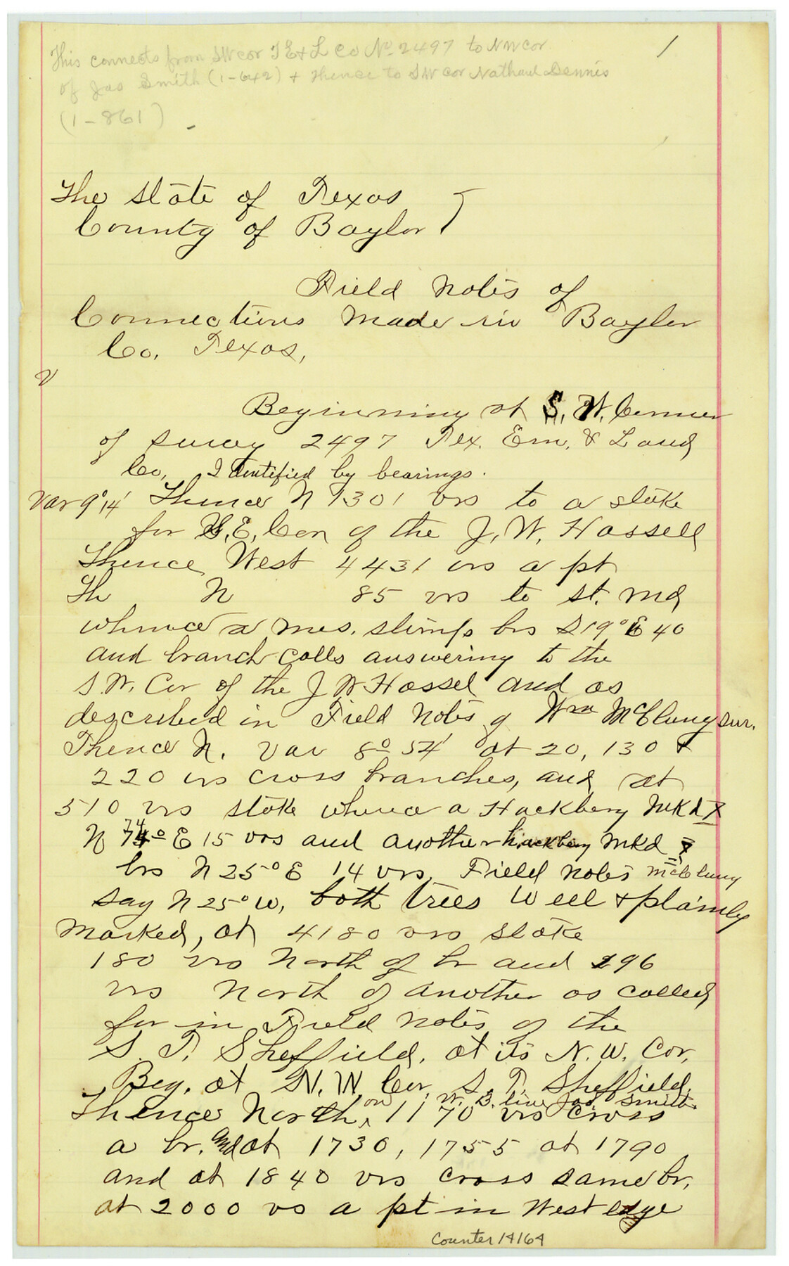
Baylor County Sketch File 12f
[Connecting lines for surveys north of Brazos River]
-
Map/Doc
14164
-
Collection
General Map Collection
-
Object Dates
1900 (Creation Date)
1900/11/22 (File Date)
1900/11/9 (Survey Date)
1900/11/10 (Survey Date)
-
People and Organizations
A.D. Kerr (Surveyor/Engineer)
H.M. Jamison (Chainman/Field Personnel)
Wm. Gray (Chainman/Field Personnel)
H.H. Porter (Chainman/Field Personnel)
Chas. T. Porter (Chainman/Field Personnel)
-
Counties
Baylor
-
Subjects
Surveying Sketch File
-
Height x Width
14.4 x 9.0 inches
36.6 x 22.9 cm
-
Medium
paper, manuscript
-
Features
Deep Creek
Brazos River
Turkey Creek
Part of: General Map Collection
Map of Gaines County

Print $40.00
- Digital $50.00
Map of Gaines County
1900
Size 59.4 x 37.4 inches
Map/Doc 16832
Gaines County Working Sketch 17

Print $20.00
- Digital $50.00
Gaines County Working Sketch 17
1964
Size 47.6 x 34.5 inches
Map/Doc 69317
Presidio County Rolled Sketch 34

Print $20.00
- Digital $50.00
Presidio County Rolled Sketch 34
1890
Size 46.1 x 32.9 inches
Map/Doc 9773
Flight Mission No. CRC-3R, Frame 52, Chambers County

Print $20.00
- Digital $50.00
Flight Mission No. CRC-3R, Frame 52, Chambers County
1956
Size 18.7 x 22.3 inches
Map/Doc 89041
Zapata County Rolled Sketch 25

Print $20.00
- Digital $50.00
Zapata County Rolled Sketch 25
Size 45.7 x 37.9 inches
Map/Doc 10172
Harris County Historic Topographic 20

Print $20.00
- Digital $50.00
Harris County Historic Topographic 20
1915
Size 29.3 x 22.6 inches
Map/Doc 65831
Map of Refugio District

Print $20.00
- Digital $50.00
Map of Refugio District
1850
Size 22.6 x 25.1 inches
Map/Doc 1959
Hockley County Rolled Sketch 4

Print $40.00
- Digital $50.00
Hockley County Rolled Sketch 4
Size 40.5 x 54.7 inches
Map/Doc 9174
Culberson County Working Sketch 5

Print $20.00
- Digital $50.00
Culberson County Working Sketch 5
1906
Size 22.2 x 17.2 inches
Map/Doc 68457
Culberson County Working Sketch 30

Print $20.00
- Digital $50.00
Culberson County Working Sketch 30
1958
Size 29.3 x 30.2 inches
Map/Doc 68483

Newton County Working Sketch 40

Print $20.00
- Digital $50.00
Newton County Working Sketch 40
1970
Size 43.6 x 39.7 inches
Map/Doc 71286
You may also like
Trinity County Working Sketch 20

Print $20.00
- Digital $50.00
Trinity County Working Sketch 20
Size 25.9 x 29.7 inches
Map/Doc 69469
Flight Mission No. DAG-21K, Frame 37, Matagorda County

Print $20.00
- Digital $50.00
Flight Mission No. DAG-21K, Frame 37, Matagorda County
1952
Size 18.5 x 22.4 inches
Map/Doc 86404
Angelina County Working Sketch 26

Print $40.00
- Digital $50.00
Angelina County Working Sketch 26
1954
Size 50.0 x 67.9 inches
Map/Doc 67108
Harris County Rolled Sketch P4

Print $20.00
- Digital $50.00
Harris County Rolled Sketch P4
1920
Size 12.1 x 34.6 inches
Map/Doc 6143
Map of Kaufman County, Texas

Print $20.00
- Digital $50.00
Map of Kaufman County, Texas
Size 29.7 x 38.7 inches
Map/Doc 91029
Haskell County Working Sketch 3

Print $20.00
- Digital $50.00
Haskell County Working Sketch 3
1920
Size 41.4 x 21.9 inches
Map/Doc 66061
Map of Liberty County Texas

Print $20.00
- Digital $50.00
Map of Liberty County Texas
1895
Size 25.1 x 26.6 inches
Map/Doc 3812
Flight Mission No. BRA-9M, Frame 76, Jefferson County

Print $20.00
- Digital $50.00
Flight Mission No. BRA-9M, Frame 76, Jefferson County
1953
Size 18.5 x 22.5 inches
Map/Doc 85659
Flight Mission No. CUG-3P, Frame 94, Kleberg County

Print $20.00
- Digital $50.00
Flight Mission No. CUG-3P, Frame 94, Kleberg County
1956
Size 18.4 x 22.2 inches
Map/Doc 86264
Flight Mission No. CRK-5P, Frame 162, Refugio County

Print $20.00
- Digital $50.00
Flight Mission No. CRK-5P, Frame 162, Refugio County
1956
Size 18.5 x 22.3 inches
Map/Doc 86943
Duval County Working Sketch 28

Print $20.00
- Digital $50.00
Duval County Working Sketch 28
1948
Size 29.7 x 37.4 inches
Map/Doc 68752
Atascosa County Boundary File 5

Print $32.00
- Digital $50.00
Atascosa County Boundary File 5
Size 8.8 x 6.3 inches
Map/Doc 50198