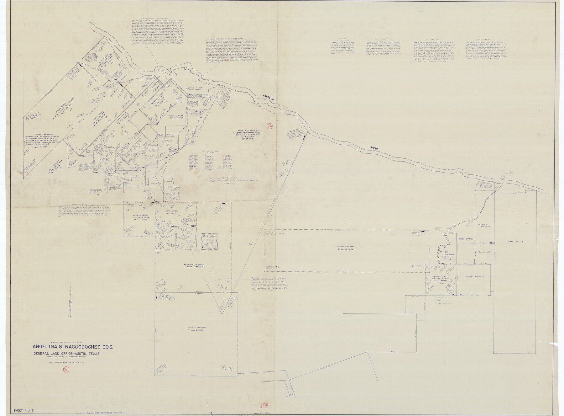
Angelina County Working Sketch 26
-
Map/Doc
67108
-
Collection
General Map Collection
-
Object Dates
3/30/1954 (Creation Date)
-
People and Organizations
Bascom Giles (GLO Commissioner)
Roy Buckholts (Draftsman)
-
Counties
Angelina Nacogdoches
-
Subjects
Surveying Working Sketch
-
Height x Width
50.0 x 67.9 inches
127.0 x 172.5 cm
-
Scale
1" = 500 varas
-
Comments
Surveys located about eight miles North 30 degrees West from Lufkin, Texas.
Part of: General Map Collection
[Surveys in the Travis District along the Colorado River]
![120, [Surveys in the Travis District along the Colorado River], General Map Collection](https://historictexasmaps.com/wmedia_w700/maps/120-2.tif.jpg)
Print $3.00
- Digital $50.00
[Surveys in the Travis District along the Colorado River]
1841
Size 7.0 x 16.5 inches
Map/Doc 120
Goliad County Sketch File 37

Print $4.00
- Digital $50.00
Goliad County Sketch File 37
1850
Size 10.2 x 8.3 inches
Map/Doc 24336
San Patricio County Working Sketch 25

Print $20.00
- Digital $50.00
San Patricio County Working Sketch 25
1951
Size 20.3 x 25.4 inches
Map/Doc 63787
Archer County Sketch File 25

Print $40.00
- Digital $50.00
Archer County Sketch File 25
Size 22.3 x 46.6 inches
Map/Doc 10348
Texas Official Highway Travel Map

Digital $50.00
Texas Official Highway Travel Map
1975
Size 27.2 x 36.2 inches
Map/Doc 94312
Kaufman County Boundary File 3

Print $14.00
- Digital $50.00
Kaufman County Boundary File 3
Size 12.7 x 8.2 inches
Map/Doc 55922
Flight Mission No. BRE-1P, Frame 52, Nueces County

Print $20.00
- Digital $50.00
Flight Mission No. BRE-1P, Frame 52, Nueces County
1956
Size 18.4 x 22.0 inches
Map/Doc 86641
Stephens County Sketch File 10c

Print $6.00
- Digital $50.00
Stephens County Sketch File 10c
Size 7.8 x 11.5 inches
Map/Doc 37052
Texas Panhandle East Boundary Line

Print $20.00
- Digital $50.00
Texas Panhandle East Boundary Line
1898
Size 11.6 x 35.5 inches
Map/Doc 1741
Pecos County Rolled Sketch 32A

Print $7.00
- Digital $50.00
Pecos County Rolled Sketch 32A
1890
Size 10.5 x 15.2 inches
Map/Doc 48096
Crockett County Working Sketch 20

Print $20.00
- Digital $50.00
Crockett County Working Sketch 20
1920
Size 43.7 x 27.6 inches
Map/Doc 68353
San Jacinto County Boundary File 1

Print $6.00
- Digital $50.00
San Jacinto County Boundary File 1
Size 9.6 x 8.4 inches
Map/Doc 58548
You may also like
Map of Donley County

Print $20.00
- Digital $50.00
Map of Donley County
1894
Size 44.6 x 35.8 inches
Map/Doc 16823
El Paso County Rolled Sketch 52

Print $20.00
- Digital $50.00
El Paso County Rolled Sketch 52
1929
Size 18.5 x 24.3 inches
Map/Doc 5849
Presidio County Rolled Sketch 102

Print $20.00
- Digital $50.00
Presidio County Rolled Sketch 102
1957
Size 22.8 x 17.4 inches
Map/Doc 7384

Flight Mission No. CUG-3P, Frame 165, Kleberg County

Print $20.00
- Digital $50.00
Flight Mission No. CUG-3P, Frame 165, Kleberg County
1956
Size 18.5 x 22.2 inches
Map/Doc 86285
Hall County Working Sketch 9

Print $20.00
- Digital $50.00
Hall County Working Sketch 9
1972
Size 36.9 x 39.4 inches
Map/Doc 63337
Flight Mission No. DQO-6K, Frame 34, Galveston County

Print $20.00
- Digital $50.00
Flight Mission No. DQO-6K, Frame 34, Galveston County
1952
Size 18.7 x 22.4 inches
Map/Doc 85100
Kimble County

Print $40.00
- Digital $50.00
Kimble County
1890
Size 39.2 x 57.5 inches
Map/Doc 78435
Presidio County Working Sketch 47

Print $20.00
- Digital $50.00
Presidio County Working Sketch 47
1950
Size 30.2 x 39.5 inches
Map/Doc 71724
Eastland County Working Sketch 29

Print $20.00
- Digital $50.00
Eastland County Working Sketch 29
1952
Size 21.1 x 22.3 inches
Map/Doc 68810
[Sections 59-70, I. & G. N. Block 1 and Runnels County School Land League 3]
![91680, [Sections 59-70, I. & G. N. Block 1 and Runnels County School Land League 3], Twichell Survey Records](https://historictexasmaps.com/wmedia_w700/maps/91680-1.tif.jpg)
Print $20.00
- Digital $50.00
[Sections 59-70, I. & G. N. Block 1 and Runnels County School Land League 3]
Size 22.7 x 20.4 inches
Map/Doc 91680
Right of Way and Track Map, International & Gt. Northern Ry. Operated by the International & Gt. Northern Ry. Co., Gulf Division

Print $40.00
- Digital $50.00
Right of Way and Track Map, International & Gt. Northern Ry. Operated by the International & Gt. Northern Ry. Co., Gulf Division
1917
Size 24.9 x 56.5 inches
Map/Doc 64247