Bailey County Sketch File 4
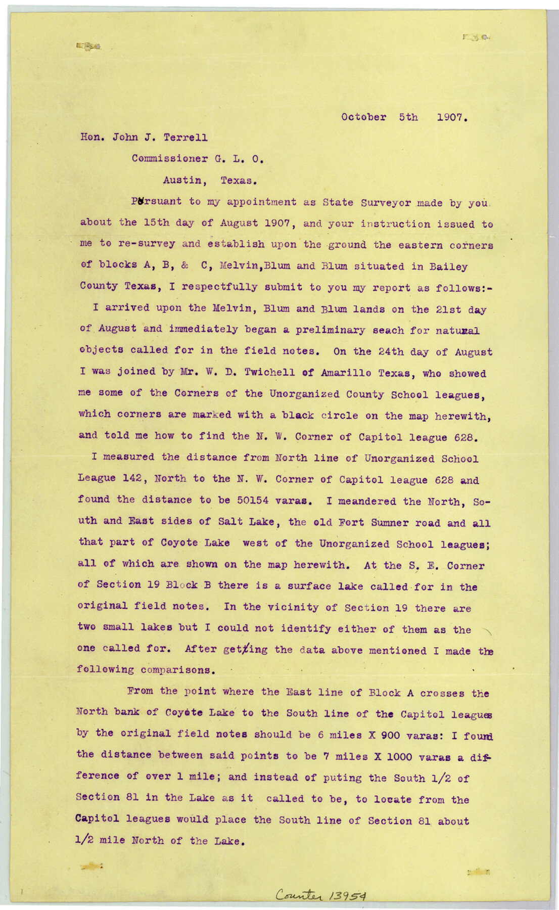
[R.S. Hunnicutt's report establishing the eastern corners of Melvin, Blum & Blum Blocks A, B, and C]
-
Map/Doc
13954
-
Collection
General Map Collection
-
Object Dates
1907/10/4 (Creation Date)
-
People and Organizations
R.S. Hunnicutt (Surveyor/Engineer)
-
Counties
Bailey
-
Subjects
Surveying Sketch File
-
Height x Width
14.2 x 8.7 inches
36.1 x 22.1 cm
-
Medium
paper, print
-
Comments
See Bailey County Sketch File 5 (10883) for sketch.
-
Features
Salt Lake
Coyote Lake
Related maps
Bailey County Sketch File 5

Print $40.00
- Digital $50.00
Bailey County Sketch File 5
1907
Size 31.9 x 22.8 inches
Map/Doc 10883
Part of: General Map Collection
Edwards County Sketch File 54

Print $20.00
- Digital $50.00
Edwards County Sketch File 54
Size 17.9 x 18.4 inches
Map/Doc 11447
Bexar County Sketch File 58

Print $4.00
- Digital $50.00
Bexar County Sketch File 58
1847
Size 10.4 x 8.3 inches
Map/Doc 14572
Flight Mission No. BQY-15M, Frame 7, Harris County

Print $20.00
- Digital $50.00
Flight Mission No. BQY-15M, Frame 7, Harris County
1953
Size 18.5 x 22.4 inches
Map/Doc 85305
Panola County Working Sketch 2

Print $20.00
- Digital $50.00
Panola County Working Sketch 2
1920
Map/Doc 71411
Brazoria County Working Sketch 12

Print $20.00
- Digital $50.00
Brazoria County Working Sketch 12
1936
Size 24.6 x 36.6 inches
Map/Doc 67497
North Sulphur River, Kinsing Sheet

Print $20.00
- Digital $50.00
North Sulphur River, Kinsing Sheet
1925
Size 18.6 x 23.4 inches
Map/Doc 78331
Red River County

Print $20.00
- Digital $50.00
Red River County
1860
Size 23.0 x 20.8 inches
Map/Doc 3980
Crane County Sketch File 28

Print $6.00
- Digital $50.00
Crane County Sketch File 28
1953
Size 11.5 x 9.1 inches
Map/Doc 19605
Liberty County Sketch File 38

Print $22.00
- Digital $50.00
Liberty County Sketch File 38
1899
Size 13.9 x 8.9 inches
Map/Doc 29983
San Jacinto County Rolled Sketch 8

Print $20.00
- Digital $50.00
San Jacinto County Rolled Sketch 8
1940
Size 33.6 x 35.1 inches
Map/Doc 7559
Culberson County Working Sketch 68

Print $40.00
- Digital $50.00
Culberson County Working Sketch 68
1975
Size 48.9 x 33.5 inches
Map/Doc 68522
Real County Working Sketch 84

Print $20.00
- Digital $50.00
Real County Working Sketch 84
1986
Size 25.0 x 40.7 inches
Map/Doc 71976
You may also like
Map of Survey 7, Block 1, D.B. Gardner

Print $20.00
- Digital $50.00
Map of Survey 7, Block 1, D.B. Gardner
1915
Size 16.9 x 22.3 inches
Map/Doc 5067
Potter County Boundary File 5

Print $24.00
- Digital $50.00
Potter County Boundary File 5
Size 15.0 x 9.4 inches
Map/Doc 58013
Howard County Sketch File 8

Print $3.00
- Digital $50.00
Howard County Sketch File 8
Size 20.8 x 18.7 inches
Map/Doc 11796
Fort Bend County Rolled Sketch P

Print $20.00
- Digital $50.00
Fort Bend County Rolled Sketch P
Size 32.2 x 15.5 inches
Map/Doc 5906

Tom Green County

Print $40.00
- Digital $50.00
Tom Green County
1927
Size 42.5 x 48.3 inches
Map/Doc 93253
Flight Mission No. DQO-8K, Frame 69, Galveston County

Print $20.00
- Digital $50.00
Flight Mission No. DQO-8K, Frame 69, Galveston County
1952
Size 18.8 x 22.5 inches
Map/Doc 85173
Kinney County Rolled Sketch 20

Print $40.00
- Digital $50.00
Kinney County Rolled Sketch 20
1979
Size 37.8 x 59.7 inches
Map/Doc 9357
Aransas County Rolled Sketch 4

Print $20.00
- Digital $50.00
Aransas County Rolled Sketch 4
1952
Size 28.9 x 26.4 inches
Map/Doc 77189
[Part of Map Showing Terry & Lynn County Line Highlighting Parts of Blocks D8, E, 9]
![92264, [Part of Map Showing Terry & Lynn County Line Highlighting Parts of Blocks D8, E, 9], Twichell Survey Records](https://historictexasmaps.com/wmedia_w700/maps/92264-1.tif.jpg)
Print $20.00
- Digital $50.00
[Part of Map Showing Terry & Lynn County Line Highlighting Parts of Blocks D8, E, 9]
Size 18.2 x 10.9 inches
Map/Doc 92264
Jones County Rolled Sketch 4

Print $20.00
- Digital $50.00
Jones County Rolled Sketch 4
2022
Size 31.9 x 24.0 inches
Map/Doc 97150
