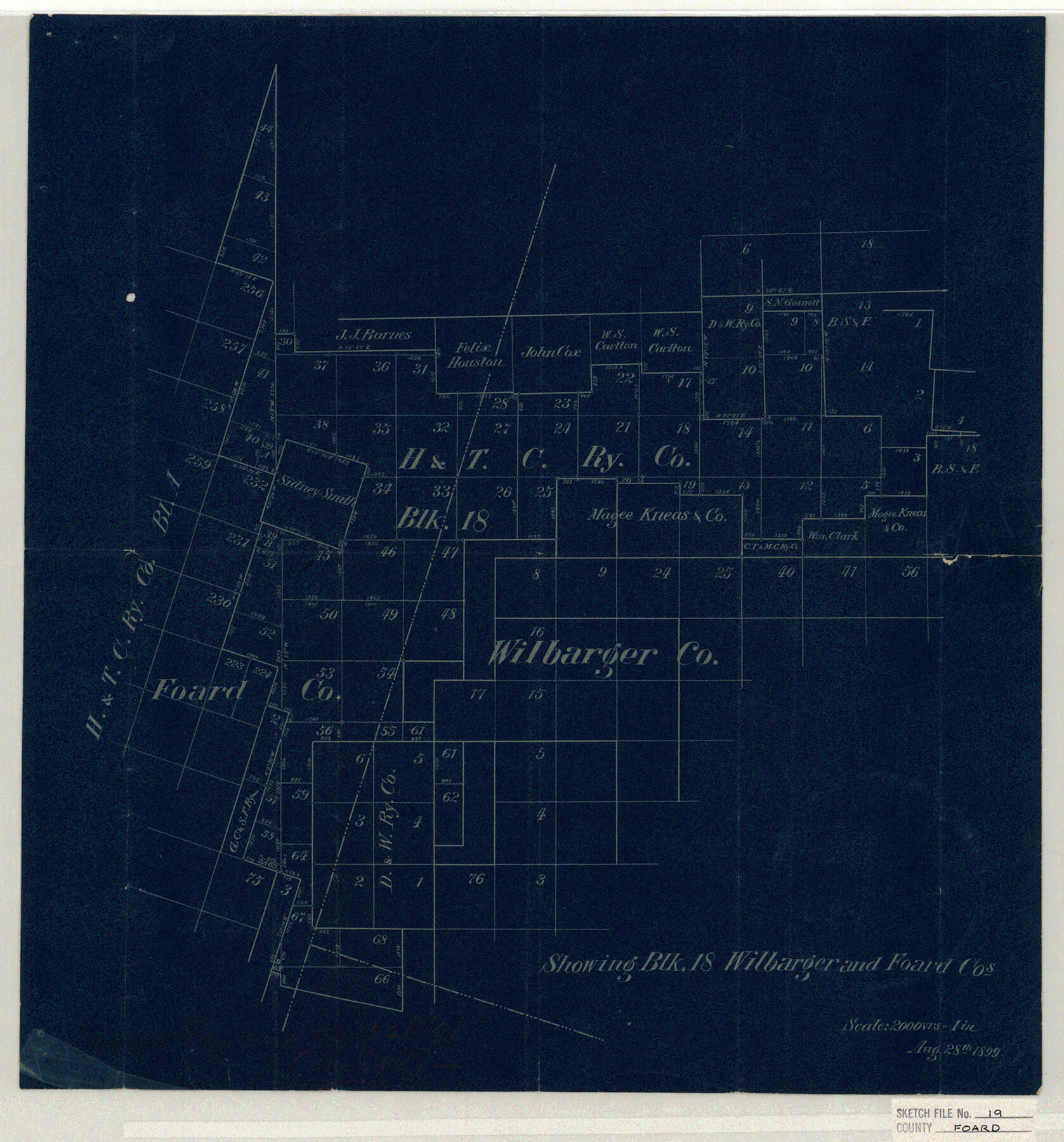
Foard County Sketch File 19
Showing Blk. 18 Wilbarger and Foard Cos.
-
Map/Doc
11493
-
Collection
General Map Collection
-
Object Dates
1899/8/28 (Creation Date)
1900/2/5 (File Date)
-
People and Organizations
Gibbs (Surveyor/Engineer)
-
Counties
Foard Wilbarger
-
Subjects
Surveying Sketch File
-
Height x Width
17.7 x 16.5 inches
45.0 x 41.9 cm
-
Medium
blueprint/diazo
-
Scale
1:2000
Part of: General Map Collection
Irion County Working Sketch 5

Print $20.00
- Digital $50.00
Irion County Working Sketch 5
1929
Size 24.3 x 17.9 inches
Map/Doc 66414
Nueces County Sketch File 43

Print $24.00
- Digital $50.00
Nueces County Sketch File 43
1952
Size 14.2 x 8.6 inches
Map/Doc 32635
Wharton County Rolled Sketch 11

Print $20.00
- Digital $50.00
Wharton County Rolled Sketch 11
Size 27.3 x 37.2 inches
Map/Doc 8235
Outer Continental Shelf Leasing Maps (Texas Offshore Operations)

Print $20.00
- Digital $50.00
Outer Continental Shelf Leasing Maps (Texas Offshore Operations)
Size 17.7 x 14.3 inches
Map/Doc 75856
Moore County Working Sketch 8

Print $20.00
- Digital $50.00
Moore County Working Sketch 8
1948
Size 23.2 x 31.8 inches
Map/Doc 71190
Brazoria County Rolled Sketch 49

Print $20.00
- Digital $50.00
Brazoria County Rolled Sketch 49
1948
Size 23.8 x 36.1 inches
Map/Doc 5182
2008 Official Travel Map, Texas

2008 Official Travel Map, Texas
Size 33.5 x 36.4 inches
Map/Doc 94344
[Gulf, Colorado & Santa Fe]
![64590, [Gulf, Colorado & Santa Fe], General Map Collection](https://historictexasmaps.com/wmedia_w700/maps/64590.tif.jpg)
Print $40.00
- Digital $50.00
[Gulf, Colorado & Santa Fe]
1918
Size 31.4 x 117.0 inches
Map/Doc 64590
Flight Mission No. BQR-13K, Frame 23, Brazoria County

Print $20.00
- Digital $50.00
Flight Mission No. BQR-13K, Frame 23, Brazoria County
1952
Size 18.9 x 22.4 inches
Map/Doc 84071
King County Sketch File 11

Print $40.00
- Digital $50.00
King County Sketch File 11
1902
Size 13.7 x 9.1 inches
Map/Doc 29085
Jasper County Boundary File 2

Print $58.00
- Digital $50.00
Jasper County Boundary File 2
Size 9.0 x 8.0 inches
Map/Doc 55469
A Map of the British Empire in America with the French and Spanish Settlements adjacent thereto

Print $20.00
- Digital $50.00
A Map of the British Empire in America with the French and Spanish Settlements adjacent thereto
1733
Size 20.7 x 20.6 inches
Map/Doc 95704
You may also like
Flight Mission No. CGI-4N, Frame 184, Cameron County

Print $20.00
- Digital $50.00
Flight Mission No. CGI-4N, Frame 184, Cameron County
1955
Size 18.7 x 22.3 inches
Map/Doc 84687
Fannin County No. 2 McClure & M. H. Wright's map, Sulphur

Print $2.00
- Digital $50.00
Fannin County No. 2 McClure & M. H. Wright's map, Sulphur
1844
Size 8.4 x 8.1 inches
Map/Doc 69732
Reeves County Working Sketch 64

Print $20.00
- Digital $50.00
Reeves County Working Sketch 64
1984
Size 26.3 x 26.5 inches
Map/Doc 63507
Maps of Gulf Intracoastal Waterway, Texas - Sabine River to the Rio Grande and connecting waterways including ship channels

Print $20.00
- Digital $50.00
Maps of Gulf Intracoastal Waterway, Texas - Sabine River to the Rio Grande and connecting waterways including ship channels
1966
Size 14.5 x 22.2 inches
Map/Doc 61969
Glasscock County Working Sketch 2

Print $20.00
- Digital $50.00
Glasscock County Working Sketch 2
Size 32.0 x 28.0 inches
Map/Doc 63175
Borden County Sketch File 12

Print $24.00
- Digital $50.00
Borden County Sketch File 12
Size 10.8 x 9.1 inches
Map/Doc 14732
Translations of Titles - Austin's Second Contract, Vol. 3

Translations of Titles - Austin's Second Contract, Vol. 3
1841
Map/Doc 94548
Kimble County Sketch File 20

Print $8.00
- Digital $50.00
Kimble County Sketch File 20
1892
Size 3.9 x 6.5 inches
Map/Doc 28957
Zavala County Sketch File 25

Print $4.00
- Digital $50.00
Zavala County Sketch File 25
1886
Size 14.5 x 8.8 inches
Map/Doc 41388
Map of the route of B'vt. Maj. A. Moore's scout, April 11th to June 12th 1869

Print $20.00
Map of the route of B'vt. Maj. A. Moore's scout, April 11th to June 12th 1869
1872
Size 23.6 x 40.9 inches
Map/Doc 93566

Real County Working Sketch 28

Print $20.00
- Digital $50.00
Real County Working Sketch 28
1947
Size 15.7 x 28.3 inches
Map/Doc 71920