Pecos County Sketch File 116
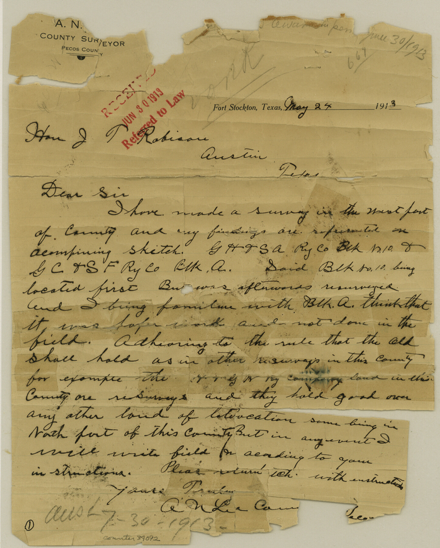
[Correspondence between A.N. Lea and GLO regarding conflict between Block A, G. C. & S. F. R.R. Co. and Block 10, G. H. & S. A. R.R. Co.]
-
Map/Doc
34092
-
Collection
General Map Collection
-
Object Dates
1913/7/30 (Correspondence Date)
1913/5/24 (Correspondence Date)
1913/7/30 (File Date)
1913 (Creation Date)
-
People and Organizations
A.N. Lea (Surveyor/Engineer)
-
Counties
Pecos Brewster
-
Subjects
Surveying Sketch File
-
Height x Width
10.9 x 8.8 inches
27.7 x 22.4 cm
-
Medium
paper, manuscript
-
Comments
See Pecos County Rolled Sketch 50 (7226) for sketch.
Related maps
Pecos County Rolled Sketch 50

Print $20.00
- Digital $50.00
Pecos County Rolled Sketch 50
1913
Size 23.5 x 13.0 inches
Map/Doc 7226
Part of: General Map Collection
Sutton County Working Sketch 58

Print $40.00
- Digital $50.00
Sutton County Working Sketch 58
1958
Size 57.3 x 37.5 inches
Map/Doc 62401
Runnels County Rolled Sketch 53

Print $20.00
- Digital $50.00
Runnels County Rolled Sketch 53
Size 33.1 x 31.1 inches
Map/Doc 7538
Collingsworth County Rolled Sketch 2

Print $20.00
- Digital $50.00
Collingsworth County Rolled Sketch 2
1888
Size 30.2 x 24.8 inches
Map/Doc 5531
Jim Wells County Boundary File 1

Print $22.00
- Digital $50.00
Jim Wells County Boundary File 1
Size 8.9 x 4.3 inches
Map/Doc 55531
Atascosa County Working Sketch 11

Print $20.00
- Digital $50.00
Atascosa County Working Sketch 11
1923
Size 13.9 x 17.1 inches
Map/Doc 67207
Harris County Working Sketch 18

Print $20.00
- Digital $50.00
Harris County Working Sketch 18
1919
Size 12.1 x 14.8 inches
Map/Doc 65910
Lavaca County Working Sketch 19

Print $20.00
- Digital $50.00
Lavaca County Working Sketch 19
1980
Size 26.9 x 29.6 inches
Map/Doc 70372
Chambers County Working Sketch 27

Print $20.00
- Digital $50.00
Chambers County Working Sketch 27
1982
Size 24.9 x 25.2 inches
Map/Doc 68010
Henderson County Rolled Sketch 11

Print $20.00
- Digital $50.00
Henderson County Rolled Sketch 11
1915
Size 29.4 x 42.5 inches
Map/Doc 75946
Culberson County Working Sketch 54

Print $20.00
- Digital $50.00
Culberson County Working Sketch 54
1974
Size 26.4 x 32.6 inches
Map/Doc 68508
Val Verde County Boundary File 2

Print $4.00
- Digital $50.00
Val Verde County Boundary File 2
Size 11.4 x 8.8 inches
Map/Doc 59575
Controlled Mosaic by Jack Amman Photogrammetric Engineers, Inc - Sheet 53

Print $20.00
- Digital $50.00
Controlled Mosaic by Jack Amman Photogrammetric Engineers, Inc - Sheet 53
1954
Size 20.0 x 24.0 inches
Map/Doc 83512
You may also like

Hudspeth County Sketch File 2

Print $10.00
- Digital $50.00
Hudspeth County Sketch File 2
1900
Size 13.4 x 8.6 inches
Map/Doc 26884
Motley County Sketch File 9 (N)

Print $10.00
- Digital $50.00
Motley County Sketch File 9 (N)
1902
Size 11.1 x 8.6 inches
Map/Doc 32019
General Highway Map, Pecos County, Texas

Print $20.00
General Highway Map, Pecos County, Texas
1961
Size 24.5 x 18.1 inches
Map/Doc 79627
Flight Mission No. CRC-3R, Frame 33, Chambers County

Print $20.00
- Digital $50.00
Flight Mission No. CRC-3R, Frame 33, Chambers County
1956
Size 18.6 x 22.4 inches
Map/Doc 84806
County of Galveston, Texas

Print $20.00
- Digital $50.00
County of Galveston, Texas
1845
Size 22.9 x 32.2 inches
Map/Doc 3574
Armstrong County Rolled Sketch B1

Print $20.00
- Digital $50.00
Armstrong County Rolled Sketch B1
1903
Size 25.8 x 37.8 inches
Map/Doc 5085
Wichita County Sketch File 35

Print $8.00
- Digital $50.00
Wichita County Sketch File 35
1950
Size 14.3 x 8.5 inches
Map/Doc 40157
Kimble County Working Sketch 90

Print $20.00
- Digital $50.00
Kimble County Working Sketch 90
1979
Size 17.3 x 28.2 inches
Map/Doc 70158
Ramon de la Garza 11 Leagues Houston and Robertson Districts

Print $2.00
- Digital $50.00
Ramon de la Garza 11 Leagues Houston and Robertson Districts
Size 11.5 x 8.5 inches
Map/Doc 181
Flight Mission No. BRA-16M, Frame 142, Jefferson County

Print $20.00
- Digital $50.00
Flight Mission No. BRA-16M, Frame 142, Jefferson County
1953
Size 18.5 x 22.2 inches
Map/Doc 85748
Fisher County Working Sketch 12

Print $20.00
- Digital $50.00
Fisher County Working Sketch 12
1956
Size 25.2 x 23.2 inches
Map/Doc 69146