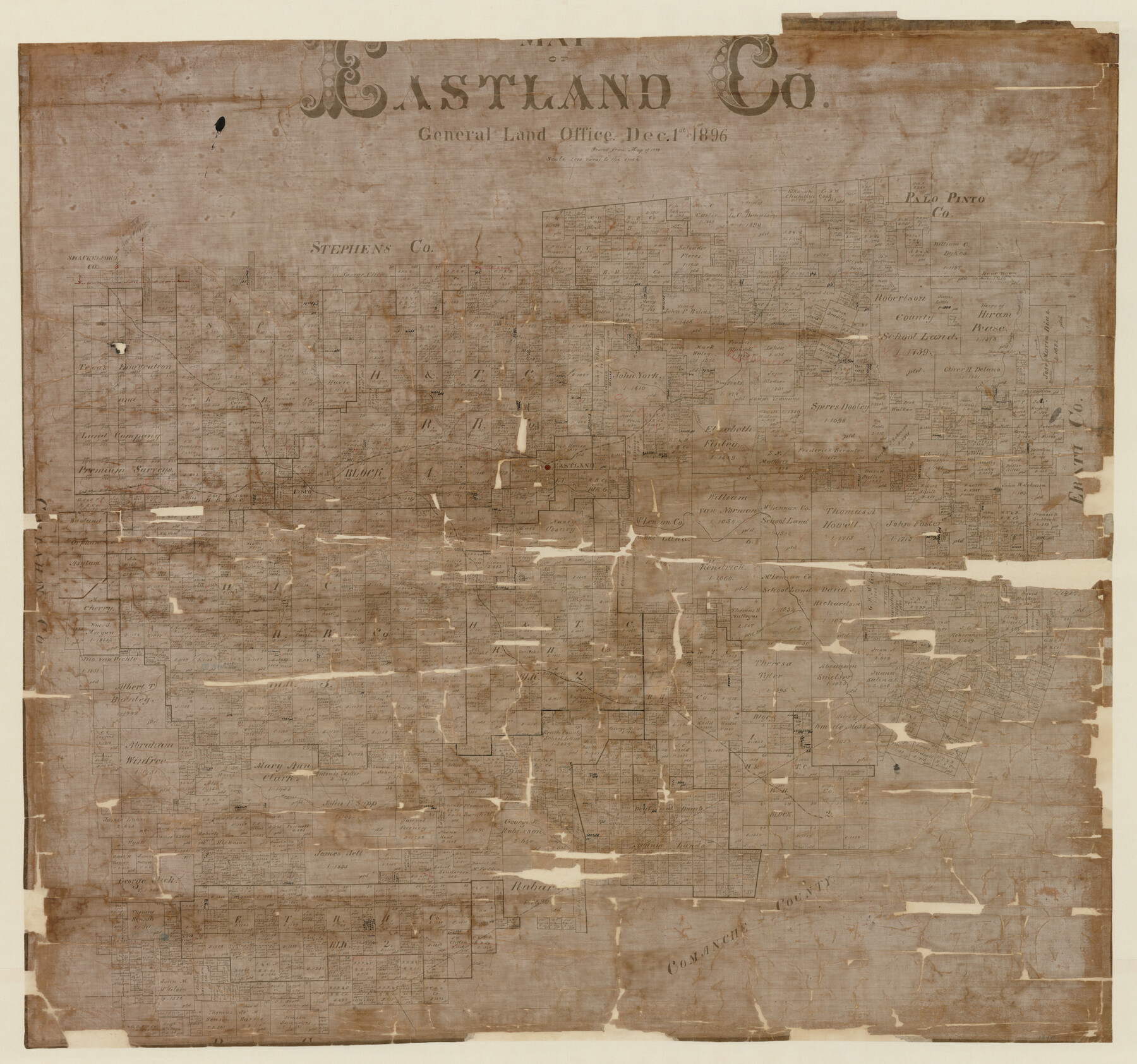
Map of Eastland Co.
-
Map/Doc
78411
-
Collection
General Map Collection
-
Object Dates
1896/12/1 (Creation Date)
-
People and Organizations
Texas General Land Office (Publisher)
John W. Maxcy (Draftsman)
John W. Maxcy (Compiler)
-
Counties
Eastland
-
Subjects
County
-
Height x Width
40.0 x 42.8 inches
101.6 x 108.7 cm
-
Comments
Traced from map of 1889.
Copy 2.
Help Save Texas History - Adopt Me! -
Features
Cisco
Hunting Shirt Creek
Palo Pinta [sic] Creek
Red Haw Creek
Pioneer
Elm Creek
Sabanos Creek
Waynes Creek
H&TC
Flat Creek
Nash's Creek
Gorman
Leon River
Kellars Creek
Hubbards Creek
Bull Run Creek
Colony Creek
Eastland
North Creek
T&P
Rising Star
South Palo Pinta [sic] Creek
Bushis [sic] Creek
Gonzales Creek
Duck Creek
Forty Five Mile Creek
Panther Creek
West Pecan Creek
Part of: General Map Collection
Calhoun County NRC Article 33.136 Sketch 14

Print $24.00
Calhoun County NRC Article 33.136 Sketch 14
2023
Map/Doc 97273
Houston County Working Sketch 2

Print $20.00
- Digital $50.00
Houston County Working Sketch 2
Size 16.1 x 18.6 inches
Map/Doc 66232
Bandera County Rolled Sketch 9

Print $20.00
- Digital $50.00
Bandera County Rolled Sketch 9
Size 21.2 x 24.2 inches
Map/Doc 5120
Parker County Working Sketch 11

Print $20.00
- Digital $50.00
Parker County Working Sketch 11
1969
Map/Doc 71461
Travis County Rolled Sketch 14

Print $20.00
- Digital $50.00
Travis County Rolled Sketch 14
1939
Size 30.5 x 22.3 inches
Map/Doc 8017
Flight Mission No. DAG-21K, Frame 90, Matagorda County

Print $20.00
- Digital $50.00
Flight Mission No. DAG-21K, Frame 90, Matagorda County
1952
Size 18.5 x 22.2 inches
Map/Doc 86419
Orange County Working Sketch 48

Print $20.00
- Digital $50.00
Orange County Working Sketch 48
1991
Size 13.3 x 19.9 inches
Map/Doc 71380
Moore County Working Sketch 8

Print $20.00
- Digital $50.00
Moore County Working Sketch 8
1948
Size 23.2 x 31.8 inches
Map/Doc 71190

Erath County Sketch File 16a

Print $4.00
- Digital $50.00
Erath County Sketch File 16a
1874
Size 12.7 x 8.1 inches
Map/Doc 22296

Real County Working Sketch 77

Print $20.00
- Digital $50.00
Real County Working Sketch 77
1980
Size 33.1 x 33.3 inches
Map/Doc 71969
You may also like
Nueces County Rolled Sketch 131

Print $20.00
- Digital $50.00
Nueces County Rolled Sketch 131
2000
Size 24.2 x 36.6 inches
Map/Doc 7166

Working Sketch in Travis County

Print $20.00
- Digital $50.00
Working Sketch in Travis County
1923
Size 15.4 x 18.6 inches
Map/Doc 91866
Pecos County Sketch File 41

Print $32.00
- Digital $50.00
Pecos County Sketch File 41
1919
Size 11.2 x 8.8 inches
Map/Doc 33729

Kendall County Working Sketch 6

Print $20.00
- Digital $50.00
Kendall County Working Sketch 6
1947
Size 42.6 x 24.8 inches
Map/Doc 66678
Navigation Maps of Gulf Intracoastal Waterway, Port Arthur to Brownsville, Texas

Print $4.00
- Digital $50.00
Navigation Maps of Gulf Intracoastal Waterway, Port Arthur to Brownsville, Texas
1951
Size 16.7 x 21.6 inches
Map/Doc 65447
Crockett County Sketch File D

Print $40.00
- Digital $50.00
Crockett County Sketch File D
1903
Size 24.6 x 48.0 inches
Map/Doc 10347
Frio County Sketch File 23

Print $6.00
- Digital $50.00
Frio County Sketch File 23
2013
Size 11.0 x 8.5 inches
Map/Doc 93418
Dr. Ross Trigg's Ranch [Block 29E, Townships 14N and 15N]
![92036, Dr. Ross Trigg's Ranch [Block 29E, Townships 14N and 15N], Twichell Survey Records](https://historictexasmaps.com/wmedia_w700/maps/92036-1.tif.jpg)
Print $20.00
- Digital $50.00
Dr. Ross Trigg's Ranch [Block 29E, Townships 14N and 15N]
Size 25.8 x 19.6 inches
Map/Doc 92036

General Highway Map, Live Oak County, Texas

Print $20.00
General Highway Map, Live Oak County, Texas
1940
Size 18.5 x 24.8 inches
Map/Doc 79176