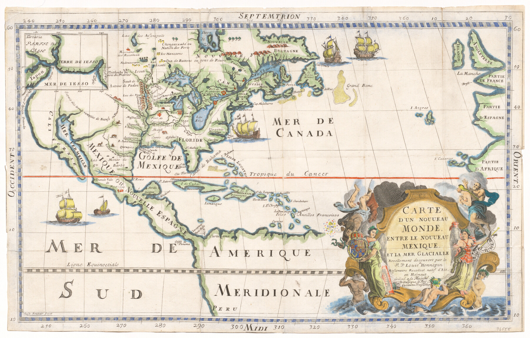
Carte d'un Nouveau Monde, entre le Nouveau Mexique, et la Mer Glacialle
-
Map/Doc
96555
-
Collection
General Map Collection
-
Object Dates
1698 (Publication Date)
-
People and Organizations
Louis de Hennepin (Cartographer)
-
Subjects
North America
-
Height x Width
11.5 x 18.1 inches
29.2 x 46.0 cm
-
Medium
paper, etching/engraving/lithograph
Part of: General Map Collection
[Map of the City of Austin]
![4802, [Map of the City of Austin], General Map Collection](https://historictexasmaps.com/wmedia_w700/maps/4802-1.tif.jpg)
Print $20.00
- Digital $50.00
[Map of the City of Austin]
1856
Size 29.1 x 21.5 inches
Map/Doc 4802
Gaines County Sketch File 13

Print $40.00
- Digital $50.00
Gaines County Sketch File 13
1954
Size 8.9 x 20.4 inches
Map/Doc 23200
Williamson County Sketch File 29

Print $18.00
- Digital $50.00
Williamson County Sketch File 29
Size 10.2 x 8.2 inches
Map/Doc 40377
Harbor Pass and Bar at Brazos Santiago, Texas

Print $20.00
- Digital $50.00
Harbor Pass and Bar at Brazos Santiago, Texas
1871
Size 18.2 x 26.3 inches
Map/Doc 72985
Burnet County Sketch File 39

Print $40.00
- Digital $50.00
Burnet County Sketch File 39
Size 9.6 x 24.1 inches
Map/Doc 11028
McCulloch County Working Sketch 18

Print $20.00
- Digital $50.00
McCulloch County Working Sketch 18
1997
Size 42.9 x 32.8 inches
Map/Doc 70693
Reeves County Sketch File 6

Print $20.00
- Digital $50.00
Reeves County Sketch File 6
Size 17.3 x 28.3 inches
Map/Doc 12242
Bowie County Sketch File 9

Print $10.00
- Digital $50.00
Bowie County Sketch File 9
Size 8.1 x 3.9 inches
Map/Doc 14907
Flight Mission No. DIX-6P, Frame 117, Aransas County

Print $20.00
- Digital $50.00
Flight Mission No. DIX-6P, Frame 117, Aransas County
1956
Size 19.2 x 22.8 inches
Map/Doc 83823
West Half - Brown County

Print $40.00
- Digital $50.00
West Half - Brown County
1982
Size 142.2 x 37.3 inches
Map/Doc 97384
Supreme Court of the United States, October Term, 1924, No. 13, Original - The State of Oklahoma, Complainant vs. The State of Texas, Defendant, The United States, Intervener

Print $20.00
- Digital $50.00
Supreme Court of the United States, October Term, 1924, No. 13, Original - The State of Oklahoma, Complainant vs. The State of Texas, Defendant, The United States, Intervener
1924
Size 16.5 x 33.1 inches
Map/Doc 75113
Oldham County

Print $40.00
- Digital $50.00
Oldham County
1925
Size 43.6 x 53.5 inches
Map/Doc 66960
You may also like
Kenedy County Rolled Sketch 4

Print $40.00
- Digital $50.00
Kenedy County Rolled Sketch 4
1904
Size 39.4 x 57.6 inches
Map/Doc 10654
Austin County Rolled Sketch 7

Print $47.00
- Digital $50.00
Austin County Rolled Sketch 7
1974
Size 10.4 x 15.3 inches
Map/Doc 42340

Travis County Appraisal District Plat Map 1_1808

Print $20.00
- Digital $50.00
Travis County Appraisal District Plat Map 1_1808
Size 21.5 x 26.5 inches
Map/Doc 94214
Upton County Rolled Sketch 57

Print $20.00
- Digital $50.00
Upton County Rolled Sketch 57
Size 30.1 x 41.8 inches
Map/Doc 8090
Flight Mission No. DQO-2K, Frame 144, Galveston County

Print $20.00
- Digital $50.00
Flight Mission No. DQO-2K, Frame 144, Galveston County
1952
Size 18.8 x 22.5 inches
Map/Doc 85041
Crosby County Sketch File 27

Print $20.00
- Digital $50.00
Crosby County Sketch File 27
Size 8.8 x 23.0 inches
Map/Doc 11256
Crockett County Rolled Sketch 83

Print $20.00
- Digital $50.00
Crockett County Rolled Sketch 83
1960
Size 22.6 x 15.2 inches
Map/Doc 5623
Webb County Working Sketch 50

Print $20.00
- Digital $50.00
Webb County Working Sketch 50
1950
Size 22.9 x 24.9 inches
Map/Doc 72415
Flight Mission No. BRE-1P, Frame 102, Nueces County

Print $20.00
- Digital $50.00
Flight Mission No. BRE-1P, Frame 102, Nueces County
1956
Size 18.5 x 22.4 inches
Map/Doc 86673
Knox County Boundary File 1a

Print $16.00
- Digital $50.00
Knox County Boundary File 1a
Size 9.7 x 13.8 inches
Map/Doc 65010
[H. & G. N. Block 1, Sections 128-130]
![90948, [H. & G. N. Block 1, Sections 128-130], Twichell Survey Records](https://historictexasmaps.com/wmedia_w700/maps/90948-1.tif.jpg)
Print $20.00
- Digital $50.00
[H. & G. N. Block 1, Sections 128-130]
Size 36.6 x 11.9 inches
Map/Doc 90948