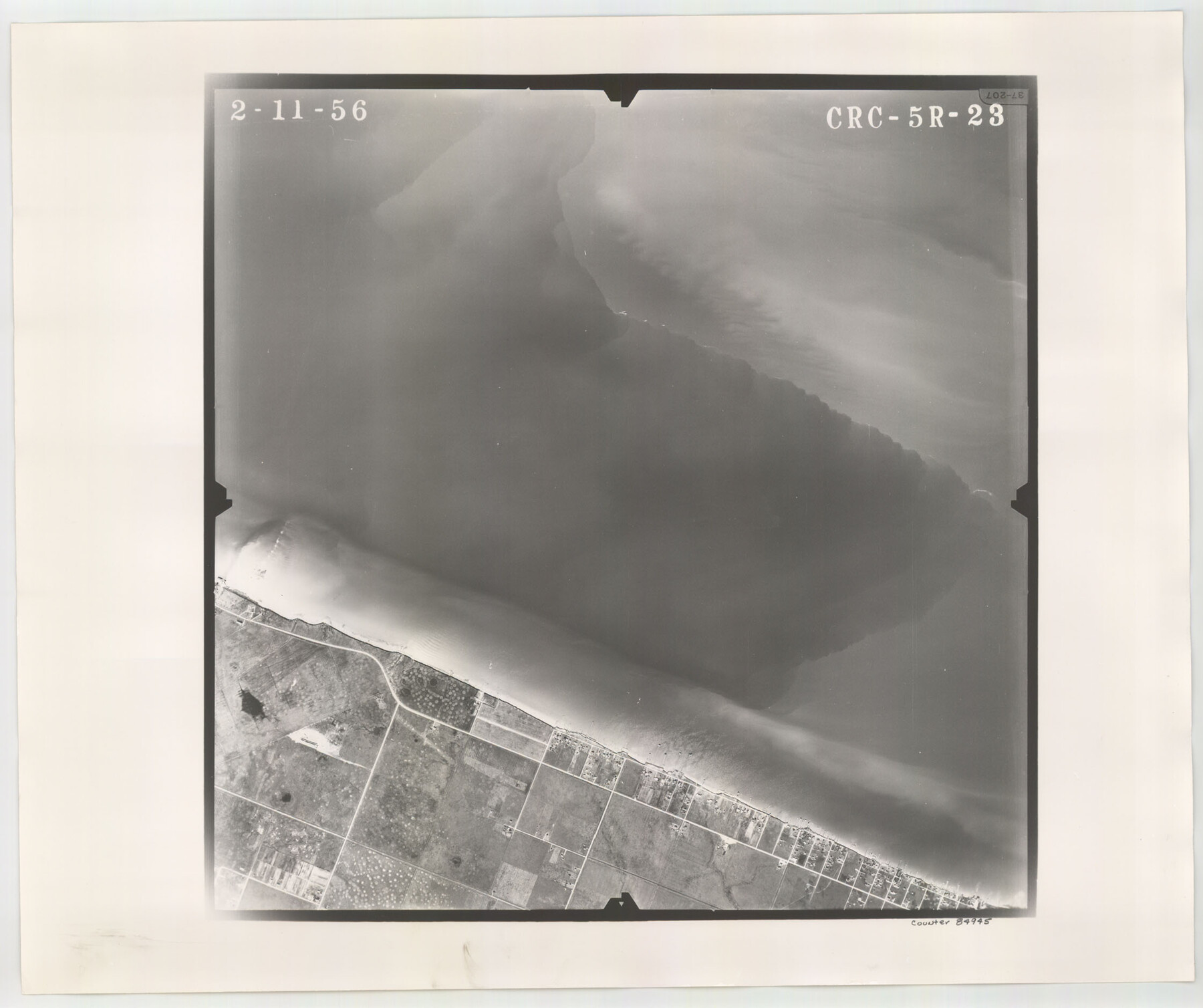
Flight Mission No. CRC-5R, Frame 23, Chambers County
CRC-5R-23
-
Map/Doc
84945
-
Collection
General Map Collection
-
Object Dates
1956/2/11 (Creation Date)
-
People and Organizations
U. S. Department of Agriculture (Publisher)
-
Counties
Chambers
-
Subjects
Aerial Photograph
-
Height x Width
18.8 x 22.4 inches
47.8 x 56.9 cm
-
Comments
Flown by Jack Ammann Photogrammetric Engineers, Inc. of San Antonio, Texas.
Part of: General Map Collection
Randall County Rolled Sketch 6

Print $20.00
- Digital $50.00
Randall County Rolled Sketch 6
Size 25.0 x 23.9 inches
Map/Doc 7426
Right of Way and Track Map of The Missouri, Kansas & Texas Railway of Texas

Print $40.00
- Digital $50.00
Right of Way and Track Map of The Missouri, Kansas & Texas Railway of Texas
1918
Size 25.9 x 108.3 inches
Map/Doc 64526
Hood County Working Sketch 7

Print $20.00
- Digital $50.00
Hood County Working Sketch 7
1970
Size 29.4 x 31.2 inches
Map/Doc 66201
Flight Mission No. DQO-7K, Frame 98, Galveston County

Print $20.00
- Digital $50.00
Flight Mission No. DQO-7K, Frame 98, Galveston County
1952
Size 18.8 x 22.4 inches
Map/Doc 85113
Dawson County Sketch File 9

Print $4.00
- Digital $50.00
Dawson County Sketch File 9
1925
Size 11.3 x 8.7 inches
Map/Doc 20542
PSL Field Notes for Blocks B13, B18, and B28 in Crane and Ward Counties, and Blocks B19, B20, and B29 in Ward County

PSL Field Notes for Blocks B13, B18, and B28 in Crane and Ward Counties, and Blocks B19, B20, and B29 in Ward County
Map/Doc 81647
Cottle County Sketch File 10

Print $20.00
- Digital $50.00
Cottle County Sketch File 10
Size 15.7 x 23.1 inches
Map/Doc 11193
Dimmit County Working Sketch 56

Print $20.00
- Digital $50.00
Dimmit County Working Sketch 56
1990
Size 23.0 x 29.0 inches
Map/Doc 68717
North Sulphur River, Sims Crossing Sheet

Print $20.00
- Digital $50.00
North Sulphur River, Sims Crossing Sheet
1924
Size 23.4 x 39.9 inches
Map/Doc 65167
Shackelford County Boundary File 2

Print $88.00
- Digital $50.00
Shackelford County Boundary File 2
Size 8.7 x 5.3 inches
Map/Doc 58633
Flight Mission No. DAG-19K, Frame 65, Matagorda County

Print $20.00
- Digital $50.00
Flight Mission No. DAG-19K, Frame 65, Matagorda County
1952
Size 18.5 x 22.3 inches
Map/Doc 86392
Lubbock County Sketch File 2

Print $4.00
- Digital $50.00
Lubbock County Sketch File 2
Size 4.7 x 9.2 inches
Map/Doc 30418
You may also like
English Field Notes of the Spanish Archives - Book 12

English Field Notes of the Spanish Archives - Book 12
1832
Map/Doc 96538
Bell County Working Sketch 13

Print $20.00
- Digital $50.00
Bell County Working Sketch 13
1964
Size 19.6 x 18.5 inches
Map/Doc 67353
General Highway Map. Detail of Cities and Towns in Potter County, Texas [Amarillo and vicinity]
![79221, General Highway Map. Detail of Cities and Towns in Potter County, Texas [Amarillo and vicinity], Texas State Library and Archives](https://historictexasmaps.com/wmedia_w700/maps/79221.tif.jpg)
Print $20.00
General Highway Map. Detail of Cities and Towns in Potter County, Texas [Amarillo and vicinity]
1940
Size 24.6 x 18.2 inches
Map/Doc 79221
Cooke County Working Sketch 20

Print $20.00
- Digital $50.00
Cooke County Working Sketch 20
1956
Size 21.1 x 10.4 inches
Map/Doc 68257
Bandera County Working Sketch 16b

Print $20.00
- Digital $50.00
Bandera County Working Sketch 16b
1941
Size 18.9 x 23.1 inches
Map/Doc 67610
[Portion of sketch showing alleged vacancy]
![91953, [Portion of sketch showing alleged vacancy], Twichell Survey Records](https://historictexasmaps.com/wmedia_w700/maps/91953-1.tif.jpg)
Print $20.00
- Digital $50.00
[Portion of sketch showing alleged vacancy]
Size 18.9 x 24.4 inches
Map/Doc 91953
Flight Mission No. DQN-2K, Frame 136, Calhoun County

Print $20.00
- Digital $50.00
Flight Mission No. DQN-2K, Frame 136, Calhoun County
1953
Size 18.5 x 15.8 inches
Map/Doc 84305
Upton County Working Sketch 12

Print $40.00
- Digital $50.00
Upton County Working Sketch 12
1937
Size 43.6 x 77.9 inches
Map/Doc 69508
San Augustine County Rolled Sketch 1

Print $20.00
- Digital $50.00
San Augustine County Rolled Sketch 1
1946
Size 19.1 x 30.4 inches
Map/Doc 7553
Sterling County Sketch File 17

Print $8.00
- Digital $50.00
Sterling County Sketch File 17
1936
Size 11.2 x 8.8 inches
Map/Doc 37154
Jackson County Sketch File 10x

Print $40.00
- Digital $50.00
Jackson County Sketch File 10x
1914
Size 13.8 x 12.0 inches
Map/Doc 27656
Potter County Boundary File 4a

Print $80.00
- Digital $50.00
Potter County Boundary File 4a
Size 15.2 x 99.1 inches
Map/Doc 58011