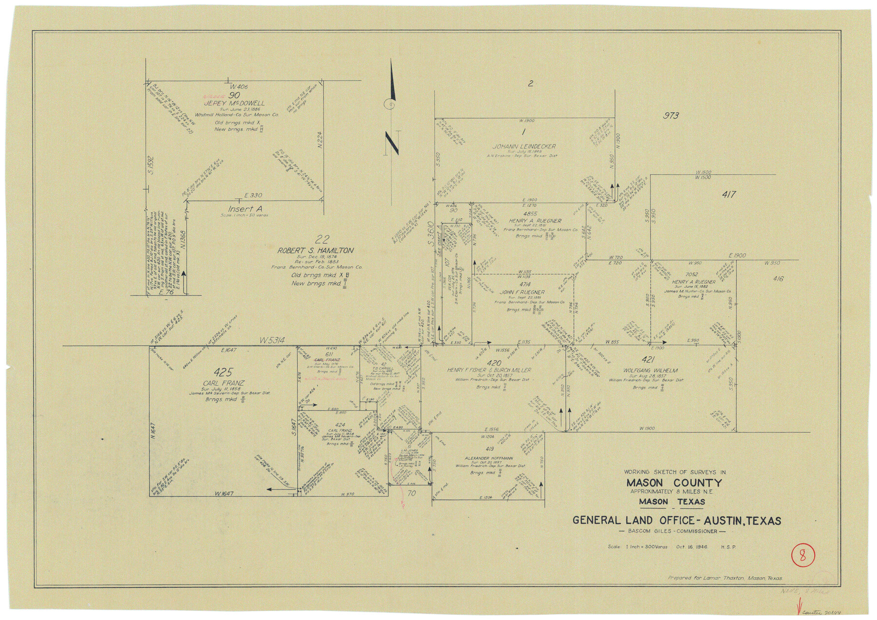
Mason County Working Sketch 8
-
Map/Doc
70844
-
Collection
General Map Collection
-
Object Dates
10/16/1946 (Creation Date)
-
Counties
Mason
-
Subjects
Surveying Working Sketch
-
Height x Width
22.9 x 32.3 inches
58.2 x 82.0 cm
-
Scale
1" = 300 varas
Part of: General Map Collection
Henderson County Working Sketch 20

Print $20.00
- Digital $50.00
Henderson County Working Sketch 20
1947
Size 31.6 x 18.9 inches
Map/Doc 66153
Wharton County Sketch File 26

Print $4.00
- Digital $50.00
Wharton County Sketch File 26
1895
Size 11.0 x 8.8 inches
Map/Doc 39990
Map of Potter County

Print $20.00
- Digital $50.00
Map of Potter County
1895
Size 27.0 x 21.1 inches
Map/Doc 3966
King County Boundary File 1

Print $46.00
- Digital $50.00
King County Boundary File 1
Size 14.2 x 8.6 inches
Map/Doc 64873
Sutton County Rolled Sketch 69

Print $20.00
- Digital $50.00
Sutton County Rolled Sketch 69
Size 39.7 x 36.6 inches
Map/Doc 9981
Lipscomb County Boundary File 5

Print $4.00
- Digital $50.00
Lipscomb County Boundary File 5
Size 5.5 x 8.6 inches
Map/Doc 56327
Flight Mission No. DAG-17K, Frame 126, Matagorda County

Print $20.00
- Digital $50.00
Flight Mission No. DAG-17K, Frame 126, Matagorda County
1952
Size 18.6 x 22.3 inches
Map/Doc 86346
[Sketch for Mineral Application 24072, San Jacinto River]
![65597, [Sketch for Mineral Application 24072, San Jacinto River], General Map Collection](https://historictexasmaps.com/wmedia_w700/maps/65597.tif.jpg)
Print $20.00
- Digital $50.00
[Sketch for Mineral Application 24072, San Jacinto River]
1929
Size 24.6 x 18.4 inches
Map/Doc 65597
Nueces County Sketch File 72

Print $13.00
- Digital $50.00
Nueces County Sketch File 72
1991
Size 11.1 x 8.8 inches
Map/Doc 33020
Harris County NRC Article 33.136 Sketch 19

Print $50.00
- Digital $50.00
Harris County NRC Article 33.136 Sketch 19
2014
Size 24.6 x 36.6 inches
Map/Doc 95334
[Sketch for Mineral Application 27670 - Strip between Simon Sanchez leagues and Trinity River]
![2866, [Sketch for Mineral Application 27670 - Strip between Simon Sanchez leagues and Trinity River], General Map Collection](https://historictexasmaps.com/wmedia_w700/maps/2866-1.tif.jpg)
Print $20.00
- Digital $50.00
[Sketch for Mineral Application 27670 - Strip between Simon Sanchez leagues and Trinity River]
1934
Size 17.3 x 36.7 inches
Map/Doc 2866
Hutchinson County Working Sketch 22

Print $40.00
- Digital $50.00
Hutchinson County Working Sketch 22
1966
Size 67.9 x 35.5 inches
Map/Doc 66382
You may also like
Map of Hays County

Print $20.00
- Digital $50.00
Map of Hays County
1880
Size 26.0 x 21.8 inches
Map/Doc 4562
Right of Way and Track Map, the Missouri, Kansas and Texas Ry. of Texas operated by the Missouri, Kansas and Texas Ry. of Texas, San Antonio Division

Print $40.00
- Digital $50.00
Right of Way and Track Map, the Missouri, Kansas and Texas Ry. of Texas operated by the Missouri, Kansas and Texas Ry. of Texas, San Antonio Division
1918
Size 25.1 x 57.7 inches
Map/Doc 64585
The North Coast of the Gulf of Mexico from St. Marks to Galveston

Print $20.00
- Digital $50.00
The North Coast of the Gulf of Mexico from St. Marks to Galveston
1844
Size 27.5 x 41.1 inches
Map/Doc 97396
Flight Mission No. DQO-3K, Frame 34, Galveston County

Print $20.00
- Digital $50.00
Flight Mission No. DQO-3K, Frame 34, Galveston County
1952
Size 18.7 x 22.4 inches
Map/Doc 85075
Newton County Rolled Sketch 19

Print $20.00
- Digital $50.00
Newton County Rolled Sketch 19
1956
Size 42.1 x 33.5 inches
Map/Doc 6848

Texas since 1850

Print $20.00
- Digital $50.00
Texas since 1850
1897
Size 13.3 x 15.5 inches
Map/Doc 93413
Cooke County Sketch File 14

Print $4.00
- Digital $50.00
Cooke County Sketch File 14
Size 10.3 x 8.2 inches
Map/Doc 19248
Sketch E. No. 2 Shewing the progress of the Survey in the vicinity of Savannah, Georgia

Print $20.00
- Digital $50.00
Sketch E. No. 2 Shewing the progress of the Survey in the vicinity of Savannah, Georgia
1850
Size 11.0 x 9.9 inches
Map/Doc 97214
Freestone County Sketch File 13

Print $4.00
- Digital $50.00
Freestone County Sketch File 13
1860
Size 8.3 x 8.1 inches
Map/Doc 23063
[Travis Station Map - Tracks and Structures - Lands. San Antonio & Aransas Pass Railway Co.]
![62564, [Travis Station Map - Tracks and Structures - Lands. San Antonio & Aransas Pass Railway Co.], General Map Collection](https://historictexasmaps.com/wmedia_w700/maps/62564.tif.jpg)
Print $4.00
- Digital $50.00
[Travis Station Map - Tracks and Structures - Lands. San Antonio & Aransas Pass Railway Co.]
1919
Size 11.7 x 18.7 inches
Map/Doc 62564
Culberson County Sketch File 24

Print $34.00
- Digital $50.00
Culberson County Sketch File 24
1934
Size 11.2 x 9.0 inches
Map/Doc 20242