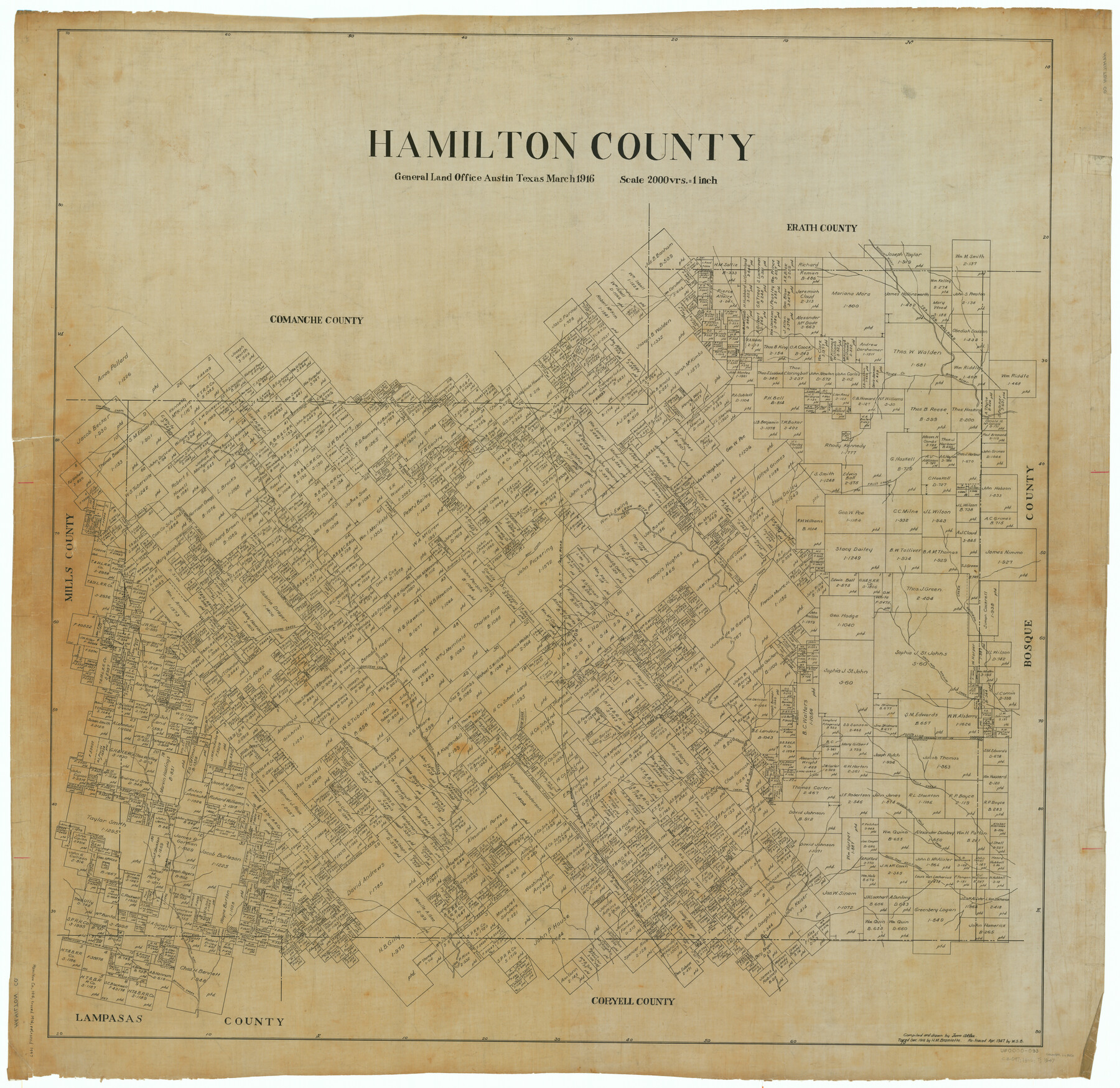
Hamilton County
-
Map/Doc
66850
-
Collection
General Map Collection
-
Object Dates
3/1916 (Creation Date)
12/1916 (Tracing Date)
4/1947 (Tracing Date)
-
People and Organizations
Tom G. Atlee (Draftsman)
H.M. Bramlette (Tracer)
W. S. Brewington (Tracer)
-
Counties
Hamilton
-
Subjects
County
-
Height x Width
42.3 x 43.2 inches
107.4 x 109.7 cm
Part of: General Map Collection
Flight Mission No. DQN-3K, Frame 65, Calhoun County

Print $20.00
- Digital $50.00
Flight Mission No. DQN-3K, Frame 65, Calhoun County
1953
Size 16.2 x 16.1 inches
Map/Doc 84356
Aransas County Sketch File 35

Print $61.00
- Digital $50.00
Aransas County Sketch File 35
1984
Size 11.0 x 8.8 inches
Map/Doc 13347
Orange County Rolled Sketch 31

Print $40.00
- Digital $50.00
Orange County Rolled Sketch 31
1926
Size 88.7 x 35.2 inches
Map/Doc 9651
Trinity County Sketch File 36

Print $20.00
- Digital $50.00
Trinity County Sketch File 36
Size 43.4 x 18.1 inches
Map/Doc 10408
Coke County Rolled Sketch 14

Print $20.00
- Digital $50.00
Coke County Rolled Sketch 14
Size 26.8 x 18.9 inches
Map/Doc 5514

Burnet County Sketch File 39

Print $40.00
- Digital $50.00
Burnet County Sketch File 39
Size 9.6 x 24.1 inches
Map/Doc 11028
Map of Cottle County

Print $20.00
- Digital $50.00
Map of Cottle County
1893
Size 23.1 x 19.4 inches
Map/Doc 3451
Goliad County Sketch File 19

Print $10.00
- Digital $50.00
Goliad County Sketch File 19
Size 12.9 x 8.0 inches
Map/Doc 24260
Upton County Sketch File 40

Print $6.00
- Digital $50.00
Upton County Sketch File 40
1961
Size 11.5 x 8.7 inches
Map/Doc 38914
Brewster County Working Sketch 86

Print $20.00
- Digital $50.00
Brewster County Working Sketch 86
1973
Size 27.6 x 27.7 inches
Map/Doc 67686
Hudspeth County Working Sketch 27

Print $40.00
- Digital $50.00
Hudspeth County Working Sketch 27
1972
Size 31.0 x 51.2 inches
Map/Doc 66309
You may also like
Montgomery County Working Sketch 3

Print $20.00
- Digital $50.00
Montgomery County Working Sketch 3
1918
Size 16.5 x 14.1 inches
Map/Doc 71109
Map of the United States and Canada designed to accompany Smith's Geography for Schools

Print $20.00
- Digital $50.00
Map of the United States and Canada designed to accompany Smith's Geography for Schools
1850
Size 12.1 x 19.2 inches
Map/Doc 93884
Station Map, the Missouri, Kansas and Texas Ry. Of Texas - Henrietta Division

Print $20.00
- Digital $50.00
Station Map, the Missouri, Kansas and Texas Ry. Of Texas - Henrietta Division
1918
Size 11.7 x 26.8 inches
Map/Doc 64764
Brewster County Working Sketch 46

Print $20.00
- Digital $50.00
Brewster County Working Sketch 46
1948
Size 37.6 x 33.6 inches
Map/Doc 67580
Webb County Rolled Sketch 29

Print $20.00
- Digital $50.00
Webb County Rolled Sketch 29
1932
Size 16.5 x 15.3 inches
Map/Doc 8187
Brewster County Rolled Sketch 93

Print $20.00
- Digital $50.00
Brewster County Rolled Sketch 93
1935
Size 24.1 x 43.1 inches
Map/Doc 5251
Hudspeth County Working Sketch 45

Print $20.00
- Digital $50.00
Hudspeth County Working Sketch 45
1983
Size 34.7 x 43.2 inches
Map/Doc 66330
Limestone County Sketch File 17

Print $10.00
- Digital $50.00
Limestone County Sketch File 17
Size 14.4 x 8.7 inches
Map/Doc 30187
Matagorda County NRC Article 33.136 Sketch 12

Print $32.00
- Digital $50.00
Matagorda County NRC Article 33.136 Sketch 12
2017
Size 22.0 x 34.0 inches
Map/Doc 94780
Brazoria County NRC Article 33.136 Sketch 12

Print $26.00
- Digital $50.00
Brazoria County NRC Article 33.136 Sketch 12
2010
Size 21.0 x 34.0 inches
Map/Doc 93407
Brewster County Rolled Sketch 94

Print $40.00
- Digital $50.00
Brewster County Rolled Sketch 94
1941
Size 26.8 x 58.6 inches
Map/Doc 8507
Flight Mission No. BRE-1P, Frame 93, Nueces County

Print $20.00
- Digital $50.00
Flight Mission No. BRE-1P, Frame 93, Nueces County
1956
Size 18.5 x 22.2 inches
Map/Doc 86664