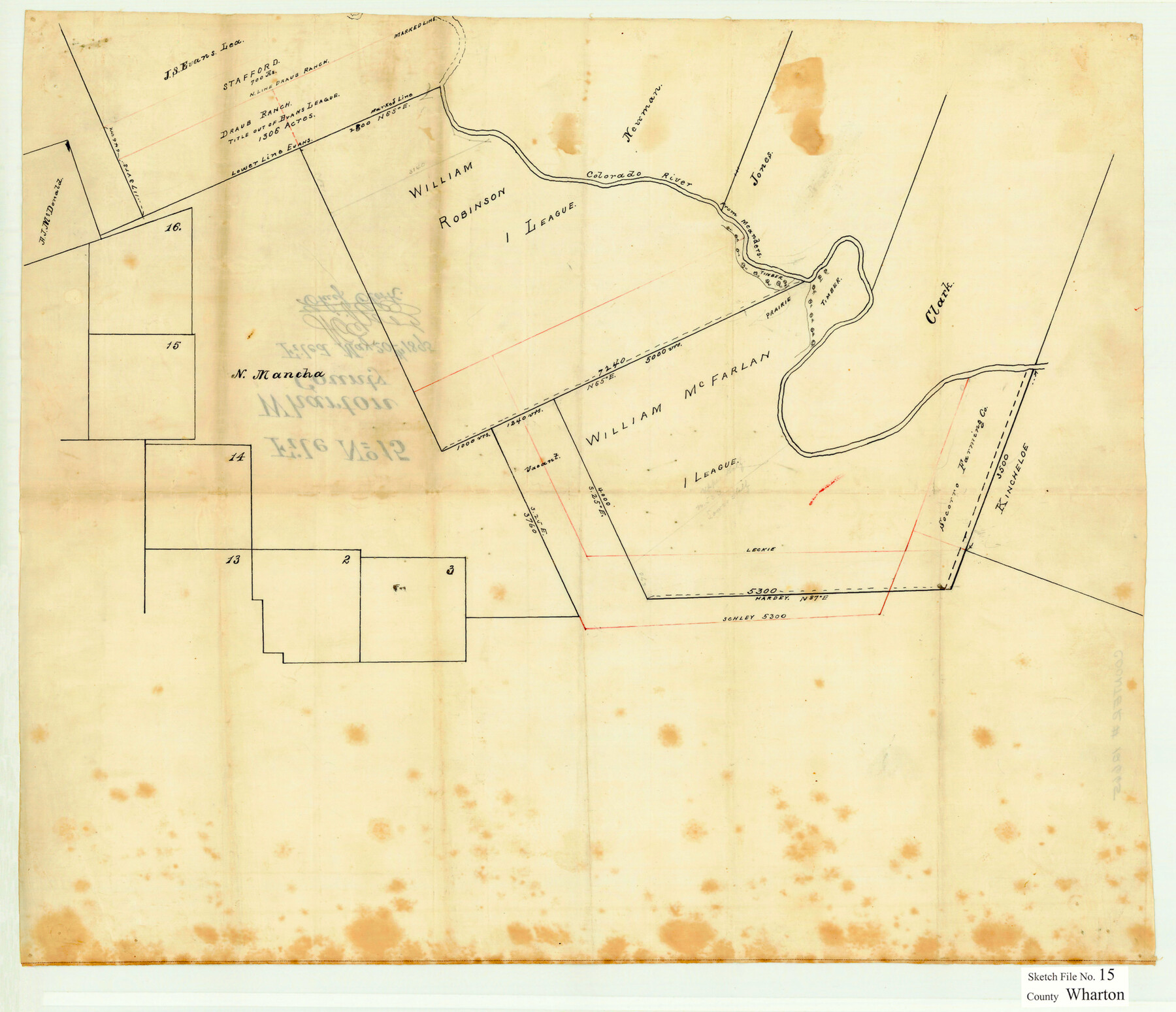
Wharton County Sketch File 15
[Sketch of the William Robinson and William McFarlan leagues and surrounding area west of Wharton]
-
Map/Doc
12665
-
Collection
General Map Collection
-
Object Dates
5/20/1895 (File Date)
-
Counties
Wharton
-
Subjects
Surveying Sketch File
-
Height x Width
18.2 x 21.1 inches
46.2 x 53.6 cm
-
Medium
paper, manuscript
-
Features
Colorado River
Part of: General Map Collection
Smith County Rolled Sketch 6C

Print $20.00
- Digital $50.00
Smith County Rolled Sketch 6C
1943
Size 25.7 x 34.4 inches
Map/Doc 10701
Jim Hogg County Sketch File 8

Print $20.00
- Digital $50.00
Jim Hogg County Sketch File 8
1941
Size 21.9 x 27.0 inches
Map/Doc 11887
Bee County Working Sketch 8

Print $20.00
- Digital $50.00
Bee County Working Sketch 8
1939
Size 18.0 x 20.5 inches
Map/Doc 67258
Presidio County Sketch File 116

Print $86.00
- Digital $50.00
Presidio County Sketch File 116
1993
Size 11.4 x 8.7 inches
Map/Doc 34842
Cottle County

Print $20.00
- Digital $50.00
Cottle County
1908
Size 45.0 x 41.0 inches
Map/Doc 66789
Fort Bend County Sketch File 25

Print $20.00
- Digital $50.00
Fort Bend County Sketch File 25
Size 17.3 x 16.5 inches
Map/Doc 11510
Chambers County Sketch File 56

Print $7.00
- Digital $50.00
Chambers County Sketch File 56
Size 14.8 x 8.7 inches
Map/Doc 18099
Real County Working Sketch 87

Print $20.00
- Digital $50.00
Real County Working Sketch 87
1988
Size 30.9 x 29.6 inches
Map/Doc 71979
Meanders of Sulphur Fork of Red River, Red River County, Texas
Print $2.00
- Digital $50.00
Meanders of Sulphur Fork of Red River, Red River County, Texas
1841
Size 9.9 x 8.1 inches
Map/Doc 65789
Sutton County Rolled Sketch 71

Print $20.00
- Digital $50.00
Sutton County Rolled Sketch 71
Size 23.1 x 35.3 inches
Map/Doc 83760
Chambers County Sketch File Y

Print $4.00
- Digital $50.00
Chambers County Sketch File Y
1907
Size 14.3 x 8.7 inches
Map/Doc 17600
Flight Mission No. CRC-5R, Frame 32, Chambers County

Print $20.00
- Digital $50.00
Flight Mission No. CRC-5R, Frame 32, Chambers County
1956
Size 18.5 x 22.4 inches
Map/Doc 84951
You may also like
Right of Way & Track Map, San Antonio & Aransas Pass Railway Co.

Print $40.00
- Digital $50.00
Right of Way & Track Map, San Antonio & Aransas Pass Railway Co.
1919
Size 25.3 x 56.4 inches
Map/Doc 64217
Texas Gulf Coast Bay Index Map

Print $20.00
- Digital $50.00
Texas Gulf Coast Bay Index Map
Size 43.7 x 42.6 inches
Map/Doc 73599
Lamb County Working Sketch 2

Print $20.00
- Digital $50.00
Lamb County Working Sketch 2
1919
Size 13.6 x 15.3 inches
Map/Doc 70275
General Highway Map, El Paso County, Texas

Print $20.00
General Highway Map, El Paso County, Texas
1940
Size 18.4 x 24.7 inches
Map/Doc 79084
Brooks County Working Sketch 16

Print $20.00
- Digital $50.00
Brooks County Working Sketch 16
1972
Size 35.0 x 29.7 inches
Map/Doc 67800
Coleman County

Print $40.00
- Digital $50.00
Coleman County
1945
Size 54.5 x 35.4 inches
Map/Doc 77241
Coryell County Milam District

Print $20.00
- Digital $50.00
Coryell County Milam District
1883
Size 25.7 x 24.6 inches
Map/Doc 3446
Flight Mission No. CZW-1R, Frame 116, Hardeman County

Print $20.00
- Digital $50.00
Flight Mission No. CZW-1R, Frame 116, Hardeman County
1956
Size 18.6 x 19.0 inches
Map/Doc 85235
MacKenzie SP - 52 - T Base Map

Print $20.00
- Digital $50.00
MacKenzie SP - 52 - T Base Map
1935
Size 36.9 x 24.9 inches
Map/Doc 92802
Map of [Coleman County]
![3413, Map of [Coleman County], General Map Collection](https://historictexasmaps.com/wmedia_w700/maps/3413-1.tif.jpg)
Print $20.00
- Digital $50.00
Map of [Coleman County]
1878
Size 24.9 x 21.9 inches
Map/Doc 3413
Rockwall County Boundary File 6

Print $48.00
- Digital $50.00
Rockwall County Boundary File 6
Size 14.0 x 8.6 inches
Map/Doc 58420
The Republic County of Bexar. November 28, 1839

Print $20.00
The Republic County of Bexar. November 28, 1839
2020
Size 14.8 x 21.1 inches
Map/Doc 96097