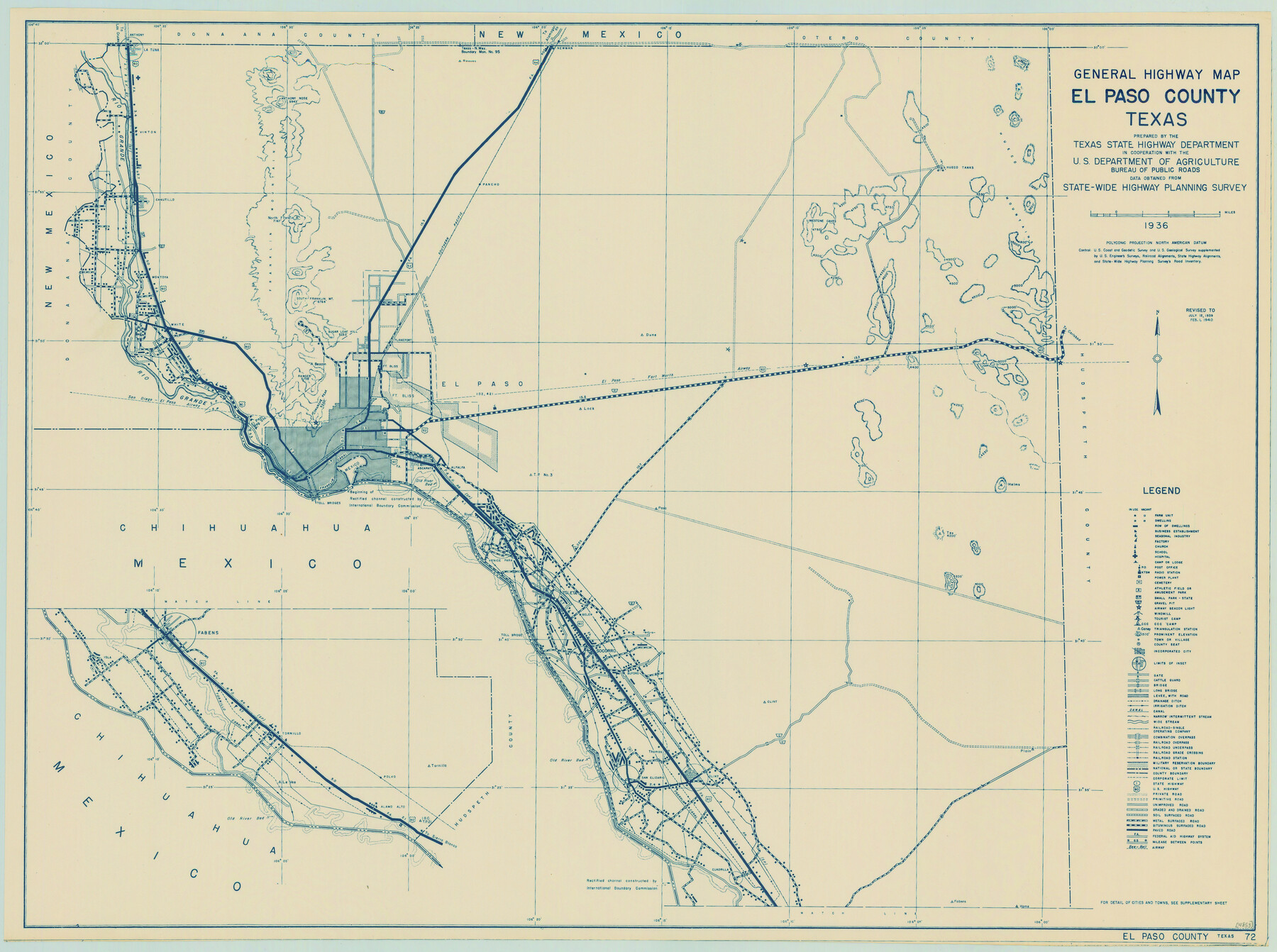
General Highway Map, El Paso County, Texas
-
Map/Doc
79084
-
Collection
Texas State Library and Archives
-
Object Dates
1940 (Creation Date)
-
People and Organizations
Texas State Highway Department (Publisher)
-
Counties
El Paso
-
Subjects
County
-
Height x Width
18.4 x 24.7 inches
46.7 x 62.7 cm
-
Comments
Prints available courtesy of the Texas State Library and Archives.
More info can be found here: TSLAC Map 04853
Part of: Texas State Library and Archives
General Highway Map, Williamson County, Texas

Print $20.00
General Highway Map, Williamson County, Texas
1940
Size 24.8 x 18.4 inches
Map/Doc 79280
General Highway Map, Johnson County, Texas

Print $20.00
General Highway Map, Johnson County, Texas
1961
Size 18.2 x 24.8 inches
Map/Doc 79545
General Highway Map, Jasper County, Newton County, Texas

Print $20.00
General Highway Map, Jasper County, Newton County, Texas
1940
Size 18.6 x 25.0 inches
Map/Doc 79141
General Highway Map, Chambers County, Texas

Print $20.00
General Highway Map, Chambers County, Texas
1961
Size 18.3 x 24.8 inches
Map/Doc 79404
General Highway Map, Collin County, Texas

Print $20.00
General Highway Map, Collin County, Texas
1939
Size 18.6 x 25.0 inches
Map/Doc 79052
General Highway Map, Jack County, Texas

Print $20.00
General Highway Map, Jack County, Texas
1940
Size 18.4 x 24.8 inches
Map/Doc 79139
General Highway Map, Grayson County, Texas

Print $20.00
General Highway Map, Grayson County, Texas
1940
Size 24.9 x 18.4 inches
Map/Doc 79104
General Highway Map, Roberts County, Texas

Print $20.00
General Highway Map, Roberts County, Texas
1940
Size 18.4 x 25.0 inches
Map/Doc 79229
General Highway Map, Tarrant County, Texas

Print $20.00
General Highway Map, Tarrant County, Texas
1940
Size 18.4 x 25.2 inches
Map/Doc 79251
General Highway Map, Lubbock County, Texas

Print $20.00
General Highway Map, Lubbock County, Texas
1961
Size 18.1 x 24.6 inches
Map/Doc 79578
General Highway Map, Jim Wells County, Texas

Print $20.00
General Highway Map, Jim Wells County, Texas
1961
Size 18.2 x 24.6 inches
Map/Doc 79543
Preliminary Chart of the Entrance to Matagorda Bay, Texas

Print $20.00
Preliminary Chart of the Entrance to Matagorda Bay, Texas
1857
Size 20.2 x 32.9 inches
Map/Doc 76247
You may also like
Harris County NRC Article 33.136 Sketch 8

Print $68.00
- Digital $50.00
Harris County NRC Article 33.136 Sketch 8
2000
Size 30.0 x 42.5 inches
Map/Doc 83087
Flight Mission No. DAG-18K, Frame 190, Matagorda County

Print $20.00
- Digital $50.00
Flight Mission No. DAG-18K, Frame 190, Matagorda County
1952
Size 18.6 x 22.3 inches
Map/Doc 86382
Lipscomb County Rolled Sketch 5

Print $40.00
- Digital $50.00
Lipscomb County Rolled Sketch 5
Size 60.5 x 8.0 inches
Map/Doc 81427
Reagan County Sketch File 22

Print $6.00
- Digital $50.00
Reagan County Sketch File 22
1939
Size 11.4 x 8.9 inches
Map/Doc 35013
[Survey 9, Block 9 Potter and Randall]
![91720, [Survey 9, Block 9 Potter and Randall], Twichell Survey Records](https://historictexasmaps.com/wmedia_w700/maps/91720-1.tif.jpg)
Print $20.00
- Digital $50.00
[Survey 9, Block 9 Potter and Randall]
Size 22.3 x 15.9 inches
Map/Doc 91720
Revised Sectional Map No. 4 showing land surveys in the western portion of the county of El Paso, Texas

Print $20.00
- Digital $50.00
Revised Sectional Map No. 4 showing land surveys in the western portion of the county of El Paso, Texas
Size 19.0 x 24.2 inches
Map/Doc 4477
[Surveys along the Little River]
![76048, [Surveys along the Little River], General Map Collection](https://historictexasmaps.com/wmedia_w700/maps/76048.tif.jpg)
Print $2.00
- Digital $50.00
[Surveys along the Little River]
1846
Size 10.6 x 7.8 inches
Map/Doc 76048
Freestone County Rolled Sketch 11

Print $20.00
- Digital $50.00
Freestone County Rolled Sketch 11
1934
Size 17.9 x 34.1 inches
Map/Doc 5911
Chambers County Sketch File 44

Print $36.00
- Digital $50.00
Chambers County Sketch File 44
Size 13.9 x 8.7 inches
Map/Doc 17735
Right of Way and Track Map, the Missouri, Kansas and Texas Ry. of Texas - Henrietta Division

Print $20.00
- Digital $50.00
Right of Way and Track Map, the Missouri, Kansas and Texas Ry. of Texas - Henrietta Division
1918
Size 11.7 x 26.9 inches
Map/Doc 64749
[Sabine County School Land, Block D-10, A3, and B]
![90749, [Sabine County School Land, Block D-10, A3, and B], Twichell Survey Records](https://historictexasmaps.com/wmedia_w700/maps/90749-1.tif.jpg)
Print $20.00
- Digital $50.00
[Sabine County School Land, Block D-10, A3, and B]
Size 15.7 x 20.8 inches
Map/Doc 90749
Hunt County Boundary File 7a

Print $40.00
- Digital $50.00
Hunt County Boundary File 7a
Size 27.9 x 8.5 inches
Map/Doc 55235