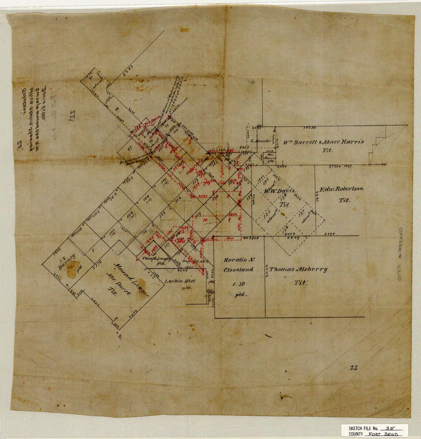
Fort Bend County Sketch File 25
Schutze's office sketch showing surveys around the KW Davis title
-
Map/Doc
11510
-
Collection
General Map Collection
-
Counties
Fort Bend Brazoria
-
Subjects
Surveying Sketch File
-
Height x Width
17.3 x 16.5 inches
43.9 x 41.9 cm
-
Medium
paper, manuscript
-
Features
Deer Creek
Part of: General Map Collection
Hockley County Working Sketch 1

Print $40.00
- Digital $50.00
Hockley County Working Sketch 1
1946
Size 26.0 x 60.9 inches
Map/Doc 66191
Harris County Sketch File 1

Print $20.00
- Digital $50.00
Harris County Sketch File 1
Size 14.8 x 12.6 inches
Map/Doc 25332
La Salle County Working Sketch 29

Print $20.00
- Digital $50.00
La Salle County Working Sketch 29
1955
Size 25.8 x 27.4 inches
Map/Doc 70330
Brewster County Rolled Sketch 130

Print $20.00
- Digital $50.00
Brewster County Rolled Sketch 130
1978
Size 18.4 x 24.6 inches
Map/Doc 5302
Harris County Working Sketch 119

Print $20.00
- Digital $50.00
Harris County Working Sketch 119
1984
Size 30.8 x 42.2 inches
Map/Doc 66011
Reeves County Working Sketch 24

Print $40.00
- Digital $50.00
Reeves County Working Sketch 24
1966
Size 38.7 x 76.5 inches
Map/Doc 63467
Nueces County Rolled Sketch 5

Print $20.00
- Digital $50.00
Nueces County Rolled Sketch 5
1910
Size 38.1 x 36.8 inches
Map/Doc 9584

Map of Red River County

Print $20.00
- Digital $50.00
Map of Red River County
1856
Size 22.2 x 18.4 inches
Map/Doc 3981
Brazoria County Sketch File 9

Print $6.00
- Digital $50.00
Brazoria County Sketch File 9
Size 14.0 x 9.0 inches
Map/Doc 14936
Hudspeth County Working Sketch 31

Print $40.00
- Digital $50.00
Hudspeth County Working Sketch 31
1972
Size 56.2 x 41.2 inches
Map/Doc 66314
Clay County Working Sketch 3

Print $20.00
- Digital $50.00
Clay County Working Sketch 3
1923
Size 19.7 x 9.3 inches
Map/Doc 68026
You may also like
Marion County Sketch File 12

Print $20.00
- Digital $50.00
Marion County Sketch File 12
1912
Size 25.1 x 14.2 inches
Map/Doc 12022
Schleicher County Working Sketch Graphic Index

Print $40.00
- Digital $50.00
Schleicher County Working Sketch Graphic Index
1940
Size 37.8 x 54.2 inches
Map/Doc 76694
Montague County Working Sketch 31

Print $20.00
- Digital $50.00
Montague County Working Sketch 31
1975
Size 25.5 x 25.8 inches
Map/Doc 71097
General Highway Map. Detail of Cities and Towns in Falls County, Texas

Print $20.00
General Highway Map. Detail of Cities and Towns in Falls County, Texas
1961
Size 18.1 x 24.4 inches
Map/Doc 79463
Webb County Sketch File 2

Print $20.00
- Digital $50.00
Webb County Sketch File 2
Size 20.0 x 18.2 inches
Map/Doc 12612

Jefferson County Sketch File 8a

Print $42.00
- Digital $50.00
Jefferson County Sketch File 8a
Size 8.6 x 7.8 inches
Map/Doc 28120
Flight Mission No. CUG-2P, Frame 7, Kleberg County

Print $20.00
- Digital $50.00
Flight Mission No. CUG-2P, Frame 7, Kleberg County
1956
Size 18.5 x 22.3 inches
Map/Doc 86179
Webb County Working Sketch 60

Print $20.00
- Digital $50.00
Webb County Working Sketch 60
1960
Size 43.3 x 47.8 inches
Map/Doc 72426
Hardin County Rolled Sketch 22

Print $20.00
- Digital $50.00
Hardin County Rolled Sketch 22
1977
Size 32.0 x 44.4 inches
Map/Doc 9110
Sherman County Rolled Sketch 4

Print $20.00
- Digital $50.00
Sherman County Rolled Sketch 4
Size 23.1 x 31.7 inches
Map/Doc 7786
Galveston County NRC Article 33.136 Sketch 65

Print $28.00
- Digital $50.00
Galveston County NRC Article 33.136 Sketch 65
2012
Size 24.0 x 36.0 inches
Map/Doc 93328