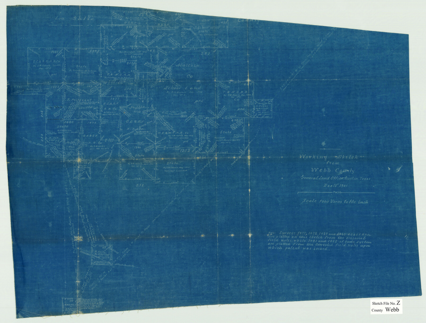
Webb County Sketch File Z
[Working sketch of surveys on the La Salle County line northeast from Laredo]
-
Map/Doc
12610
-
Collection
General Map Collection
-
Object Dates
12/12/1901 (Creation Date)
-
People and Organizations
J.W. Morris (Draftsman)
-
Counties
Webb
-
Subjects
Surveying Sketch File
-
Height x Width
16.8 x 22.2 inches
42.7 x 56.4 cm
-
Medium
blueprint/diazo
-
Features
Patilo Blanco Creek
Arroyo de los Olmos
Part of: General Map Collection
Gaines County Rolled Sketch 15C

Print $20.00
- Digital $50.00
Gaines County Rolled Sketch 15C
Size 33.6 x 22.7 inches
Map/Doc 75929
Gray County Working Sketch 7

Print $20.00
- Digital $50.00
Gray County Working Sketch 7
1971
Size 41.3 x 28.7 inches
Map/Doc 63238
Flight Mission No. CRC-3R, Frame 196, Chambers County

Print $20.00
- Digital $50.00
Flight Mission No. CRC-3R, Frame 196, Chambers County
1956
Size 18.7 x 22.3 inches
Map/Doc 84851
Crockett County Sketch File 44

Print $8.00
- Digital $50.00
Crockett County Sketch File 44
1881
Size 12.8 x 8.8 inches
Map/Doc 19768
Hemphill County Working Sketch 21

Print $40.00
- Digital $50.00
Hemphill County Working Sketch 21
1973
Size 79.0 x 32.6 inches
Map/Doc 66116
[Sketch for Mineral Application 13271- Trinity River]
![65628, [Sketch for Mineral Application 13271- Trinity River], General Map Collection](https://historictexasmaps.com/wmedia_w700/maps/65628.tif.jpg)
Print $40.00
- Digital $50.00
[Sketch for Mineral Application 13271- Trinity River]
1925
Size 63.1 x 22.4 inches
Map/Doc 65628
Flight Mission No. DQN-6K, Frame 6, Calhoun County

Print $20.00
- Digital $50.00
Flight Mission No. DQN-6K, Frame 6, Calhoun County
1953
Size 18.5 x 22.2 inches
Map/Doc 84428
Navarro County Sketch File 3

Print $8.00
- Digital $50.00
Navarro County Sketch File 3
1847
Size 10.2 x 8.1 inches
Map/Doc 32300
Bee County Working Sketch 28

Print $20.00
- Digital $50.00
Bee County Working Sketch 28
1988
Size 48.2 x 34.6 inches
Map/Doc 67278
Llano County Sketch File 8

Print $10.00
- Digital $50.00
Llano County Sketch File 8
1885
Size 14.1 x 8.8 inches
Map/Doc 30364
Flight Mission No. CLL-1N, Frame 77, Willacy County

Print $20.00
- Digital $50.00
Flight Mission No. CLL-1N, Frame 77, Willacy County
1954
Size 18.4 x 22.1 inches
Map/Doc 87023
Anderson County Sketch File 18

Print $40.00
- Digital $50.00
Anderson County Sketch File 18
1880
Size 16.0 x 13.5 inches
Map/Doc 10801
You may also like

Brewster County Rolled Sketch 22C

Print $20.00
- Digital $50.00
Brewster County Rolled Sketch 22C
1910
Size 23.7 x 18.8 inches
Map/Doc 5204
![94185, Texas [Recto], General Map Collection](https://historictexasmaps.com/wmedia_w700/maps/94185.tif.jpg)

[Town lots on Galveston Island]
![11, [Town lots on Galveston Island], General Map Collection](https://historictexasmaps.com/wmedia_w700/maps/11.tif.jpg)
Print $20.00
- Digital $50.00
[Town lots on Galveston Island]
1839
Size 18.8 x 23.0 inches
Map/Doc 11
Reeves County Working Sketch 61

Print $20.00
- Digital $50.00
Reeves County Working Sketch 61
1982
Size 32.1 x 31.4 inches
Map/Doc 63504
Robertson V Ranch

Print $20.00
- Digital $50.00
Robertson V Ranch
Size 41.7 x 46.0 inches
Map/Doc 89756
Northeast Part of Crockett County

Print $20.00
- Digital $50.00
Northeast Part of Crockett County
1976
Size 35.6 x 46.1 inches
Map/Doc 73120
Calhoun County Working Sketch 11

Print $20.00
- Digital $50.00
Calhoun County Working Sketch 11
1952
Size 43.1 x 34.9 inches
Map/Doc 67827
Terrell County Working Sketch 81

Print $20.00
- Digital $50.00
Terrell County Working Sketch 81
1988
Size 28.4 x 36.0 inches
Map/Doc 69602
Victoria County Rolled Sketch 2

Print $40.00
- Digital $50.00
Victoria County Rolled Sketch 2
1940
Size 61.1 x 18.5 inches
Map/Doc 10093
Map of Texas with population and location of principal towns and cities according to latest reliable statistics

Print $20.00
- Digital $50.00
Map of Texas with population and location of principal towns and cities according to latest reliable statistics
1921
Size 18.1 x 21.5 inches
Map/Doc 95880