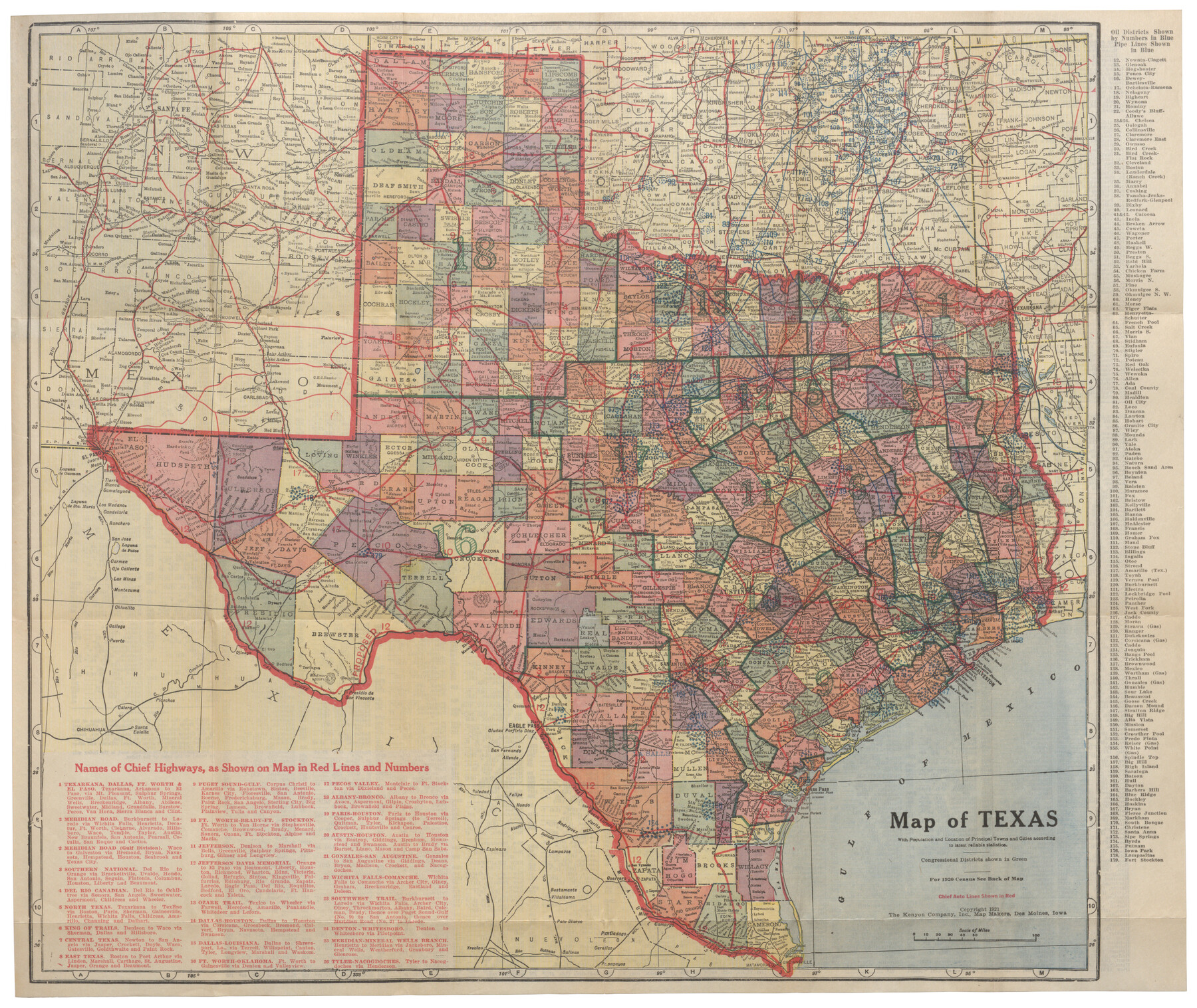
Map of Texas with population and location of principal towns and cities according to latest reliable statistics
-
Map/Doc
95880
-
Collection
Cobb Digital Map Collection
-
Object Dates
1921 (Creation Date)
-
People and Organizations
The Kenyon Company (Publisher)
The Kenyon Company (Printer)
-
Subjects
Railroads State of Texas
-
Height x Width
18.1 x 21.5 inches
46.0 x 54.6 cm
-
Medium
digital image
-
Comments
Courtesy of John & Diana Cobb.
To view 1920 census on verso and original booklet in which this map was folded, click "Download PDF" link above.
Related maps
Map of Texas with population and location of principal towns and cities according to latest reliable statistics

Print $20.00
- Digital $50.00
Map of Texas with population and location of principal towns and cities according to latest reliable statistics
1921
Size 19.0 x 22.2 inches
Map/Doc 94066
Part of: Cobb Digital Map Collection


The Sunshine Special - Quickest of 'em all - Hosuton to St. Louis leaves Houston 12:45 p.m. San Antonio 9 a.m.

Print $20.00
- Digital $50.00
The Sunshine Special - Quickest of 'em all - Hosuton to St. Louis leaves Houston 12:45 p.m. San Antonio 9 a.m.
1925
Size 9.0 x 7.7 inches
Map/Doc 95780
The United States

Print $20.00
- Digital $50.00
The United States
1907
Size 21.1 x 28.3 inches
Map/Doc 95859
Competing Transportation Lines between Boston, New York, Philadelphia, Baltimore, and the South Atlantic and Gulf States

Print $20.00
- Digital $50.00
Competing Transportation Lines between Boston, New York, Philadelphia, Baltimore, and the South Atlantic and Gulf States
1881
Size 15.1 x 17.8 inches
Map/Doc 95907
Typical Scenes of Wichita Falls and District

Print $20.00
- Digital $50.00
Typical Scenes of Wichita Falls and District
1927
Size 13.7 x 16.6 inches
Map/Doc 96761
Colonists' and Emigrants' Route to Texas

Print $20.00
- Digital $50.00
Colonists' and Emigrants' Route to Texas
1878
Size 14.8 x 23.7 inches
Map/Doc 95777
[Map 1:] A Geographically Correct County Map of States Traversed by the St. Louis, Iron Mountain and Southern Railway and its connections / [Map 2:] Map of the St. Louis, Iron Mountain and Southern Railway, and connections
![95784, [Map 1:] A Geographically Correct County Map of States Traversed by the St. Louis, Iron Mountain and Southern Railway and its connections / [Map 2:] Map of the St. Louis, Iron Mountain and Southern Railway, and connections, Cobb Digital Map Collection - 1](https://historictexasmaps.com/wmedia_w700/maps/95784.tif.jpg)
Print $20.00
- Digital $50.00
[Map 1:] A Geographically Correct County Map of States Traversed by the St. Louis, Iron Mountain and Southern Railway and its connections / [Map 2:] Map of the St. Louis, Iron Mountain and Southern Railway, and connections
1878
Size 18.9 x 32.2 inches
Map/Doc 95784

Map of the Southern Pacific Company and connections

Print $20.00
- Digital $50.00
Map of the Southern Pacific Company and connections
1890
Size 9.6 x 23.8 inches
Map/Doc 95759
You may also like
Baylor County Boundary File 5

Print $56.00
- Digital $50.00
Baylor County Boundary File 5
Size 8.1 x 62.3 inches
Map/Doc 50392
[Sketch for Mineral Application 13440]
![65673, [Sketch for Mineral Application 13440], General Map Collection](https://historictexasmaps.com/wmedia_w700/maps/65673.tif.jpg)
Print $40.00
- Digital $50.00
[Sketch for Mineral Application 13440]
Size 42.4 x 66.0 inches
Map/Doc 65673
Dickens County Sketch File 19a

Print $23.00
- Digital $50.00
Dickens County Sketch File 19a
Size 9.6 x 7.8 inches
Map/Doc 21031
Liberty County Sketch File 36a

Print $4.00
- Digital $50.00
Liberty County Sketch File 36a
Size 8.6 x 5.6 inches
Map/Doc 29974
Martin County Boundary File 2a

Print $6.00
- Digital $50.00
Martin County Boundary File 2a
Size 14.1 x 8.8 inches
Map/Doc 56776
Donley County Sketch File 22

Print $20.00
- Digital $50.00
Donley County Sketch File 22
Size 20.4 x 28.0 inches
Map/Doc 11368

Bee County Working Sketch 34

Print $20.00
- Digital $50.00
Bee County Working Sketch 34
1988
Size 46.3 x 43.6 inches
Map/Doc 67285
Butt's Map of Cooke County, Texas

Print $20.00
Butt's Map of Cooke County, Texas
1888
Size 17.5 x 14.5 inches
Map/Doc 88920
[Sketch around O. A. Seward surveys]
![91991, [Sketch around O. A. Seward surveys], Twichell Survey Records](https://historictexasmaps.com/wmedia_w700/maps/91991-1.tif.jpg)
Print $20.00
- Digital $50.00
[Sketch around O. A. Seward surveys]
Size 23.4 x 23.9 inches
Map/Doc 91991
Coast Chart No. 210 Aransas Pass and Corpus Christi Bay with the coast to latitude 27° 12' Texas

Print $20.00
- Digital $50.00
Coast Chart No. 210 Aransas Pass and Corpus Christi Bay with the coast to latitude 27° 12' Texas
1913
Size 27.6 x 18.2 inches
Map/Doc 72807
Presidio County Rolled Sketch 143

Print $20.00
- Digital $50.00
Presidio County Rolled Sketch 143
Size 40.2 x 36.8 inches
Map/Doc 90046