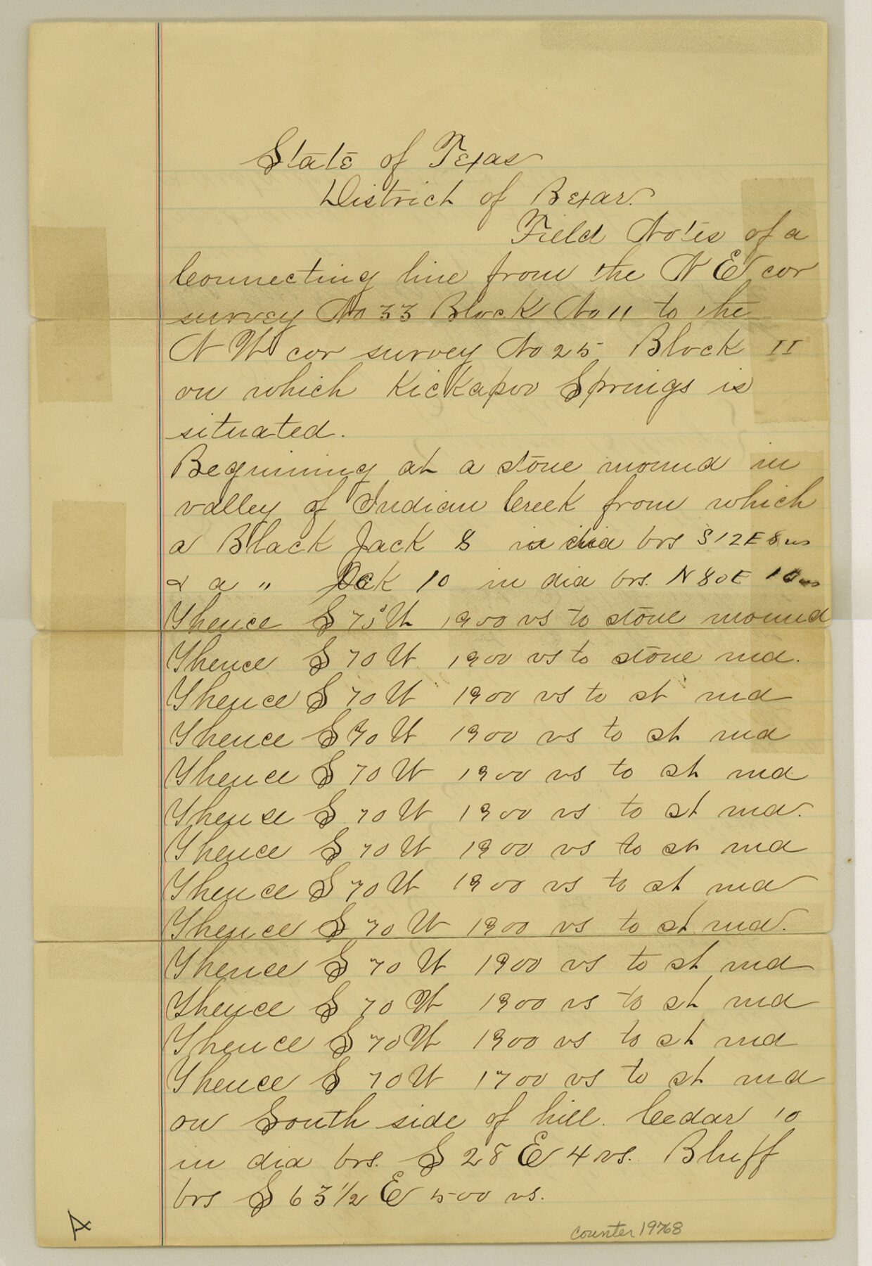
Crockett County Sketch File 44
[Connecting line from the northeast corner of survey 33, Block 11 to the northwest corner of survey no. 25, Block 11 where Kickapoo Springs is situated]
-
Map/Doc
19768
-
Collection
General Map Collection
-
Object Dates
1881 (Creation Date)
-
People and Organizations
Will H. Bonnell (Surveyor/Engineer)
Ammon Billings (Chainman)
B. Nolan (Chainman)
-
Counties
Crockett
-
Subjects
Surveying Sketch File
-
Height x Width
12.8 x 8.8 inches
32.5 x 22.4 cm
-
Medium
paper, manuscript
-
Features
Kickapoo Springs
Indian Creek
Nueces [River]
Part of: General Map Collection
Presidio County Rolled Sketch 102

Print $20.00
- Digital $50.00
Presidio County Rolled Sketch 102
1957
Size 19.3 x 13.8 inches
Map/Doc 7385
Reagan County Sketch File 9

Print $20.00
- Digital $50.00
Reagan County Sketch File 9
1928
Size 27.0 x 22.3 inches
Map/Doc 12216
Houston County Working Sketch 8

Print $20.00
- Digital $50.00
Houston County Working Sketch 8
1936
Size 41.6 x 30.5 inches
Map/Doc 66238
Crockett County Rolled Sketch 30

Print $20.00
- Digital $50.00
Crockett County Rolled Sketch 30
1934
Size 24.5 x 43.1 inches
Map/Doc 8700
Jefferson County Sketch File 48

Print $20.00
- Digital $50.00
Jefferson County Sketch File 48
1875
Size 19.8 x 21.0 inches
Map/Doc 11882
Liberty County Working Sketch 8

Print $20.00
- Digital $50.00
Liberty County Working Sketch 8
1906
Size 42.4 x 33.1 inches
Map/Doc 70467
Crane County Sketch File 18

Print $20.00
- Digital $50.00
Crane County Sketch File 18
1927
Size 15.1 x 18.4 inches
Map/Doc 11210
Red River County Working Sketch 43

Print $40.00
- Digital $50.00
Red River County Working Sketch 43
1968
Size 72.5 x 36.8 inches
Map/Doc 72026
Webb County Working Sketch 30

Print $20.00
- Digital $50.00
Webb County Working Sketch 30
1934
Size 15.0 x 40.6 inches
Map/Doc 72395
Pecos County Working Sketch 35

Print $20.00
- Digital $50.00
Pecos County Working Sketch 35
1939
Size 32.5 x 26.7 inches
Map/Doc 71507
North Part of Brewster Co.

Print $20.00
- Digital $50.00
North Part of Brewster Co.
1956
Size 42.4 x 40.2 inches
Map/Doc 1786
[Surveys along Bray's Bayou]
![157, [Surveys along Bray's Bayou], General Map Collection](https://historictexasmaps.com/wmedia_w700/maps/157.tif.jpg)
Print $2.00
- Digital $50.00
[Surveys along Bray's Bayou]
Size 7.6 x 4.9 inches
Map/Doc 157
You may also like
[Andrews County Road Map]
![92453, [Andrews County Road Map], Twichell Survey Records](https://historictexasmaps.com/wmedia_w700/maps/92453-1.tif.jpg)
Print $20.00
- Digital $50.00
[Andrews County Road Map]
1951
Size 18.6 x 25.6 inches
Map/Doc 92453
Flight Mission No. BQR-22K, Frame 34, Brazoria County

Print $20.00
- Digital $50.00
Flight Mission No. BQR-22K, Frame 34, Brazoria County
1953
Size 18.7 x 22.5 inches
Map/Doc 84118

Intracoastal Waterway - Laguna Madre - Rincon de San Jose to Chubby Island, Texas

Print $20.00
- Digital $50.00
Intracoastal Waterway - Laguna Madre - Rincon de San Jose to Chubby Island, Texas
1975
Size 16.0 x 37.1 inches
Map/Doc 73516
Hemphill County Working Sketch 16

Print $20.00
- Digital $50.00
Hemphill County Working Sketch 16
1971
Size 27.0 x 40.0 inches
Map/Doc 66111
Nueces County Rolled Sketch 51A

Print $20.00
- Digital $50.00
Nueces County Rolled Sketch 51A
1978
Size 27.6 x 39.1 inches
Map/Doc 6890
Aransas Pass to Baffin Bay

Print $20.00
- Digital $50.00
Aransas Pass to Baffin Bay
1966
Size 42.3 x 35.0 inches
Map/Doc 73415
Duval County Rolled Sketch Pressly No. 1A

Print $20.00
- Digital $50.00
Duval County Rolled Sketch Pressly No. 1A
1935
Size 25.4 x 37.6 inches
Map/Doc 5769
Current Miscellaneous File 54

Print $24.00
- Digital $50.00
Current Miscellaneous File 54
1955
Size 11.2 x 8.7 inches
Map/Doc 74042
Williamson County Sketch File 20

Print $4.00
- Digital $50.00
Williamson County Sketch File 20
Size 8.2 x 12.9 inches
Map/Doc 40348

Henderson County Sketch File 25

Print $2.00
- Digital $50.00
Henderson County Sketch File 25
1854
Size 8.1 x 3.8 inches
Map/Doc 26391