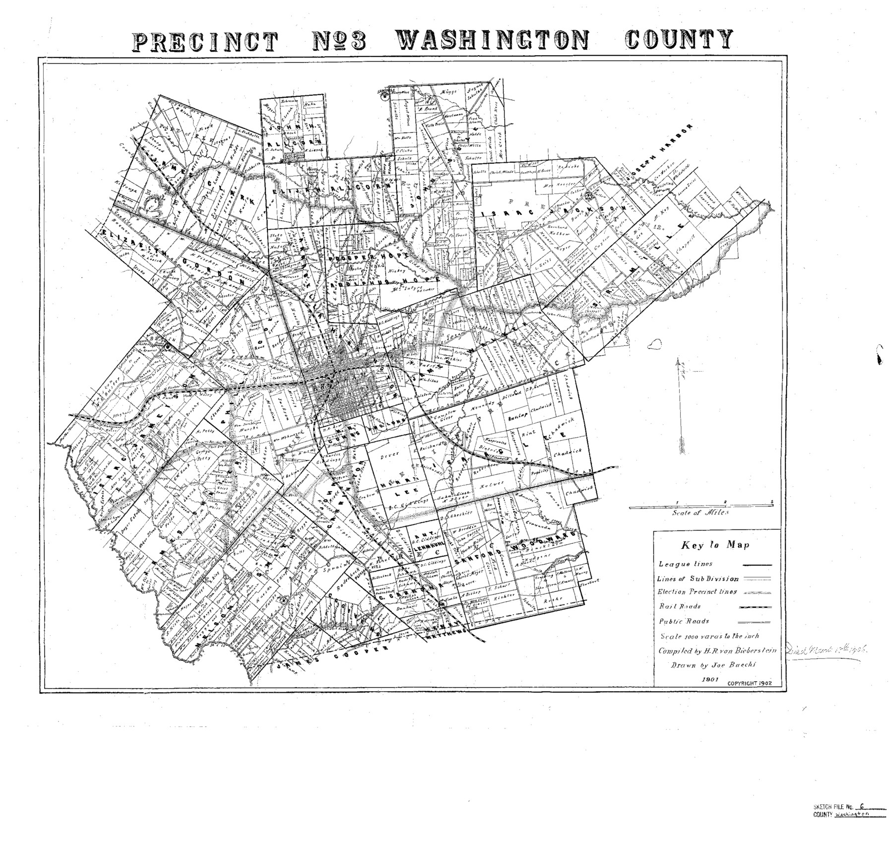
Washington County Sketch File 6
Precinct No. 3 Washington County
-
Map/Doc
12602
-
Collection
General Map Collection
-
Object Dates
1901 (Creation Date)
1902 (Copyright Date)
-
People and Organizations
Joe Buechi (Draftsman)
H.R. Von Bieberstein (Compiler)
-
Counties
Washington
-
Subjects
Surveying Sketch File County
-
Height x Width
24.7 x 26.0 inches
62.7 x 66.0 cm
-
Medium
paper, print
-
Scale
1" = 1000 varas
-
Features
Samuels
Tomlinson's Creek
County Farm
Kuykendall Creek
Brenham-Chappel Hill Road
Davidson Creek
Sandy Creek
Brenham Road
North Fork of Canal Creek
Ferry Creek
East Mill Creek
Smith Branch [of Mill Creek]
Williams Creek
Phillpsburg
Part of: General Map Collection
Flight Mission No. BRA-16M, Frame 168, Jefferson County

Print $20.00
- Digital $50.00
Flight Mission No. BRA-16M, Frame 168, Jefferson County
1953
Size 18.7 x 22.5 inches
Map/Doc 85766
Flight Mission No. DQN-1K, Frame 50, Calhoun County

Print $20.00
- Digital $50.00
Flight Mission No. DQN-1K, Frame 50, Calhoun County
1953
Size 18.7 x 22.3 inches
Map/Doc 84150
Webb County Rolled Sketch 20

Print $20.00
- Digital $50.00
Webb County Rolled Sketch 20
1928
Size 38.1 x 29.0 inches
Map/Doc 8182
Ector County Rolled Sketch HLG

Print $20.00
- Digital $50.00
Ector County Rolled Sketch HLG
1937
Size 45.2 x 30.2 inches
Map/Doc 8835
Gonzales County Working Sketch 5

Print $20.00
- Digital $50.00
Gonzales County Working Sketch 5
1980
Size 31.2 x 43.6 inches
Map/Doc 63221
Reeves County Rolled Sketch 35

Print $20.00
- Digital $50.00
Reeves County Rolled Sketch 35
2013
Size 25.3 x 36.8 inches
Map/Doc 93706
[Surveys on the Rio Frio]
![267, [Surveys on the Rio Frio], General Map Collection](https://historictexasmaps.com/wmedia_w700/maps/267.tif.jpg)
Print $2.00
- Digital $50.00
[Surveys on the Rio Frio]
1847
Size 11.8 x 7.3 inches
Map/Doc 267
Trinity County Sketch File 40

Print $20.00
- Digital $50.00
Trinity County Sketch File 40
1926
Size 16.5 x 21.8 inches
Map/Doc 12494
Castro County Working Sketch 3

Print $20.00
- Digital $50.00
Castro County Working Sketch 3
Size 31.7 x 17.9 inches
Map/Doc 67898
Harris County Working Sketch 27

Print $20.00
- Digital $50.00
Harris County Working Sketch 27
1933
Size 36.9 x 43.0 inches
Map/Doc 65919
Controlled Mosaic by Jack Amman Photogrammetric Engineers, Inc - Sheet 20

Print $20.00
- Digital $50.00
Controlled Mosaic by Jack Amman Photogrammetric Engineers, Inc - Sheet 20
1954
Size 20.0 x 24.0 inches
Map/Doc 83467
San Patricio County Working Sketch 7

Print $20.00
- Digital $50.00
San Patricio County Working Sketch 7
1936
Size 18.3 x 15.9 inches
Map/Doc 63769
You may also like
[Surveys in the Bexar District along the Frio and Leona Rivers]
![136, [Surveys in the Bexar District along the Frio and Leona Rivers], General Map Collection](https://historictexasmaps.com/wmedia_w700/maps/136.tif.jpg)
Print $20.00
- Digital $50.00
[Surveys in the Bexar District along the Frio and Leona Rivers]
1842
Size 16.2 x 12.2 inches
Map/Doc 136
Map of Terry County

Print $20.00
- Digital $50.00
Map of Terry County
Size 34.0 x 34.2 inches
Map/Doc 92933
Hardin County Sketch File 57

Print $40.00
- Digital $50.00
Hardin County Sketch File 57
Size 15.4 x 14.1 inches
Map/Doc 25228
Polk County Sketch File 25

Print $46.00
- Digital $50.00
Polk County Sketch File 25
Size 5.7 x 28.2 inches
Map/Doc 34176
From Citizens of Fannin County for the Creation of a New County to be Called Sherman, December 1, 1845

Print $20.00
From Citizens of Fannin County for the Creation of a New County to be Called Sherman, December 1, 1845
2020
Size 16.7 x 21.7 inches
Map/Doc 96397
Part of a Map Showing Resurvey of Capitol Leagues

Print $20.00
- Digital $50.00
Part of a Map Showing Resurvey of Capitol Leagues
Size 21.7 x 17.0 inches
Map/Doc 91557
Nueces County Sketch File 37

Print $2.00
- Digital $50.00
Nueces County Sketch File 37
1913
Size 11.2 x 8.6 inches
Map/Doc 32614
Stonewall County Sketch File 24

Print $6.00
- Digital $50.00
Stonewall County Sketch File 24
1951
Size 24.8 x 35.2 inches
Map/Doc 12369
Nueces County Rolled Sketch 130

Print $20.00
- Digital $50.00
Nueces County Rolled Sketch 130
2000
Size 17.2 x 23.8 inches
Map/Doc 7165
Kaufman County State Real Property Sketch 1

Print $92.00
- Digital $50.00
Kaufman County State Real Property Sketch 1
2006
Size 24.6 x 35.4 inches
Map/Doc 88624

Upton County Sketch File 22

Print $4.00
- Digital $50.00
Upton County Sketch File 22
1927
Size 11.2 x 8.5 inches
Map/Doc 38877