Webb County Rolled Sketch 20
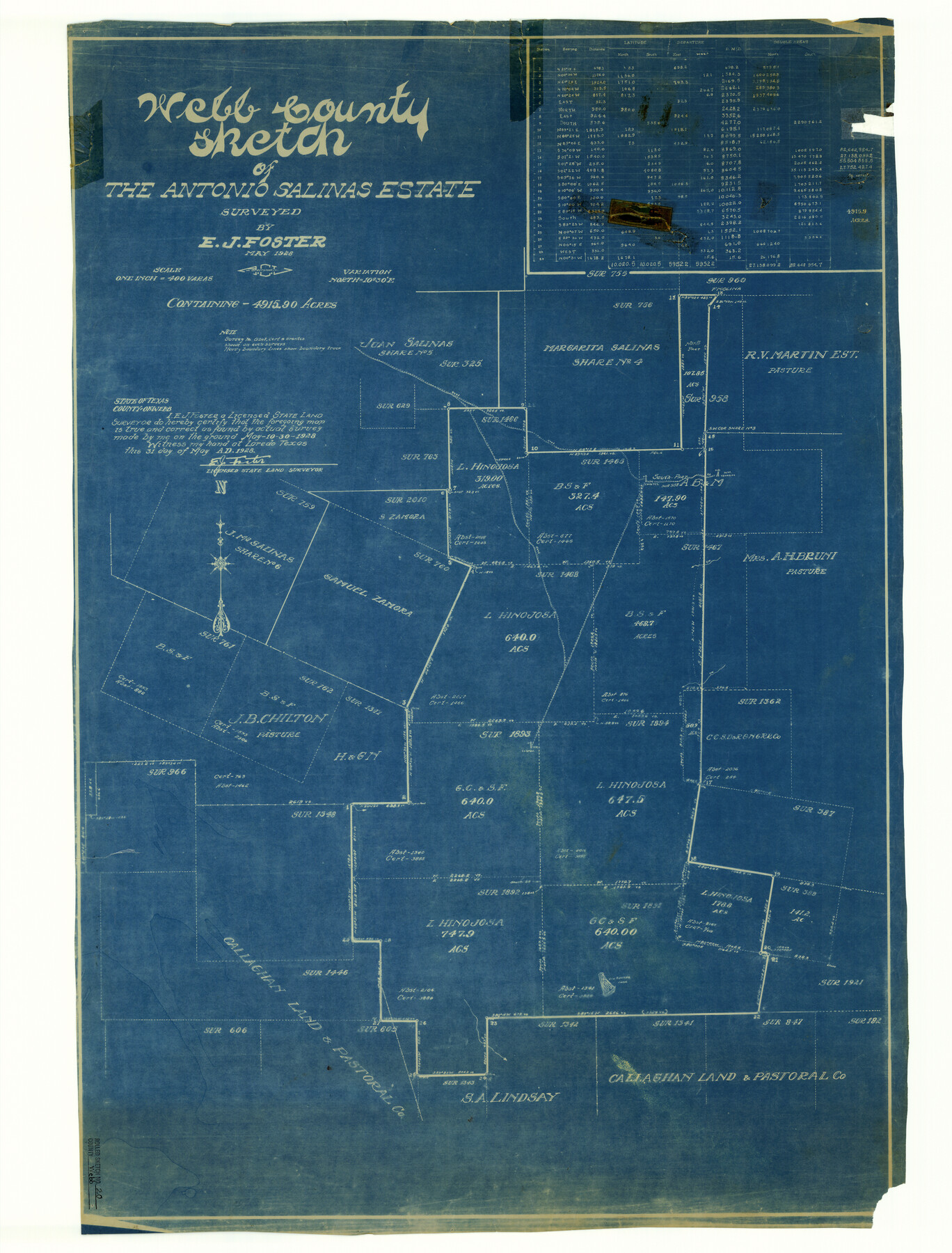
Webb County sketch of the Antonio Salinas estate
-
Map/Doc
8182
-
Collection
General Map Collection
-
Object Dates
1928/5/31 (Creation Date)
-
People and Organizations
E.J. Foster (Surveyor/Engineer)
-
Counties
Webb
-
Subjects
Surveying Rolled Sketch
-
Height x Width
38.1 x 29.0 inches
96.8 x 73.7 cm
-
Medium
blueprint/diazo
-
Scale
1" = 400 varas
Part of: General Map Collection
Map of the District of San Patricio and Nueces

Print $40.00
- Digital $50.00
Map of the District of San Patricio and Nueces
Size 93.8 x 67.5 inches
Map/Doc 1955
Gregg County Rolled Sketch JB1

Print $20.00
- Digital $50.00
Gregg County Rolled Sketch JB1
1933
Size 43.3 x 33.4 inches
Map/Doc 9024
Presidio County Sketch File 42

Print $4.00
- Digital $50.00
Presidio County Sketch File 42
1913
Size 10.2 x 8.2 inches
Map/Doc 34518
San Jacinto County Working Sketch 19

Print $20.00
- Digital $50.00
San Jacinto County Working Sketch 19
1939
Size 25.4 x 25.2 inches
Map/Doc 63732
Montgomery County

Print $20.00
- Digital $50.00
Montgomery County
1871
Size 21.0 x 24.6 inches
Map/Doc 3891

Presidio County Working Sketch 130

Print $20.00
- Digital $50.00
Presidio County Working Sketch 130
1989
Size 22.1 x 43.1 inches
Map/Doc 71808
Palo Pinto County Working Sketch 9

Print $20.00
- Digital $50.00
Palo Pinto County Working Sketch 9
1922
Map/Doc 71392
Dickens County Sketch File 15

Print $4.00
- Digital $50.00
Dickens County Sketch File 15
Size 12.6 x 8.0 inches
Map/Doc 20973

Cass County Working Sketch 30

Print $20.00
- Digital $50.00
Cass County Working Sketch 30
1980
Size 41.4 x 35.0 inches
Map/Doc 67933
Duval County Sketch File 35b

Print $6.00
- Digital $50.00
Duval County Sketch File 35b
1935
Size 14.4 x 8.8 inches
Map/Doc 21374
You may also like
Rand McNally Main Highway Map of Texas

Print $20.00
Rand McNally Main Highway Map of Texas
1923
Size 27.7 x 40.3 inches
Map/Doc 76260
Van Zandt County Sketch File 42

Print $4.00
- Digital $50.00
Van Zandt County Sketch File 42
1874
Size 10.0 x 8.1 inches
Map/Doc 39495
Pecos County Rolled Sketch DK5

Print $20.00
- Digital $50.00
Pecos County Rolled Sketch DK5
Size 24.3 x 16.8 inches
Map/Doc 7310
Jefferson County Rolled Sketch 17

Print $40.00
- Digital $50.00
Jefferson County Rolled Sketch 17
1931
Size 18.7 x 72.6 inches
Map/Doc 9281
Coryell County Sketch File 11

Print $4.00
- Digital $50.00
Coryell County Sketch File 11
Size 8.7 x 11.7 inches
Map/Doc 19364
Flight Mission No. BRA-16M, Frame 114, Jefferson County

Print $20.00
- Digital $50.00
Flight Mission No. BRA-16M, Frame 114, Jefferson County
1953
Size 18.5 x 22.3 inches
Map/Doc 85724
Galveston Co.

Print $40.00
- Digital $50.00
Galveston Co.
1891
Size 38.5 x 53.8 inches
Map/Doc 66834
Tyler County Sketch File 1a

Print $4.00
- Digital $50.00
Tyler County Sketch File 1a
1855
Size 8.2 x 10.3 inches
Map/Doc 38609
Ward County Boundary File 1

Print $12.00
- Digital $50.00
Ward County Boundary File 1
Size 14.4 x 9.0 inches
Map/Doc 59667
El Paso County Sketch File 20

Print $40.00
- Digital $50.00
El Paso County Sketch File 20
Size 31.4 x 49.4 inches
Map/Doc 10447
Zapata County Sketch File 7

Print $70.00
- Digital $50.00
Zapata County Sketch File 7
1918
Size 14.4 x 8.8 inches
Map/Doc 40911
Nautical Chart 885-SC Intracoastal Waterway - Ellender to Galveston Bay, Louisiana-Texas

Print $40.00
- Digital $50.00
Nautical Chart 885-SC Intracoastal Waterway - Ellender to Galveston Bay, Louisiana-Texas
1972
Size 16.1 x 59.4 inches
Map/Doc 69836