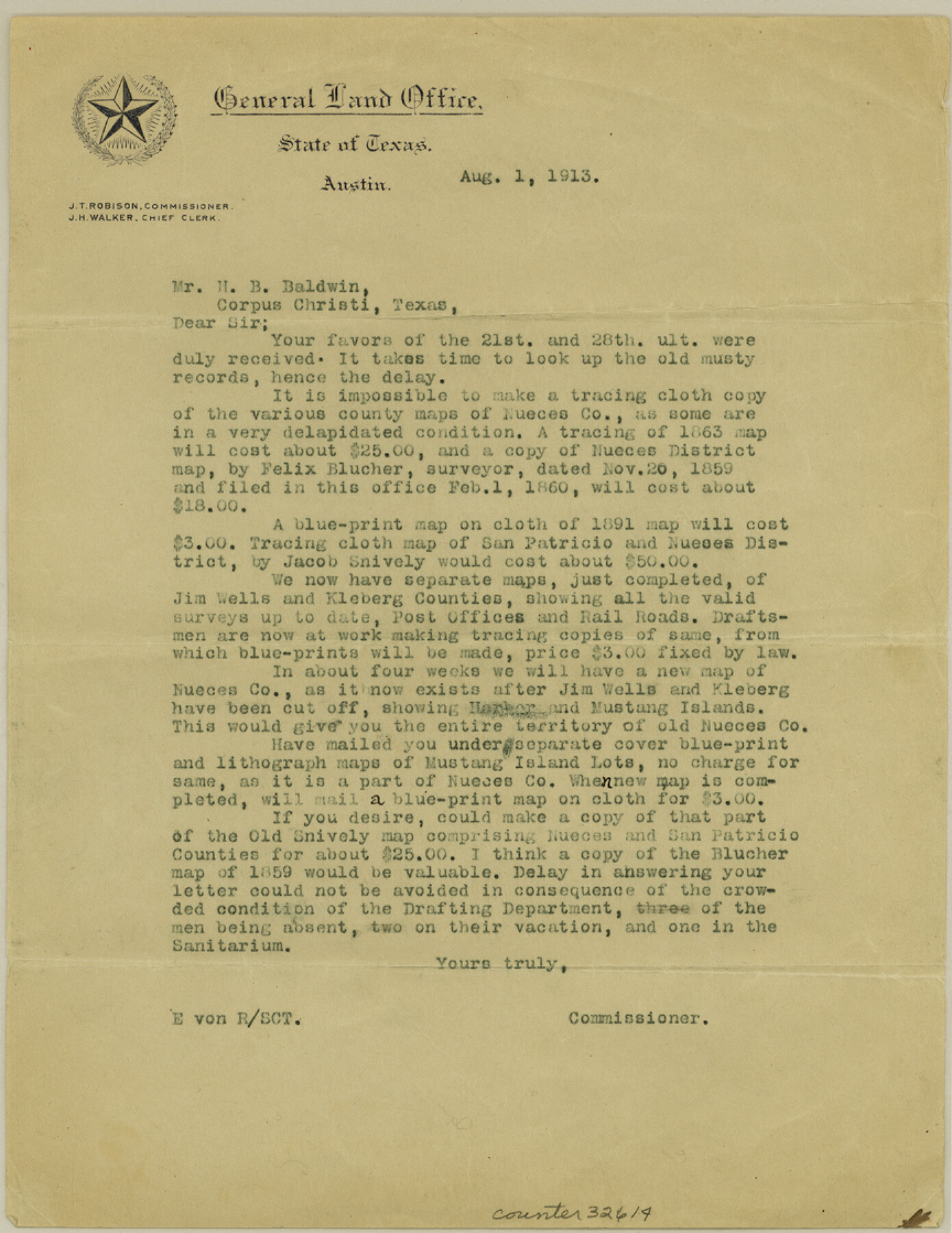
Nueces County Sketch File 37
[Letter to H. B. Baldwin to Commissioner of the GLO]
-
Map/Doc
32614
-
Collection
General Map Collection
-
Object Dates
8/1/1913 (Creation Date)
8/1/1913 (Correspondence Date)
11/20/1859 (Creation Date)
2/1/1860 (File Date)
-
People and Organizations
E. von Rosenberg (Surveyor/Engineer)
Felix Blucher (Surveyor/Engineer)
J.T. Robison (GLO Commissioner)
-
Counties
Nueces
-
Subjects
Surveying Sketch File
-
Height x Width
11.2 x 8.6 inches
28.4 x 21.8 cm
-
Medium
paper, print
-
Features
Harbor Island
Mustang Island
Part of: General Map Collection
Harris County Aerial Photograph Index Sheet 8

Print $20.00
- Digital $50.00
Harris County Aerial Photograph Index Sheet 8
1953
Size 22.2 x 16.8 inches
Map/Doc 83702
Pecos County Sketch File 31 1/2a

Print $14.00
- Digital $50.00
Pecos County Sketch File 31 1/2a
1931
Size 11.2 x 8.6 inches
Map/Doc 33705
[Surveys in the Bexar District along the Frio River and Commanche [sic] Creek]
![228, [Surveys in the Bexar District along the Frio River and Commanche [sic] Creek], General Map Collection](https://historictexasmaps.com/wmedia_w700/maps/228.tif.jpg)
Print $20.00
- Digital $50.00
[Surveys in the Bexar District along the Frio River and Commanche [sic] Creek]
1846
Size 23.8 x 18.9 inches
Map/Doc 228
Pecos County Working Sketch 34

Print $20.00
- Digital $50.00
Pecos County Working Sketch 34
1939
Size 32.7 x 27.6 inches
Map/Doc 71506
Mitchell County Working Sketch Graphic Index

Print $20.00
- Digital $50.00
Mitchell County Working Sketch Graphic Index
1971
Size 41.0 x 34.4 inches
Map/Doc 76644
Ward County Working Sketch 1

Print $20.00
- Digital $50.00
Ward County Working Sketch 1
1937
Size 24.7 x 24.5 inches
Map/Doc 72307
Coast Chart No. 208 - Pass Cavallo, Lavaca and San Antonio Bays, Texas

Print $20.00
- Digital $50.00
Coast Chart No. 208 - Pass Cavallo, Lavaca and San Antonio Bays, Texas
1888
Size 43.9 x 35.7 inches
Map/Doc 73376
Hill County Sketch File 8a

Print $4.00
- Digital $50.00
Hill County Sketch File 8a
1858
Size 10.2 x 8.1 inches
Map/Doc 26474
Archer County Sketch File 28-2

Print $40.00
- Digital $50.00
Archer County Sketch File 28-2
Size 21.4 x 16.9 inches
Map/Doc 10835

Presidio County Working Sketch Graphic Index, Northeast Part

Print $20.00
- Digital $50.00
Presidio County Working Sketch Graphic Index, Northeast Part
1973
Size 40.3 x 32.2 inches
Map/Doc 76674
Flight Mission No. BQR-4K, Frame 70, Brazoria County

Print $20.00
- Digital $50.00
Flight Mission No. BQR-4K, Frame 70, Brazoria County
1952
Size 18.8 x 22.4 inches
Map/Doc 84003
You may also like
Kimble County Working Sketch 36

Print $40.00
- Digital $50.00
Kimble County Working Sketch 36
1946
Size 53.6 x 43.1 inches
Map/Doc 70104
Flight Mission No. DQN-3K, Frame 6, Calhoun County

Print $20.00
- Digital $50.00
Flight Mission No. DQN-3K, Frame 6, Calhoun County
1953
Size 18.4 x 22.2 inches
Map/Doc 84338

Montgomery County Working Sketch 70

Print $20.00
- Digital $50.00
Montgomery County Working Sketch 70
1973
Size 41.3 x 31.7 inches
Map/Doc 71177
Tarrant County Boundary File 3

Print $30.00
- Digital $50.00
Tarrant County Boundary File 3
Size 11.4 x 8.8 inches
Map/Doc 59136
Sketch F No. 3 - Preliminary Chart of Key-West Harbor and Approaches

Print $20.00
- Digital $50.00
Sketch F No. 3 - Preliminary Chart of Key-West Harbor and Approaches
1852
Size 17.7 x 21.1 inches
Map/Doc 97218

Ochiltree County School Land League Number 204

Print $20.00
- Digital $50.00
Ochiltree County School Land League Number 204
1926
Size 20.8 x 13.7 inches
Map/Doc 92473
Hood County Rolled Sketch 6A

Print $4.00
- Digital $50.00
Hood County Rolled Sketch 6A
1996
Size 19.9 x 26.5 inches
Map/Doc 6223
Map of Harris County

Print $40.00
- Digital $50.00
Map of Harris County
1897
Size 48.4 x 66.9 inches
Map/Doc 82068
Van Zandt County Sketch File 36

Print $4.00
- Digital $50.00
Van Zandt County Sketch File 36
1864
Size 8.0 x 10.4 inches
Map/Doc 39478
Brazoria County NRC Article 33.136 Location Key Sheet

Print $20.00
- Digital $50.00
Brazoria County NRC Article 33.136 Location Key Sheet
1963
Size 27.0 x 22.0 inches
Map/Doc 77009